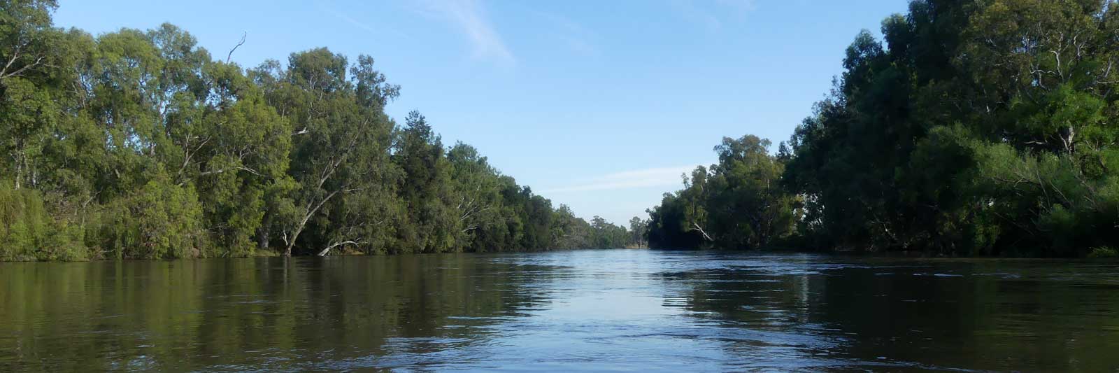
Murrumbidgee River
What to do while waiting for a vaccine or rain? With VIC reentering a lockdown and a dry winter up north, maybe the Murrumbidgee River could be a viable alternative. With a length of 1,615.8 km, it is the second longest river in Australia.
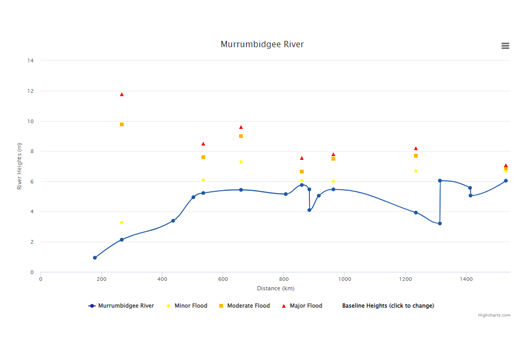
The Murrumbidgee River is usually considered to be the third longest river in Australia, GeoAustralia giving the length of 1,485 km calculated from the 1:250,000 National Topographic Database, or 1,482.3 km to be precise from BoM GeoFabric. However, manually tracing the distance from satellite images in QGIS, I calculated that the Murrumbidgee River at 1,615.8 km and the Darling River at 1,546.9 km, which was close to the GeoAustralia approximation of 1,545 km.
A mix of remote class 2 - 4 rapids and flat water sections would make for an exciting journey down to Jugiong.
- Source down to Tantangara Reservoir
- Short off-trail trek to the source, then high country streams down to the reservoir. ~65 km
- Tantangara Reservoir down to Binjura near Cooma
- Grade 2 - 3 rapids and at least one portage. ~115 km
- Binjura down to Cotter Dam, Canberra
- The river has mixed personalities along this stretch, from flat water sections to hard rapids with portages. ~130 km
- Cotter Dam down to Jugiong
- Another section with a long section of class 3 to 4 rapids. ~165 km
The main section of the river that is a tad over 1,000 km.
- Jugiong down to Wagga Wagga
- Fast running flat water, especially after the Tumut River just before Gundagai, slowing as you hit the Riverina proper. ~190 km.
- Wagga Wagga down to Narrandera
- ~200 km
- Narrandera down to Darlington Point
- ~100 km
- Darlington Point down to Hay
- ~145 km
- Hay down to Balranald
- ~300 km. The small town of Maude is about half way down this leg.
- Balranald to the Murray River
- ~105 km to the confluence. Continue down to Boundary Bend, Robinvale or even the ocean.
Once you have made it to the Murray River, it is another 117.0 km to Robinvale (VIC) / Euston (NSW), or you could organise a ride from Boundary Bend that is only 14.6 km downstream from the confluence. The rest area on Murray Valley Highway, VIC (B400) near Boundary Bend is only 9.2 km if you are struggling with tired arms!
Upper Sections
The section almost makes up for a third of the total length of the river (435.3 km) and has rapids up to grade 4 with a couple of compulsory portages.
Key Waypoints
-
0 km
Source
Easy trek on Peppercorn Fire Trail with a short 750 m off trail section to find the source.
-
64.7 km
Tantangara Reservoir (254GL)
Tantangara is a reservoir for Lake Eucumbene that is part of the Snowy Mountains Scheme network of dams. Water from Lake Eucumbene either makes its way naturally down to the south east coast via the Snowy River, or it is fed back into the Tumut and Murray hydro-electric power stations.
The remote gorge of this section passes through steep countryside that will be very dependent on the water levels. There are many small tributaries, two of the bigger ones are:
- Yaouk Creek
- Alum Creek
The gorge has consistent grade 2 to 3 sections with some approaching grade 4 with at least one compulsory portage. See Waterways Guide for details.
-
177.8 km
Binjura (Cooma)
Cooma is 5.2 km SES along Mittagang Rd.
Mixed farmland and gorges lead you down to the capital. The gorge has some class 2 to 4 sections and portages are likely.
See Waterways Guide for details, noting the guide for this section of the river is broken up into multiple legs.
- Numeralla River
- Bredbo River
The small town of Bredbo (pop. 350) is ~1.5 km away.
- Gudgenby River
-
307 km
Canberra (Cotter Dam)
Cotter Dam is about due west of the city centre but the early Point Hut Crossing is likely the closest that you will get to shops as you paddle by.
The satellite images suggest this next leg will be the most technical of the upper sections with a possible difficult portage around Burrinjuck Dam. Doing some research online using the Waterways Guide confirmed this.
Below Burrinjuck Dam is a 7 km section of class 3 to 4 rapids that ease as the river flattens out as you head towards Jugiong. It is best to do this section with a river height of 1.3-1.7 m.
Please refer to the Waterways Guide site for details about these sections.
- Point Hut Crossing
There is a large shopping centre 2.3 km walk from the bridge.
Point Hut Crossing is 22.7 km upstream from Cotter Road Bridge and ~100 km downstream from Binjura.
- Molonglo River
- Yass & Goodradigbee Rivers
Both rivers flow directly into Lake Burrinjuck.
- Burrinjuck Dam (1,028 GL)
This is a heritage-listed major gated concrete-walled gravity hydro-electric dam that is 93 m high.
-
472.7 km
Jugiong
Jugiong is a very small country town with a hotel and petrol station.
Lower Sections
The main section of the river. This starts off in the lower inland slopes of the Great Dividing Range but is mostly on the flat expansive alluvial plains of the Riverina that provides fertile agricultural land for many farms. As the river meets the Murray, you are at the boundary of the Riverina and the arid far western areas of NSW.
The average time it takes for water to flow down the Murrumbidgee from Jugiong to the River Murray confluence is approximately 25 days, or 45 km per day.
Key Waypoints
-
0 km(472.7 km)
Jugiong
There is a singular grade 1/2 rapid otherwise this section should be fast flowing flat water where the main concern is tree strainers on the outside banks, although a strong swirl in the outside of the right bend 2km from Gundagai was noted on Waterways Guide.
- Jugiong Creek
- Tumat River
This will likely significantly increase the flow of the river from here.
-
67.3 km(540 km)
Gundagai
According to the SMH, Gundagai is the iconic Australian country town.
The river flattens out now and the main concerns are snags in low flows or strainers when the river is in flood.
- Adelong Creek
- Billabong Creek
- Hillas Creek
- Tarcutta Creek
- Kyeamba Creek
-
189.6 km(662 km)
Wagga Wagga
Wagga Wagga is one of NSW largest inland cities.
- Houlaghans Creek
This creek appears to be usually dry from aerial photographs seen.
- Beavers Creek outflow
- Berembed Weir (3 GL) outflow
- Old Man Creek outflow
-
388.3 km(861 km)
Narrandera
Narrandera is a river town with a rich heritage. It stands on the land of the Wiradjuri nation and was once home to the Nharrangura Clan. There is a Coles and Mitre 10 in town.
- Yanco Creek outflow
Yanco Creek is one of the main distributaries that channels water off to the Murray River, albeit this is now controlled artificially by a system of weirs. The Yanco Weir is another 2.4 km downstream.
- Yanco Weir
-
Note that there is still 12.6 km of river before the Euroly Rd Bridge that leads to Yanco.
-
425.3 km(898 km)
Yanco
Yanco is a small country town with a small general store that is 6.2 km north of the river.
- Coleambally Main Canal outflow
- Sturt Canal outflow
The canal starts 1.6 km down a side arm of the river that branches off 340 m before the weir.
- Gogeldrie Weir (7 GL)
-
491.3 km(964 km)
Darlington Point
Small town with a variety of stores
-
617.9 km(1,091 km)
Carrathool
Carrathool is a small village 5.2 km north of the bridge along Carrathool Rd and I am uncertain if you can obtain supplies here so you need to be prepared for a 224 km leg between Darlington Point and Hay.
-
736.4 km(1,209 km)
Hay
Foodworks and IGA in town.
- Hay Weir (13 GL)
-
Flood: minor: 7.7 m, moderate: 8.7 m, major: 9.2 m
Flow: no flow: 1 m, recommended: above 1.78 m - Uara Creek outflow
Could this be a possible shortcut if water is very high? There seems to be only a marginal reduction in distance with high snag potential.
-
841.3 km(1,314 km)
Maude
- Maude Weir (5 GL)
- Lachlan River
Rarely flows outside of very high flow periods.
- North Redbank Channel outflow
This irrigation channel feeds the inland lakes of Pitarpunga and Tin Tin just to name two. In high floods, these will spill over and feed water back into the river via the usually dry Waldaira Creek.
The channel is 450 m above Redbank Weir.
- Redbank Weir (5 GL)
-
Flow: no flow: -0.48 m, recommended: above 0.1 m
- Uara Creek
Uara Creek rejoins after separating out 143.4 km upstream.
-
1,039.3 km(1,512 km)
Balranald
Sitting on the edge of the Riverina, Balranald is a fairly remote, semi-desert area bordering the arid far west areas of NSW. An IGA in town.
- Balranald Weir
-
Flood: minor: 6.7 m, moderate: 6.9 m, major: 7.1 m
Flow: no flow: 0.03 m, recommended: above 0.43 m
-
1,143.1 km(1,616 km)
Murray River
Refer to the Murray River guide if you intend to keep paddling down towards SA, though the first two towns that you could take out from are noted below.
- Boundary Bend (VIC)
You could organise a ride from the town or even maybe the rest area on Murray Valley Highway, VIC (B400) that is only 9.2 km downstream from the confluence if you are struggling with tired arms!
- Robinvale (VIC) / Euston (NSW)
This final section will likely add 2 or 3 days to your trip if you aim for these towns with the faster flowing waters of the Murray River.
There is an IGA in Robinvale which is the largest of the two towns.