Diamantina River

The Diamantina River System starts close to the NT / QLD border. It descends south towards Birdsville and Goyder Lagoon before flowing south west to Kati Thanda–Lake Eyre via two distributaries Warburton River and Kallakoopah Creek. This low gradient river passes through some of Australia's most remote arid and semi-arid environments including cutting through the centre of the Sturt Stony Desert at Birdsville. The combined length of the Diamantina and Warburton rivers is just over 1,400 km.
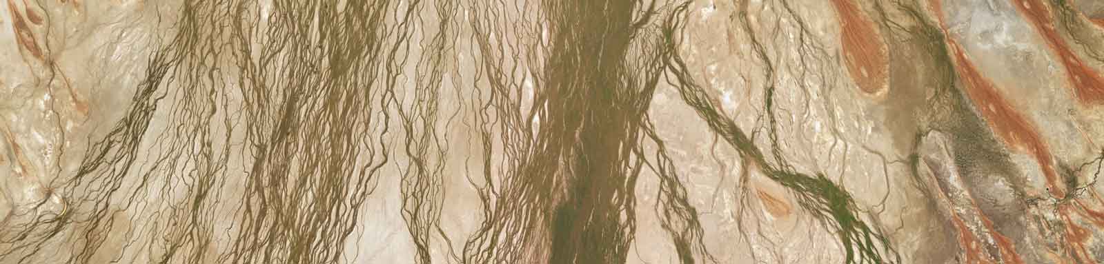
The Georgina–Diamantina catchment is commonly known as the channel country after the multi-channelled nature of the rivers that spread across the inland plains. The rivers are extremely variable and mostly ephemeral in nature, only flowing toward the terminal point at Kati Thanda–Lake Eyre after extremely high rainfall events in the NT / Northern QLD. The terminal point of Kati Thanda–Lake Eyre in SA is below sea level and has only completely filled a few times this century.
The system has an unregulated flow with low water extraction allowance. It will rarely flow outside of la Niña wet seasons and maybe cyclone driven weather events. Other than the extreme remoteness of the system, the main concern if attempting this river in anything other than in a large flood event would be that it doesn't reach the terminal and the flow spreads out over a vast number of channels that can be up to 50 km wide in places. Crocs shouldn't be a concern as it doesn't connect to any other Gulf river that might have crocodiles. The only known croc found was believed to have been dumped into the river around Birdsville back in 2013, a 1 meter freshwater crocodile.
Key Waypoints
-
0 km
Source
-
85 km
-
631 km
-
848 km
Birdsville
Centred in the Sturt Stony Desert, this is the only town of merit along the entire length of the river.

-
1,019 km
-
1,405 km
Kati Thanda / Lake Eyre
The mouth is on the northern side of the lake, 215 km flight from Marree, 260 km from Coober Pedy.
The Lake Eyre Yacht Club keeps a status update for the lake.
 crossing")

River Map
Key towns along the river are shown below.
- Kynuna
- Birdsville
- Diamantina Terminal
- Kati Thanda / Lake Eyre
Distance Table
The distances were calculated by manually digitising the river path from Bing aerial images in QGIS (WGS 84 / UTM Zone 55S).
| Distances (KM) | Source | Kynuna | Birdsville | Warburton River | Kati Thanda | Distances (KM) |
|---|---|---|---|---|---|---|
| Source | 0 | 85 | 848 | 1019 | 1405 | Source |
| Kynuna | 85 | 0 | 763 | 934 | 1320 | Kynuna |
| Birdsville | 848 | 763 | 0 | 171 | 558 | Birdsville |
| Warburton River | 1019 | 934 | 171 | 0 | 387 | Warburton River |
| Kati Thanda | 1405 | 1320 | 558 | 387 | 0 | Kati Thanda |
| Distances (KM) | Source | Kynuna | Birdsville | Warburton River | Kati Thanda | Distances (KM) |
Flow
There wasn't that much data on the river, but enough to do some basic analysis of the recent flow events. Some key observations:


Climate
A fairly isolated part of the system without much climate data. Gussing it'll be hot and dry with the northern edge subject to the northern moonsonal rains between November to April.
There are only two observation stations with data on the river, Winton in outback Queensland and Birdsville that sits on the Queensland South Australia border. Winton is far enough north to get some of the summer rains, but Birdsville has a hot desert climate with nearly hardly no rain. Birdsville currently holds the record for Queenslands hotest location with 49.5°C recorded on 24 December 1972.
And a more detailed head to head comparison of the two locations:
Winton
Mean Temps
Annual: 32.1°C
Monthly low: 8.2 to 23.5°C
Monthly high: 24.4 to 38.2°C
Mean Rainfall
Annual: 412 mm
Monthly min: 0 to 0 mm
Monthly max: 63 to 563 mm
Birdsville
Mean Temps
Annual: 30.5°C
Monthly low: 6.6 to 24.2°C
Monthly high: 20.8 to 38.8°C
Mean Rainfall
Annual: 163 mm
Monthly min: 0 to 0 mm
Monthly max: 57 to 300 mm
Seasonal Wind Roses for Winton (3pm)
These wind roses are based on limited data from early 2022 onwards.
Seasonal Wind Roses for Birdsville (3pm)
Seasonal Wind Roses for Marree (3pm)
Marree is about 100 km SE of Kati Thanda / Lake Eyre.
Access
Kynuna
It is serviced by a bus route (Greyhound) that runs between Mt Isa and Brisbane 7 days a week. If flying, Cloncury is likely the closest airport.
Road Crossings
There are a limited number of roads between Kynuna and Birdsville including:
Birdsville
Flying and driving are the only real options.
Road Crossings
Other than the Birdsville track that follows the creek down before the river turns west, there are no major outback roads that go near the river other than the station access tracks for Cowarie and Kalamurina homesteads.
Kati Thanda / Lake Eyre
At the time of writing access onto the water in the lake is restricted.
There are only two routes to the lakeshore. Both are public access routes as defined under the SA Pastoral Land Management and Conservation Act. These over private pastoral land that have unimproved and unsurfaced dirt tracks. You do not need to ask permission to the lessee to access these, but keep all gates as you found them and stay well clear of buildings / stock watering points. These two routes are:
- Halligan Bay lookout
- Passes through Anna Creek Station and terminates at a prominent point which cuts out into the lake to the north of Halligan Bay. Halligan Point is another 10km north. 4WD only
- Level Post Bay
- Located northwest of Muloorina Homestead, running along the northeast shore of Lake Eyre South, along the Goyder Channel and terminating at Level Post Bay in the Madigan Gulf of Lake Eyre North. 4WD only
Homesteads
Some of the stations and homesteads that can be found along the river.
There is a higher concentration of homesteads in the upper reaches, only Arizona and those right on the river are listed:
All homesteads located that were close to the water are listed from here
- 331 km Verdun Valley
- 379 km Brighton Downs
- 407 km Mayne Junction Hotel
- 455 km Diamantina Lakes
- 508 km Davenport Downs
- 629 km Monkira
- 746 km Durrie
- On the eastern branch
- 814 km Roseberth, QLD
- 4.6 km off Diamantina Dev Rd
- 883 km Pandie Pandie, SA
- 947 km New Alton Downs
- 1,046 km Clifton Hills
- 1,193 km Cowarie
- 6 km SE
- 1,200 km Kalamurina
