Ferns beside a still pool

Upper Murray River

14 Dec 2019 till 28 Dec 2019

Key Waypoints and Information

Wild rivers are earth's renegades, defying gravity, dancing to their own tunes, resisting the authority of humans, always chipping away, and eventually always winning.

Richard Bangs

From a planning perspective, the upper Murray River can be divided into four major sections, covering the walk-in and the upper 141 km of the river. These mountain reaches of the Murray are often referred to by it's Aboringal name, the Indi River.

Summit to Source
This leg covers the section from the summit of Mount Kosciuszko down to the source on the Black-Allan Line, covering a distance of approximately 60 km.
Source to Limestone Ck
The next leg involves trekking down the Murray River for approximately 15 km.
Limestone Ck to Tom Groggin
This leg requires pack rafting down to Tom Groggin, covering a distance of approximately 50 km.
Murray River Gorge
The final leg involves tackling the Grade I - IV rapids of the Murray River Gorge, covering a distance of approximately 70 km.
Each section presents its own challenges and rewards, and these are described in detail below:

There was a total of 180 km hiking Mt Kosciuszko down to the source with a gear drop to Limestone Creek. Due to low flows, I walked an additional 43 km down the Murray dragging the kayak with only about 82 km actual paddling. If I had travelled from the start to finish in good conditions and no gear drop, then I would have been looking at approximately 55 km on trails, 15 km off trails and 125 km kayaking!

Leg One: Summit to Source

14 Dec 2019

Man on stone cairn

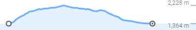
On foot from the summit of Mount Kosciuszko down to the source of the Murray River.

Key Waypoints

  • minus 45 km

    Jindabyne

    Elevation 926 m
    Coordinates 36° 24' 53.8" S, 148° 37' 7.6" E
    Population 2,630 Supermarket(s)

    Jindabyne is the last town on the bus timetables and the final major town before embarking on the alpine leg. It has a Woollies and a small general market in town to stock up on supplies.

  • minus 7.5 km

    Thredbo

    Date 14 Dec 2019
    Elevation 1,372 m
    Coordinates 36° 30' 11.6" S, 148° 18' 37.8" E
    Population 470 General Store
    Looking down a large hill to a town at the bottom

    The Foodworks in Thredbo is the last supply stop until the small general store in Jingellic, which is 285 km away. It is recommended that you stock up in Thredbo unless you are able to coordinate a supply drop along the way. At Bringenbrong Bridge you could try and hitch to the IGA in Corryong, Victoria, which is 13 km from the river.

  • 0 km

    Mount Kosciuszko

    Date 14 Dec 2019
    Elevation 2,228 m
    Coordinates 36° 27' 21.2" S, 148° 15' 48.9" E
    Metal grid path above grasses leading towards snow capped hills

    The official starting point for the summit to sea is unsurprisingly the summit of Mount Kosciuszko.

    While this is just an optional detour on any source to sea trip, it is highly recommened detour to the highest point in Australia that offers stunning views and amazing unique flora.

    If you choose to start from here, you can decide whether or not to take the chairlift to the top. Since the summit is considered to be the real starting point, the chairlift does not matter to the overall scheme of things. However, hiking to the top without taking the chairlift will make the journey feel more pure.

    With the car parked at Thredbo, this will be a loop to the summit starting from Thredbo and up to the summit (13 km), before heading down Dead Horse Gap trail (5 km), linking back to the car using the Thredbo River Track (4 km).

    Elevation profile graph
    26.2 km
    975 m
    6h 14min
    Option One: Merritts Nature Track
    4 km directly up from Thredbo on a steep track.
    or
    Option Two: Kosciuszko Express Chairlift
    Sit back and enjoy the view for 15 minutes as you climb 550 m to the Eagles Nest cafe.
    Kosciuszko Walk
    13 km Grade 3 track to the summit and back.
    Dead Horse Gap walking track
    Moderately steep track winds down to the valley.
    Thredbo River Track
    Follows the track down the river to Thredbo.

    Ultimately, I walked the entire loop from Thredbo with an overnight bivy at the top of Australia!

  • 55 km

    Cowombat Flat

    Date 21 Dec 2019
    Distance between locations 55 km Elevation 1,184 m
    Coordinates 36° 47' 46.5" S, 148° 11' 41.8" E
    Small stream in grasslands

    Cowombat Flat is located near the source of the Murray River. Cowombat comes from the local diaect meaning "woman", a fitting name for the birthplace of Australia's greatest river!

    Elevation profile graph
    42.6 km
    754 m
    1,124 m
    9h 17min
    Cascade (Hut) Trail

    This is an easy-to-navigate fire trail that leads past the Cascade Huts to the Tin Mine huts.

    Cowombat Flat Fire Trail

    The Cascade Trail ends at Tin Mine Huts, and the Cowombat Trail that heads southwest from here leads directly to Cowombat Flat, which is the source of the Murray River.

    Snow Gums & Pilot Creek Trails

    These trails are part of the Australian Alps Walking Track (AAWT), which is an alternative longer trek that leads down to Cowombat Flat.

    There is an old fire trail that leaves Snow Gums Trail and heads directly down the ridgeline towards Limestone Creek. This does not go all the way down and you will encountered thick bush on steep and unstable terrain if you attempt it. Long pants and gaiters are highly recommended when navigating off-trail.

    This should have been a fairly easy trek on various fire trails, but it was fairly dry and I had to watch my water very carefully. Water sites listed in the AAWT guide were low and dry in some cases.

  • 60 km

    Source (Black-Allen Line)

    Date 21 Dec 2019
    Elevation 1,349 m
    Coordinates 36° 47' 49.3" S, 148° 11' 48.3" E

    The Indi Springs are the de facto source for the Murray River, as it is the closest tributary to Cape Howe. A pipe was placed here by the RMIT survey group in 2006 during a survey of the start of the Black-Allan line.

    For more detailed info about finding the source can be found here.

    Map

    For me it was an easy hour's walk up the dry riverbed from Cowombat Flat in fairly open terrain to the Black-Allen line, but I hit dense bush as I explored further.

Leg Two: Source to Limestone Ck

22 Dec 2019

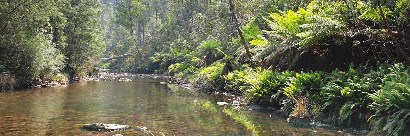
The stretch of the upper Murray River from the source down to Tom Groggin is the biggest unknown on my trip. Thoughts of impenetrable bush, dangerous floodwaters, or even snow could have made this a very intrepid journey.

What I found in early summer was an easily passable small mountain stream with some log jams, rocky outcrops and thick surrounding bush. There were a lot of animal trails due to the high number of feral horses that made detours away from the creek easy.

Key Waypoints

  • 60 km

    Source (Black-Allen Line)

    Date 21 Dec 2019
    Elevation 1,349 m
    Coordinates 36° 47' 49.3" S, 148° 11' 48.3" E

    The trip down from Cowombat Flat involves walking down the Murray River itself, with the exception of scrambling around a small number of waterfalls and deep pools.

    The walk is rated as Grade 5, the most difficult of the hiking grades, but it is at the easier end of the scale, with a number of easy scrambles and several deeper pools to navigate (depth of 1.3 m or greater).

    Ensuring your gear is safely waterproofed in dry bags or holding your pack above your head will allow you to avoid tricky scrambles around the rocky edge of some of the deeper pools.

    Rocky creek and trees
  • 78 km

    Limestone Ck

    Date 22 Dec 2019
    Distance between locations 20 km Elevation 854 m Slope 24.75‰
    Coordinates 36° 47' 29.4" S, 148° 6' 2.9" E

    The flow of the river significantly increases as Limestone Creek converges. This is likely the first place where you can start paddling.

    Two rivers joining

    I kept walking to my gear drop about 1.5 km further downstream and this was about 1 km upstream of the Poplars campground, a 4wd only access camping ground.

Leg Three: Limestone Ck to Tom Groggin

22 to 26 Dec 2019

3D Map

This is the longest section in the Pilot Wilderness Area, where my plan was to use a packraft to kayak down the Murray River with an optimistic goal of just two days.

With a good flow and whitewater experience, this section would only take one to two days to complete the 49 km distance. However, the worst-case estimate is as much as seven long days to traverse this 70 km section of the river.

It is important to note that without any flotation device (kayak / raft / lilo), trekking this section can be difficult in places due to fairly deep pools, steep rocky outcrops and frigid water temperatures.

River Data

A water level of at least 0.5m and flow of 500 ML/day are the likely good base levels as measured at the Biggara gauge. It is uncertain whether higher flood flows would wash out the rapids, but it would be more dangerous with the log jams.

Please note that the actual flow at the Poplars would be only about 10 to 20% of the flow seen at Biggara.

The conditions on my trip were challenging, with the river flow being low due to an extended dry spell. The entire journey took me a total of 4.5 long days on the river and another 3 days of walking to reach the source. The low flow made it difficult to paddle, forcing me to haul the kayak nearly 45 km through unpaddlable waters. On average, I was only able to make 1.5 km/hr wading the river and 1.2 km/hr when hauling the kayak through the shallows.

Originally, my trip was planned for mid-November, but it was unnecessarily delayed by two to three weeks waiting for the trail to be flagged as open, followed by an unseasonal late snowfall, and then work. Despite the delay, even in mid-November, the flow was still low, and I would have likely encountered similar difficulties.

While I had planned various escape routes before starting this trip, the smoke haze obscured most key bearings, and the thickness of the bush terrain made me extremely wary of trying to do any off-trail hiking unless it was absolutely necessary. This was especially true after already losing key survival gear during the gear drop. As such, once I was downstream of the Poplars, I considered that traversing up or down the Murray river as the only viable escape options.

Despite the challenges, I pushed on and successfully completed this leg of the journey without having to leave the river other than to skirt around the occasional log jam.

Key Waypoints

  • 78 km

    Limestone Ck

    Date 22 Dec 2019
    Elevation 854 m Slope 24.75‰
    Coordinates 36° 47' 29.4" S, 148° 6' 2.9" E
    Gauge: Biggara, MDBA
    Flow: recommended: above 0.5 m

    The influx of water from Limestone Creek will likely significantly increase the flow of the river.

    Rocky stream

    Passing by the Poplars marked the start of two solid days dragging the kayak along pools that were too shallow to paddle and even shallower rocky riffles.

  • 95 km

    Tin Mine Creek

    Date 24 Dec 2019
    Distance between locations 18 km Elevation 717 m Slope 7.61‰
    Coordinates 36° 39' 38.9" S, 148° 12' 9.2" E
    Ferns beside the river

    It was only with the influx of the various tributaries down to around Tin Mine Creek that allowed me to start paddling short sections (~80% dragging, ~20% paddling).

  • 110 km

    Cascade Creek

    Date 25 Dec 2019
    Distance between locations 15 km Elevation 629 m Slope 5.87‰
    Coordinates 36° 35' 33.4" S, 148° 12' 31.1" E

    This area is a pristine wilderness, untouched and isolated. It features deep pools with clear water and rocky outcrops, offering a stunning natural experience.

    Dingo on rock
  • 115 km

    Leather Barrel Ck

    Date 25 Dec 2019
    Distance between locations 5 km Elevation 604 m Slope 5.00‰
    Coordinates 36° 34' 43.1" S, 148° 10' 53.2" E

    This section of the river offers fun small runs and occasional Grade II rapids.

    Deep creek surrounded by rocks

    The additional flow finally allowed me to mostly paddle the remaining section down to Tom Groggin.

  • 127 km

    Tom Groggin Campground

    Date 26 Dec 2019
    Distance between locations 12 km Elevation 527 m Slope 6.42‰
    Coordinates 36° 32' 32.8" S, 148° 7' 43.4" E
    Two kangaroos

Leg Four: Murray River Gorge

27 & 28 Dec 2019

River with minimal water and a lot of boulders

Raft or walk?

Grade IV rapids would be a risky trip solo so I was contemplating either a guided raft trip or walking an extra 50 km along Harrington's Track.

A guided tour of the gorge would make the logistics should be fairly easy to finish this leg off. Otherwise, it will be traversing the gorge solo somehow, then hitchhiking the 80 km back to the car or vice versa.

River Data

A water level of at least 0.8m for the gorge is recommended for a true whitewater experience, which roughly corresponds to a height of 0.45m at Biggara.

Refer to the Biggara gauge for the current level and planning page for previous trip analysis of water flows.

Finishing leg two on Christmas day and knowing that the flow will be terrible, I didn't even try to contact Rafting Australia about the possibility of a guided trip. With a possibly suicidal mindset, I bit the bullet and decided to keep going. Surely it couldn't be that dangerous with these flows?

My rather stupid decision paid off and I had an amazingly fun trip through the gorge on what were probably mostly technical Grade II+ sections. Second day was mostly flat water paddling down to the Alpine Way where I caught three separate rides hitching to make it back to the car within 4 hours.

Key Waypoints

  • 127 km

    Tom Groggin campground

    Date 27 Dec 2019
    Elevation 527 m Slope 6.42‰
    Coordinates 36° 32' 32.8" S, 148° 7' 43.4" E
    Gauge: Biggara, MDBA
    Flow: recommended: above 0.5 m
    Old suspension bridge
  • 134 km

    Grassy Flat Rd

    Date 27 Dec 2019
    Distance between locations 7 km Elevation 526 m Slope 0.14‰
    Coordinates 36° 29' 11.1" S, 148° 7' 34.2" E

    Along this section of the river, there are a series of deep pools and occasional Grade II rapids, with a single Grade III drop known as "Riley's Ride", a tricky single drop with a large stopper at the bottom.

    This marks the last easy take-out point before the Murray River Gorge and the start of the Harrington's track on the Victorian side of the river, which offers an alternate route to bypass the Grade III+ to IV rapids.

    Calm river surrounded by cliffs
  • 138 km

    Murray Gates Rd (4wd)

    Date 27 Dec 2019
    Distance between locations 4 km Elevation 506 m Slope 5.00‰
    Coordinates 36° 27' 45.8" S, 148° 7' 26.1" E

    This marks the beginning of the more challenging whitewater section of Grade III+ to IV rapids.

    A more detailed guide on navigating the Murray Gates section can be found here.

    Man in front of some large rocks in the river

    I paddled this section with a reading of about 0.22 m at Biggara, about the absolute minimum level in a rubber ducky. This level was too low for a creek boat.

  • 153 km

    Biggara

    Date 28 Dec 2019
    Distance between locations 15 km Elevation 323 m Slope 12.20‰
    Coordinates 36° 20' 12.5" S, 148° 3' 10.9" E
    Gauge: Biggara, MDBA
    Flood: minor: 2 m, moderate: 2.6 m, major: 3 m
    Flow: no flow: -0.15 m, recommended: above 0.2 m

    This marks the end of the gorge and the beginning of scattered farmhouses along the river.

    Poplars and willow trees on the river banks.
  • 195 km

    Bringenbrong Bridge, Alpine Way (B400)

    Date 28 Dec 2019
    Distance between locations 38 km Elevation 265 m Slope 1.53‰
    Coordinates 36° 10' 9.1" S, 148° 1' 30.7" E

    This is a common starting point for those who choose to skip the upper sections.

    The additional flow generated from the waters of the Swampy Plains River changes the nature of the trip instantly, transforming it from a mountain creek to a true river. There are even reports of people putting in at Swampy Plains River at Khancoban.

    Despite the additional water entering the system, the flow was only 560 ML/day when I finished the upper section in 2019.

    Riverscape

    This marked the end of the first phase for me, as I was interrupted by commitments in Brisbane, QLD and closures due to the Corryong fire.