Cliffs at the border into SA

Lower Murray River

13 Dec 2020 till 20 Jan 2021

Key Waypoints and Information

Rivers know this: there is no hurry. We shall get there someday.

A. A. Milne

The lower section of the Murray River is more of an endurance test as it covers 2,356 km of the river's total length of 2,500 km.

The journey usually begins at Bringenbrong Bridge, which is downstream of the Swampy Plains River confluence. This point marks the transition of the Murray River from a small seasonal stream to a river. This section of the river is traditionally broken into two main sections, the wide fertile plains of the Riverina and the more arid sections of the Mallee. However, to make the guide more manageable, I have divided this lower section into major four legs:

The Free Flowing River
Fast running river down to Lake Hume and onto Albury. ~200 km
The Meeting of the waters
Albury to Echuca. Slower flat water paddling. ~480km.
The Merging of the Darling
Echuca to Wentworth. Wide open river. ~825km
Into the Malle
Slow waters from Wentworth to the ocean via Lake Alexandrina. ~800km

Common starting points downstream of Bringenbrong Bridge include:

Towong2,342 km
Sometimes used as it is the first town below Bringenbrong Bridge. It is just 14 km downstream from Bringenbrong Bridge.
Albury2,115 km
Albury is often used as it bypasses the smaller flowing section that can challenge some paddlers and provides more consistent and open flatwater paddling. Most start just upstream of Albury at the Hume Dam boatramp.
Echuca1,656 km
About a third of the way down the river and misses most of the faster flowing sections.

Coordinates will generally be at a takeout point or bridge for most locations. A couple of the smaller towns may not be obvious from the river, albeit only Nangiloc and Merbein are completely hidden from the river.

Leg One: The Free Flowing River

Lake surrounded by sun-baked hills

I have named this section after the fact that it is partially unregulated, despite the majority of the flow coming from the regulated release from Khancoban Pondage into Swampy Plain River. This section spans a distance of approximately 200 km from Bringenbrong Bridge to Lake Hume and then on to Albury. While the flat water makes for a relatively easy short start to the trip, this section is considered more challenging due to its winding nature with a fast flow and plenty of willow strainers that have claimed more than their fair share of paddlers over the years.

It is a great way to start your journey down the Murray River, providing a challenging warm-up to the longer sections to come.

River Data

I recommend that you have a water level of at least 1m at Bringenbrong Bridge, a level above 1.2m is even more preferable. It is also worth noting that the flow of the river can be affected by the release of water from Khancoban Pondage, so it is important to keep an eye on any water releases or alerts.

Key Waypoints

  • 195 km

    Bringenbrong Bridge, Alpine Way

    Date 13 Dec 2020
    Elevation 265 m Slope 1.52‰
    Coordinates 36° 10' 9.1" S, 148° 1' 30.7" E
    Gauge: Bringenbrong Bridge, MDBA
    Flood: minor: 3 m, moderate: 3.4 m
    Flow: no flow: 0.0 m, recommended: above 1 m

    The normal starting point for most paddlers where a fiberglass boat can be used with care down the riffles and easy rapids down to Lake Hume. This is the starting point where the The Inland Rivers National Marathon Register (IRNMR) starts their Murray River speed records from. No facilities other than a rest area with some picnic tables and a murray crayfish sculpture.

    The origin of the name is from the Aboriginal word meaning a bottomless waterhole.

    The bridge is 13 km by road from Corryong, the largest township in the area with a comprehensive array of stores and services including an IGA supermarket.

    Started with a low flow of 1,168 ML/day / 1.01 m, but I managed to paddle down without having to get out to drag the kayak. One grounding where I pushed through with my hands and a couple light scrapes / rudder taps.

    Riverscape

    Alternatively, you can start at Khancoban, upstream of Swampy Plains River. Swampy Plains River confluence is 2.4 km above the bridge, and the river is 12.2 km long as measured from the spillway at Khancoban.

    Khancoban was originally a service town for the Snowy Mountains Scheme, it now acts as a gateway to many of the local outdoor activities in the area. There is a roadhouse, chemist, caravan park, info centre and multiple other accominadation options. There is no scheduled public transport services to the town.

    The origin of the name is uncertain. Khan means royal in many languages but could also mean home or inn. Coban could be derived from the name of a person living in the area at the time (Cobban) with some speculating it was taken from the Turkish word for shepherd (çoban) implying it stands for top or royal shepherd.

  • 209 km

    Towong

    Date 13 Dec 2020
    Distance between locations 14 km Elevation 256 m Slope 0.64‰
    Coordinates 36° 7' 26.7" S, 147° 59' 46.5" E
    Population 280

    Small rural locality know for it's catlle and horses. There is a free campground on the NSW side but the town has no real facilities. Towong Cup is held every year in March at the historical Towong Turf Club.

    Town and shire were named after the Towong pastoral run (c. 1837) that is believed to be from the Aboriginal word meaning go away.

    The old last remaining timber beam bridge was replaced in 2022/23 with that section of the river closed to all water craft during removal and construction.

    Bridge

    The Snowy Scheme was increasing their water releases and the flow had increased overnight and this made navigation through the shallow sections much easier than the day before.

    As measured from the Bringenbrong gauge, we had a flow of 1,900 ML/day (1.17 m) on the 14th and that increased to 3,000 ML/day (1.38 m) on the 15th. We were close enough to get the increases overnight at Towong and some of the increase at the 45 km mark from Bringenbrong. The river height increased about ~15 cm overnight that really shows the importance of pulling your kayak up and/ or mooring it to something solid every night!

  • 240 km

    Tintaldra

    Date 14 Dec 2020
    Distance between locations 31 km Elevation 230 m Slope 0.84‰
    Coordinates 36° 2' 44.7" S, 147° 55' 56.1" E
    Population 200

    Small historic village with a pub (c. 1867) and cafe in the old general store (c. 1864). It was once an important crossing point for cross-state customs until Federation in 1901.

    The name is believed to be derived from an Aboriginal word describing a young man by the water by the local guides used by Charles Huon de Kerrilleau in 1837.

    Walwa (Aboriginal for a place of waters) is 1 km from the river, with the Walwa Riverside Caravan Park set on the banks of the river along with a general store in the township itself. It is 35 km downstream from Tintaldra, and 5 km upstream from Jingellic. Established for the old tin mine, the town now acts as a local hub for the dairy and tourism sectors.

  • 280 km

    Jingellic

    Date 15 Dec 2020
    Distance between locations 40 km Elevation 213 m Slope 0.23‰
    Coordinates 35° 55' 52.9" S, 147° 42' 4.8" E
    Population 60
    Gauge: Jingellic, MDBA

    A small quiet village home to the historic Bridge Hotel (c. 1925) and a serviced by a small general store. There is a free camping area in the reserve beside the boat ramp.

    Jingellic is an Aboriginal word, the meaning of which is no longer clear although there is a reference to the word meaning bald hill (maybe a reference to Pine Mountain) or simply slate country in referece to the local terain.

    Mirror waters on the river lined with trees

    Limited camping options on the upper Lake Hume section. Best to camp early or to have enough time up your sleeve to paddle well down into the lake.

  • 390 km

    Hume Dam

    Date 16 Dec 2020
    Distance between locations 109 km Elevation 195 m Slope 0.17‰
    Coordinates 36° 6' 27.7" S, 147° 1' 54.3" E

    The lake is approximately 50 km paddle if full, or a 85 km river paddle if empty.

    Portage for the dam is up the public boat ramp prior to the camping ground and the dam itself. It is a long portage, nearly 2 km up and over the hill at Lake Hume Village.

    Quick word of caution. Lake Hume is one of the most deadly areas on the entire system for paddlers. This is mainly due to the large number of beginner paddlers on the lake, but it can also get very rough in bad conditions that will test even experienced paddlers. You should keep an eye on the weather including the long term forecast as there is no mobile phone reception at the very top of the lake.

    The dam is named after Hamilton Hume, an early European explorer that discovered the Murray River near Albury in 1824. He actually named the river "The Hume" in honor of his father but this later changed to the River Murray by Captain Sturt in 1830.

    Lake Hume Village is a small NSW town with a caravan park and a couple other facilities. Bellbridge is a rural township on the Victorian side of the lake beside the historic Bethanga Bridge.

    Aerial photographs of Lake Hume

    At 85% capacity, the lake stretched most of the way up the valley. The difference in distance was probably minimal compared to that of a full lake.

    Some care was needed at the very top where the water was shallow over the flooded paddocks, and it paid to watch out for submerged logs that sometimes lurked just below the surface if taking shortcuts.

  • 416 km

    Albury, NSW / Wodonga, VIC

    Date 17 Dec 2020
    Distance between locations 27 km Elevation 154 m Slope 1.52‰
    Coordinates 36° 5' 5.5" S, 146° 54' 27.6" E
    Gauge: Doctors Point, MDBA
    Kayak on a calm lake

Leg Two: The Meeting of the Waters

Dead trees in a lake

This is a regulated section of the river that covers approximately 480 km from Albury to Echuca. Echuca is close to the junction of the Goulburn and Campaspe rivers with the Murray. This section features slower flat water paddling, which can still be moving fast enough to be challenging for some paddlers, especially near the dam if there are hazards such as fallen trees in the river.

River Data
Expecting the river to be easily navigable in any conditions, but higher flows will mean faster speeds. Refer to the Doctors Point gauge for the combined flow of both the Hume Dam water release and Kiewa River that joins up before Albury. August to March tends to have the highest flows.

Upstream of Echuca, the Barmah Choke restricts the flow to 10,000 ML/day or so. Any flows higher than this will spill out over the floodplains and more water will find it's way into the Edward River than the Murray itself.

I was expecting slower flat waters, but I still got a decent current assist down to Echuca of about up to 3-4 kph in places.

Key Waypoints

  • 416 km

    Albury, NSW / Wodonga, VIC

    Date 17 Dec 2020
    Distance between locations 27 km Elevation 154 m Slope 1.52‰
    Coordinates 36° 5' 5.5" S, 146° 54' 27.6" E
    Population 93,600 Supermarket(s)
    Drinking fountain beside the Mitta Mitta Canoe Club
    Gauge: Doctors Point, MDBA
    Flood: minor: 4.3 m, moderate: 4.9 m, major: 5.5 m

    Deep, fast, strong, clear and very cold waters await for you below the dam.

    Camping (BCF, Anaconda) and / or hardware supplies (Bunnings) are most easily obtained in North Albury, a short walk from the river, though the main supermarkets are a few blocks away from the main town waterfront at Hovell Tree Park.

    Sign on a tree with number 2224 written on it

    There was a consistent release of 15,000 ML/day (3 m) from the Hume Dam as measured from Doctors Point. The river was wide, clear and fairly cold.

    I found it very refreshing after the long portage in summer, it could be icy in winter! The river was fairly fast here still. With minimal effort I was up around the 10 kph mark. Overnight rain saw creeks flowing and the river took a slightly murky brown appearance that would stay till Lake Alexandrina.

  • 484 km

    Howlong, NSW

    Date 17 Dec 2020
    Distance between locations 68 km Elevation 149 m Slope 0.07‰
    Coordinates 35° 59' 9.9" S, 146° 37' 20.3" E
    Population 3,440
    Memorial Park beside the river where the Black Swan Anabranch joins the Murray
    Three birds in a tree
  • 526 km

    Corowa, NSW / Wahgunyah, VIC

    Date 18 Dec 2020
    Distance between locations 42 km Elevation 133 m Slope 0.38‰
    Coordinates 36° 0' 24.7" S, 146° 23' 42.9" E
    Population 5,480
    Boat ramp and toilets 2 km downstream. Tap beside a power pole.
    Gauge: Corowa, MDBA
    Flood: minor: 4.6 m, moderate: 5.9 m, major: 8.6 m
    Wide river

  • 608 km

    Yarrawonga, VIC / Mulwala, NSW

    Date 19 Dec 2020
    Distance between locations 82 km Elevation 124 m Slope 0.11‰
    Coordinates 36° 0' 31.2" S, 145° 59' 57.2" E
    Population 9,920
    Apex Park, JW Purtle and Owen Bridges Reserves, Mulwala. Maybe the toilets beside the bridge, Yarrawonga.
    Gauge: Yarrawonga Weir (downstream), MDBA
    Flood: minor: 6.4 m, moderate: 6.7 m, major: 7.8 m

    The weir at Yarrawonga / Mulwala creates Lake Mulwala that is very shallow. It is a graveyard for the river gums that were flooded when the weir was first constructed. It makes for a surreal experience.

    This is the second of the two portages on the Murray River, 700 m. From here you will have locks on all weirs. On the Yarrawonga side, follow the road around and across the train tracks / channel and keep going straight into the Yarrawonga Caravan Park. A public boat ramp can be found just past the main office.

    The lake is about the first time on the trip you have to start taking more care with power boats in the holiday periods.

    Kayaking a calm lake
  • 678 km

    Cobram, VIC / Barooga, NSW

    Date 21 Dec 2020
    Distance between locations 70 km Elevation 112 m Slope 0.06‰
    Coordinates 35° 54' 58.3" S, 145° 40' 9.5" E
    Population 7,830
    Tap beside picnic tables at beach downstream of the bridges

  • 707 km

    Tocumwal, NSW

    Date 21 Dec 2020
    Distance between locations 29 km Elevation 112 m Slope 0.00‰
    Coordinates 35° 48' 47.3" S, 145° 33' 31.5" E
    Population 2,680
    BBQ area near pontoon and Town Beach Caravan Park.
    Heavy rain on the river
  • 832 km

    Barmah, VIC

    Date 24 Dec 2020
    Distance between locations 125 km Elevation 103 m Slope 0.07‰
    Coordinates 36° 1' 8.9" S, 144° 57' 18.3" E
    Population 280
    Gauge: Barmah, MDBA

    Barmah is about 30 km after Picnic Point, NSW that has a couple of caravan parks.

    The Barmah Choke is upstream. This is actually three key flow constriction points between Tocumwal and Barmah: the Tocumwal, Barmah and Edward Chokes.

    Trees beside the river

    Flow was slowly reducing down, being closer to around 8,000 ML/day to 10,000 ML/day for most of the river between Yarrawonga and Wentworth.

    Having only recently paddled around Picnic Point a couple weeks back with 4,000 ML/day extra, the difference through the choke was significant. However, I made the same time around Robinvale with the reduced flow. The flow has less significance on the wider open river found downstream.

  • 881 km

    Echuca, VIC / Moama, NSW

    Date 24 Dec 2020
    Distance between locations 50 km Elevation 103 m Slope 0.00‰
    Coordinates 36° 7' 18.8" S, 144° 45' 12.8" E

    Home to both old and new paddle steamers and houseboats.

    Echuca is named after the Yorta Yorta word meaning "meeting of the waters", in reference to the Goulburn and Campaspe confluences.

    Paddle boats beside a wharf

Leg Three: The Merging of the Darling

Two large slow moving rivers joining together

This is a transitional section of the river and is named after the confluence of two of the most important rivers of the basin. That and the fact that this is also the final town entry / exit point before heading into South Australia. This section covers approximately 825 km from Echuca to Wentworth where the Murray transforms into a much older wider river and the landscape starts to transistions as the mallee pushes into the riverina. The system becomes fully regulated with a series of weirs that slowly drain disapate the flowing current. I lost the main current assist around Nangiloc (just upstream of Mildura)

Key Waypoints

  • 881 km

    Echuca / Moama

    Date 24 Dec 2020
    Distance between locations 50 km Elevation 103 m Slope 0.00‰
    Coordinates 36° 7' 18.8" S, 144° 45' 12.8" E
    Population 20,490 Supermarket(s)
    Tap on a tree in the Aquatic Reserve beside Info Centre. Fountain near the Thong Trees downstream.
    Flood: minor: 93.5 m, major: 94.4 m
    Gauge: Echuca, MDBA

    Fairly laidback historical town, but it can be very busy around the holiday period with hundreds of power boats on the water from Barmah all the way down to Torrumbarry Weir.

    Paddle boat on the river and houseboats moored to the shoreline

    It was the busier location on the river of the entire trip especially towards Torrumbarry Weir, but that was just before Victoria slammed its borders with NSW shut because of SARS-CoV-2 so it is probably not the best year to compare towns along the river. Apparently Mildura usually takes this title, yet it was dead quiet this year.

    Take care of the power boats, I found a couple here to be fairly irresponsible, particularly around the wakeboarding club upstream of Echuca and at Torrumbarry Weir.

  • 967 km

    Lock 26 - Torrumbarry Weir

    Date 26 Dec 2020
    Distance between locations 86 km Elevation 85 m Slope 0.21‰
    Coordinates 35° 56' 35.7" S, 144° 27' 56.2" E
    Population 280
    Gauge: Torrumbarry Weir (downstream), MDBA
    Flood: minor: 7.3 m, major: 7.8 m

    Very popular spot for power boaters upstream.

    First of the locks as you head down the river.

    Weir across the river
  • 1,075 km

    Barham, VIC / Koondrook, NSW

    Date 28 Dec 2020
    Distance between locations 107 km Elevation 85 m Slope 0.00‰
    Coordinates 35° 37' 50.1" S, 144° 7' 29.4" E
    Population 1,930
    One tap along Barham foreshore by the bridge is labelled potable, but the water was cloudy and hot. Non-potable?

    Little Murray River, NSW
    Coordinates 35° 26' 48.2" S, 143° 48' 55.2" E

    8.5 km downstream of Barham. Stay on the major branch by going left rather than cutting back hard to the right. These meet back up in 26.5 km.

    Little Murray River, VIC
    Coordinates 35° 26' 48.1" S, 143° 48' 54.9" E

    Second major split in the river, 26 km downstream from where the last branches converged, or 60 km downstream of Barham. Stay on the obvious major branch by going right. These meet up again just before Swan Hill that is about 55 km away.

    Small wallaby
  • 1,191 km

    Swan Hill, VIC

    Date 29 Dec 2020
    Distance between locations 116 km Elevation 75 m Slope 0.09‰
    Coordinates 35° 20' 15.7" S, 143° 33' 46.3" E
    Population 11,100 Supermarket(s)
    Tap on the outside of the BBQ shelter near the 10 Steps and another beside the bridge.
    Gauge: Swan Hill, MDBA
    Flood: minor: 4.5 m, major: 4.7 m

    Bridge
    Beveridge Island, VIC
    Date 29 Dec 2020
    Coordinates 35° 14' 14.9" S, 143° 33' 50.8" E
    General Store

    19 km downstream of Swan Hill, take the shorter left anabranch (5.5 km) rather than the longer main branch (11 km). This deviates off the NSW / VIC border. The Speewa ferry is about 1 km downstream from where these two branches converge.

    Nyah, VIC
    Date 30 Dec 2020
    Distance between locations 48 km Elevation 75 m
    Coordinates 35° 10' 22.1" S, 143° 23' 32.6" E Date Bridge, 1.4 km upstream of the town
    Population 480

    Small town 45 km downstream of Swan Hill with a few shops but you only really see a couple houses and the harness track paddling by.

    Wood Wood, VIC
    Date 30 Dec 2020
    Coordinates 35° 6' 14.4" S, 143° 20' 48.1" E
    General Store

    Another small town 60 km downstream of Swan Hill that you could easily miss with about a dozen houses and a caravan park / store.

  • 1,274 km

    Tooleybuc, NSW

    Date 30 Dec 2020
    Distance between locations 83 km Elevation 66 m Slope 0.11‰
    Coordinates 35° 1' 49.7" S, 143° 20' 6.9" E
    Population 280 General Store
    Drinking fountain beside playground

    Small town by the river with a store and pub. A new pontoon has been installed beside the playground and public toilet.

    Bridge and pontoon on a river
  • 1,364 km

    Boundary Bend

    Date 31 Dec 2020
    Distance between locations 90 km Elevation 56 m Slope 0.11‰
    Coordinates 34° 42' 51.8" S, 143° 8' 49.9" E
    Population 130

    More of a single stop gas station, roadhouse and caravan park. Easily accessible with the boat ramp.

    Mirror surface on wide river
  • 1,455 km

    Robinvale, VIC

    Date 1 Jan 2021
    Distance between locations 92 km Elevation 55 m Slope 0.01‰
    Coordinates 34° 34' 38.9" S, 142° 46' 1.3" E
    Population 3,310 Supermarket(s)
    Behind the boat ramp, the Arts Centre has a tap that seems potable
    Gauge: Euston Weir (downstream), MDBA
    Flood: minor: 9.1 m, major: 10.3 m

    Popular small town in the middle of nowhere that seems to attract a high number of power boats!

    Multiple tow boats line the shore and 5 guys water skiing behind a single boat
    Euston, NSW
    Coordinates 34° 10' 16.0" S, 142° 4' 54.4" E
    Population 800 General Store

    Small town just downstream. The Euston Weir - Lock 15 is 6.2 km downstream of Robinvale.

    Robinvale can get extremely busy with water skiers and wakeboarders during the summer school break and they also host a water ski race around easter.

  • 1,605 km

    Nangiloc

    Date 4 Jan 2021
    Distance between locations 150 km Elevation 48 m Slope 0.05‰
    Coordinates 34° 28' 19.8" S, 142° 21' 24.6" E
    Population 140 General Store

    Small town with a pub / general store, 500 m from the boat ramp. It is also the point where almost all of the current assist disappears. A gentle breeze will push you back upstream!

  • 1,682 km

    Mildura, VIC / Buronga, NSW

    Date 5 Jan 2021
    Distance between locations 77 km Elevation 42 m Slope 0.08‰
    Coordinates 34° 10' 59.2" S, 142° 10' 24.3" E Date Bridge is 1.5 km upstream of the Mildura Weir.
    Population 53,030 Supermarket(s)
    Drinking fountains on foreshore and splash park, Mildura
    Gauge: Lock 11 - Mildura Weir (downstream), MDBA
    Flood: minor: 36.0 m, major: 38.5 m

    The lock is in a separate channel to the left of the weir going downstream. It is also the only lock that runs to a schedule, down on the hour, up on the half hour.

    Two large boats and kayak in lock
    Merbein, VIC
    Coordinates 34° 10' 16.0" S, 142° 4' 54.4" E
    Population 1,980

    Small town slightly off the Murray. You do not see the town from the river.

    I was noticing the flow reduction from around Nangiloc and this was exacerbated by a heavy kayak stocked up with lots of fresh food and drinks for the next leg.

  • 1,736 km

    Wentworth

    Date 6 Jan 2021
    Distance between locations 54 km Elevation 37 m Slope 0.09‰
    Coordinates 34° 6' 44.7" S, 141° 54' 35.1" E
    Two large slow moving rivers joining together

Leg Four: Into the Malle

Emu chicks and one of their parents by the water

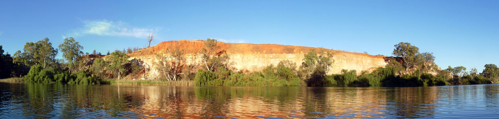
This has arguably some of the most scenic riverscapes of the entire system where the river snakes it's way through red clay cliffs and onto the towering golden limestone cliffs of South Australia. This is a mostly regulated section that covers a distance of approximately 800 km. After the meeting of the waters, you are faced with the most remote section throught the most arid regions of the entire system before the river becomes peppered with numerious small holiday towns before finishing in the Coorong where you are getted with extensive wetlands and sand-dunes before finally reaching of the the Southern Ocean, making it an excellent way to end the journey.

While you get willow trees along many stretches of the river from Biggara, it is below Swan Reach where these become increasingly common and completely choke the riverbanks making it difficult to come ashore. Finding camping spots are much harder.

The final stretch is the shallow waters of Lake Alexandrina. The shoreline is generally free of willows and a few beaches can be found in among the reeds that line the shore. This lake can get rough and has claimed the lives of many boaters in the past, including a kayaker just weeks before my crossing.

With nearly no flow assist, and being at the end, this section is often considered to be the toughest physically and mentally of the entire trip by many.

Key Waypoints

  • 1,736 km

    Wentworth

    Date 6 Jan 2021
    Elevation 37 m Slope 0.09‰
    Coordinates 34° 6' 44.7" S, 141° 54' 35.1" E Date Convergence of the Darling River.
    Population 1,250 Supermarket(s)
    Beside toilets, Junction Park
    Gauge: Wentworth Weir (Lock 10), MDBA
    Flood: minor: 32.1 m, major: 33.9 m

    You finally meet the waters of the Darling River here. The main services in town are 1.5 km up the Darling River.

    Lock 10 - Wentworth Weir is 600 m downstream.

    Lock on the river
  • 1,798 km

    Lock 9 - Kulnine Weir

    Date 7 Jan 2021
    Distance between locations 63 km Elevation 32 m Slope 0.08‰
    Coordinates 34° 11' 28.5" S, 141° 35' 52.4" E
    Gauge: Lock 9 (downstream), MDBA

    The river starts to get quiet below lock 9. Campers and fishermen are less common.

    Cliffs

    The river felt that it stopped flowing about lock 9 where water was diverted to Lake Victoria. Some water being released from the lake did assist slightly below lock 7, but that will disappear quickly and the tiny flow assist that was still remaining around Mildura will disappear completely for the rest of the trip to the ocean.

  • 1,838 km

    Lock 8 - Wangumma Weir

    Date 9 Jan 2021
    Distance between locations 40 km Elevation 29 m Slope 0.08‰
    Coordinates 34° 7' 43.3" S, 141° 23' 57.8" E
    Gauge: Lock 8 (upstream), MDBA

    The section between lock 8 to 7 is probably the most remote of all of the sections of the Murray, albeit I was never alone for more than a few hours at a time during the school summer holiday period.

    Trees and beach beside a river

  • 1,868 km

    Lock 7 - Rufus River Weir

    Date 10 Jan 2021
    Distance between locations 29 km Elevation 28 m Slope 0.03‰
    Coordinates 34° 4' 4.6" S, 141° 14' 44.1" E
    Gauge: Lock 7 (downstream), MDBA

    The Rufus River just below lock 7 would allow one to paddle up to Lake Victoria.

    Old wooden sign nailed to a tree
    NSW - SA border
    Coordinates 34° 1' 18.8" S, 141° 0' 10.7" E

    This is a three-way border (MacCabe Corner) in the centre of the Murray River, 48 km downstream of lock 7. Up till this point, the Murray River was completely within NSW with one or two minor exceptions, and for the next 11 km the VIC - SA border runs along the centre of the river.

    High cliff beside the river
    VIC - SA border
    Coordinates 33° 58' 50.3" S, 140° 57' 49.0" E

    The VIC border is 11 km downstream of the NSW border. This particular anomaly between the two borders is due to errors when first surveyed resulting in the VIC-SA border being 4 km west of where it should have been drawn.

    It was a fairly stunning farewell to VIC with the cliffs just past the VIC - SA border. This was a real taster of what was to come. The mixed colour clay cliffs reminded me of Bryce Canyon National Park in the USA but in a greatly reduced scale being limited to the water's edge

  • 1,947 km

    Lock 6 - Murtho Weir

    Date 11 Jan 2021
    Distance between locations 79 km Elevation 24 m Slope 0.05‰
    Gauge: Lock 6 (downstream), MDBA
  • 2,000 km

    Renmark

    Date 12 Jan 2021
    Distance between locations 53 km Elevation 20 m Slope 0.08‰
    Coordinates 34° 10' 18.3" S, 140° 45' 3.5" E
    Population 7,490
    Drinking fountain beside info centre, plus others
    Gauge: Lock 5 (downstream), MDBA

    The historical Paringa Lifting Bridge is 3.8 km further downstream at Paringa (pop 950) that is on the eastern side of the river.

    Town beside a river
    Lock 5 - Renmark Weir
    Coordinates 34° 11' 17.7" S, 140° 45' 58.8" E

    1.3 km downstream of the bridge.

  • 2,043 km

    Berri

    Date 12 Jan 2021
    Distance between locations 43 km Elevation 16 m Slope 0.09‰
    Coordinates 34° 17' 23.1" S, 140° 35' 59.7" E
    Population 4,100
    Colourful cliff by river
    Lock 4 - Bookpurnong Weir
    Coordinates 34° 20' 32.5" S, 140° 34' 35.7" E
    Gauge: Lock 4 (downstream), MDBA

    9 km downstream of Berri.

  • 2,081 km

    Loxton

    Date Bypassed
    Distance between locations 37 km Elevation 14 m Slope 0.05‰
    Coordinates 34° 26' 54.7" S, 140° 33' 52.9" E
    Population 4,570
    Tap at John Hamilton Memorial Lions Park

    Town is fairly spread out along the river banks upstream ~5km before the main town centre.

    Katarapko Creek (right)
    Coordinates 34° 20' 46.0" S, 140° 33' 5.8" E
    Distributary 25 km upstream Loxton

    Katarapko Creek has a small stone weir near the top. It is 16.8 km long and saves 15.3 km but bypasses Loxton and one of the best beaches on the river at Whirlpool Bend. It has numerous campsites and provides a quiet retreat from the main river in school holidays with more abundant wildlife than along the main river.

    Water running over a small rock dam
  • 2,120 km

    Moorook

    Date 13 Jan 2021
    Distance between locations 39 km Elevation 11 m Slope 0.08‰
    Coordinates 34° 17' 22.0" S, 140° 22' 8.7" E
    Population 290 General Store
    Tap by shed on foreshore by boat ramp
    Gauge: Lock 3 (downstream), MDBA

    Small town on the left (western side) as you head downstream. Cobdogla (pop 230) is on the right and Barmera (pop 1,900) is 5 km east.

    Barmera could be accessible via Lake Bonney. However the entrance to Lake Bonney appears to be a fair way downstream making for a 15 km paddle one way.

    Tent on a beach beside a river and tall cliff
    Lock 3 - Overland Corner Weir
    Coordinates 34° 11' 17.4" S, 140° 21' 29.4" E

    20 km downstream of Moorook

  • 2,190 km

    Waikerie

    Date 14 Jan 2021
    Distance between locations 71 km Elevation 10 m Slope 0.01‰
    Coordinates 34° 10' 32.2" S, 139° 59' 11.4" E Date Waikerie Ferry
    Population 2,680 Supermarket(s)
    Toilets, maybe in the water park just past these
    Gauge: Lock 2 (downstream), MDBA
    Stripped colours on a tree trunk
    Lock 2 - Waikerie (Taylorville) Weir
    Coordinates 34° 4' 37.2" S, 139° 55' 54.1" E

    21 km downstream of Waikerie

  • 2,254 km

    Morgan

    Date 15 Jan 2021
    Distance between locations 64 km Elevation 8 m Slope 0.03‰
    Coordinates 34° 2' 18.7" S, 139° 40' 21.5" E Date Ferry crossing
    Population 430 General Store
    Toilets uphill towards town
    Gauge: Morgan, MDBA
    Kayak on mirror glass water

  • 2,301 km

    Blanchetown

    Date 16 Jan 2021
    Distance between locations 46 km Elevation 6 m Slope 0.04‰
    Coordinates 34° 20' 43.1" S, 139° 36' 58.8" E Date Bridge
    Population 210 General Store
    RV Dump by park off the river slightly. Below the lock.
    Gauge: Lock 1 (downstream), MDBA
    Lock 1 - Blanchetown Weir
    Coordinates 34° 21' 0.4" S, 139° 36' 56.3" E

    Blanchetown is roughly half way through SA where the A20 crosses the Murray.

    Tall cliffs

    On the way to Mannum, you'll pass a large number of holiday homes and tiny towns including, but not limited to:

    Swan Reach (left)
    Coordinates 34° 33' 54.0" S, 139° 35' 51.3" E
    Population 280 General Store
    29 km from Blanchetown
    Punyelroo (right)
    Coordinates 34° 36' 9.3" S, 139° 36' 9.9" E
    Population 260
    34 km from Blanchetown
    Nildottie (left)
    Date 17 Jan 2021
    Coordinates 34° 40' 44.1" S, 139° 38' 52.4" E
    Population 190 General Store
    51 km from Blanchetown
    Walker Flat (right)
    Coordinates 34° 45' 14.8" S, 139° 34' 6.8" E
    Population 50 General Store
    68 km from Blanchetown
    Bowhill (left)
    Coordinates 34° 53' 3.5" S, 139° 37' 21.1" E
    Population 140 General Store
    90 km from Blanchetown, 34 km from Mannum
  • 2,427 km

    Mannum

    Date 18 Jan 2021
    Distance between locations 126 km Elevation 2 m Slope 0.03‰
    Coordinates 34° 54' 35.6" S, 139° 19' 3.3" E Date Mannum Ferry
    Population 2,640 Supermarket(s)
    From memory, a tap by the toilets

    Sea water would commonly penetrate up past Mannum in the drier dry seasons before the construction of the Murray Mouth Barrages in the 1930s.

    Paddle steamboat docked
  • 2,467 km

    Murray Bridge

    Date 18 Jan 2021
    Distance between locations 40 km Elevation 1 m Slope 0.02‰
    Coordinates 35° 6' 56.1" S, 139° 16' 47.6" E
    Population 17,560 Supermarket(s)
    Gauge: Murray Bridge, MDBA
    Bridge at sunset

  • 2,492 km

    Tailem Bend

    Date 19 Jan 2021
    Distance between locations 25 km Elevation 1 m Slope 0.00‰
    Coordinates 35° 15' 22.3" S, 139° 27' 11.3" E
    Population 1,670 General Store

    Toilets on the foreshore and other attractions / facilities at the top of the cliff.

    Willow trees lining the river banks
    Wellington (right)
    Coordinates 35° 19' 53.2" S, 139° 23' 5.4" E
    Population 295
    13 km from Tailem Bend
  • 2,519 km

    Lake Alexandrina (Head)

    Date 19 Jan 2021
    Distance between locations 27 km Elevation 1 m Slope 0.00‰
    Coordinates 35° 21' 54.3" S, 139° 21' 57.5" E

    Nearing the end. The lake is roughly 15 km across and 30 km long.

    This lake can get very rough due to it being shallow and fairly unsheltered, so ensure you tackle it with care and with an updated weather report. The left hand side shoreline is considered the safest.

    An in depth guide for Lake Alexandrina

    Sunrise over a lake

    Arriving at the lake at lunch, I choose to wait it out for better conditions rather than risking the crossing. It isn't worth the risk if it is windy!

  • 2,563 km

    Southern Ocean

    Date 20 Jan 2021
    Distance between locations 44 km Elevation 0 m Slope 0.02‰
    Coordinates 35° 33' 19.6" S, 138° 52' 48.0" E
    Gauge: Lower Lakes Barrages, MDBA

    The Lower Lakes barrages prevent the influx of sea water into Lake Alexandrina.

    Goolwa (pop.2,350), 35° 30' 12.6" S, 138° 47' 12.1" E, is 11 km west of the river mouth, accessible from either side of the islands.

    Person on a beach with the ocean in the background

    The Tauwitchere Barrage lock is self-operated for anyone travelling in a party of two or more, and there is a padded ramp for solo paddlers. Northerly winds will create a lot of chop from waves bouncing off the barrages.