Logan River
Pre-trip planning for a paddle on the Logan outside of the regular canoe trails, as such treat all information here above MacLean Bridge (67.8 km) with a gain of salt.
The lower reaches of the river are tidal and generally between 50 m and 100 m wide although some sections towards the mouth are over 500 m. This section is popular with boaters and there is a kayak / canoe trail on the river around lower tidal sections around Logan.
There are multiple put-in points along the river depending on your plans, time and flow / tides.
What to expect
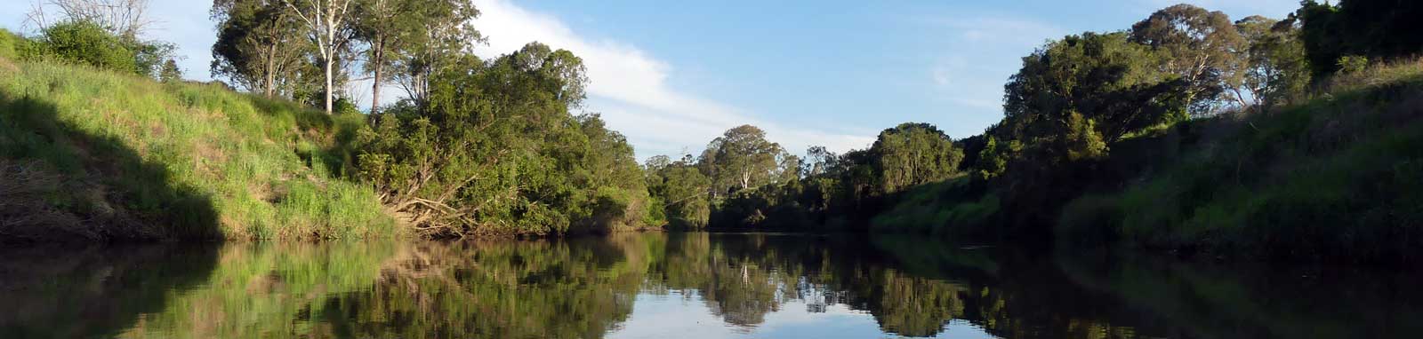
The lowest 10 km is wide and characteristic of the channels of the Gold Coast Broadwater but quickly become more like a large typical tidal river for the next 50 km though mostly built up areas.
Above this long flat sections appear to be linked with shallow sandy / gravel sections all the way up to around Beaudesert with frequent vegetation / log jams. This is a mix of farmland and large lifestyle blocks. The final sections to Beaudesert is mostly farmland.
Above this the river becomes stepper and rockier and potentially not naviagatable. The source is on the ridgeline between Mt Ernest and Mt Lindesay that marks the QLD and NSW border.
Being tidal, it pays to plan ahead to catch the right flow for the most enjoyable trip, especially when doing side trips up any tributaries such as Alburt River. The tidal nature of the river is also the cause of the thick sticky mud that you should try to avoid. Tidal flows peak at around 2 to 4 kph, but if needed you can hug the inside banks to avoid some of this current.
Logistics
There are multiple put points along the river operated mostly by Logan or Gold Coast city councils. The Gold Coast council runs the parks south of the Logan River and east of the Albery River. The Logan council runs the remaining parks from the mouth up until Teviot Brook on the western side and Allan Creek on the eastern side. From this point, the remaining upstream sections are in the Scenic Rim Regional Council that goes up to the NSW border.
Some parks are closed overnight, so check before you set off.
The following are likely the better spots to put in, but there are some other locations that you can use too. Refer to the Distance Table and the Interactive Map to find many of the other options that you can use. Parking is not an issue in general.
- 4 km
- Marks Road Boat Ramp
- 9.4 km
- Riedel Park Boat Ramp
Riedel Road, Carbrook - 11.5 km
- August Burow Park Boat Ramp
Alberton Road, Alberton (south)
Bayside Wake Boat Ramp
Ferry Road, Carbrook (north) - 17.3 km
- Skinners Park Boat Ramp
Skinners Park, Carbrook - 21.7 km
- Logan River Parklands Boat Ramp
Eagleby - 23.1 km
- Alexander Clark Park Poontons
Loganholme
- 28.3 km
- Tansey Park Boat Ramp
Tansey Drive, Tanah Merah - 32.4 km
- Federation Drive Boat Ramp
Bethania - 34.8 km
- Larry Story Park Boat Ramp
Albert St, Waterford - 44.7 km
- Henderson Park Boat Ramp
Henderson Road, Logan Reserve
There are a number of tributaries that can serve as your base when exploring the river too. These include the Albert River and Slacks Creek.

Quick Stats
- Length
- 200 km
- Navigable
- 50 km
- Elevation Loss
- Council Areas
- Redland City Council (lower north)Gold Coast Council (lower south)Logan City Council (main lower)Scenic Rim Regional Council (upper)
- First Nations
- YugambehYuggera (Jaggera)
Tides
Tidal flows can be strong, so aim to plan your trip to paddle with the tide. It takes time for the tides to push up the river, the high tide at Waterford is 3 hours after the high tide at the mouth! Refer to the calculated tide table and distance table for tidal offsets for most locations in the lower river. Note the slight discrepancy between the high and low tide times. An incoming tide will push up the river faster than a receding tide.
No current tide details for port: BQ003, title=Rocky Point - Logan Mouth, low_offset=55, high_offset=40, key_locs_title=Tides for selected locations on the lower Logan River for {day}, "key_locs=Marks Road Boat Ramp:70:48,Riedel Park Boat Ramp:105:67,August Burow Park Boat Ramp:118:74,Albert River Junction:134:82,Skinners Park Boat Ramp:134:92,Eagleby Boat Ramp:158:106,Tansey Park Boat Ramp:181:129,Bethania Boat Ramp:197:144,Larry Story Park Boat Ramp:206:152,Waterford:214:159", container-classes=tides-block mb-3#0: core/debug.inc, line 285, dpr()
#1: core/filters/tides.inc, line 235, print_filter_error()
#2: core/base.inc, line 299, filter_tides()
#3: core/base.inc, line 264, process_page_filters()
#4: docroot/index.php, line 41, process_request()
This could be from a parental filter such as meta
Distances
Some key locations up until Tully Memorial Park, MacLean Bridge, are listed below, including distance and tidal offsets. The upper tidal reach seems to be around 61–64 km
| Location * | Features † | Tides ‡ | Distance | Total | |||
| Low | High | ||||||
| Starting point north from Southern Moreton Bay. | |||||||
| Point Talburpin Boat Ramp | -0:07 | -0:06 | - | -8 km | |||
| Starting points south within the main channel of the Broadwaters. | |||||||
| Charlie Hammel Park Boat Ramp | -0:26 | -0:10 | 2.7 km | -5.3 km | |||
| Cecil Zipf Park | -0:15 | -0:05 | -2.9 km | ||||
| Starting point from Rocky Point that is directly opposite the river mouth. | |||||||
| Rocky Point, Russell Island | 0:00 | 0:00 | 1.0 km | -1.9 km | |||
| Mouth | 0:00 | 0:00 | 0 km | ||||
| R | Marks Rd Boat Ramp (dirt) | 0:15 | 0:08 | 6.2 km | 4.3 km | ||
| L | Riedel Park Boat Ramp | 0:50 | 0:27 | 5.1 km | 9.4 km | ||
| L | Bayside Wakepark Boat Ramp (private) | 1:02 | 0:33 | 2.0 km | 11.4 km | ||
| L | August Burow Park Ramp and Pontoon | 1:03 | 0:34 | 0.1 km | 11.5 km | ||
| R | Albert River | 1:19 | 0:42 | 2.7 km | 14.2 km | ||
| L | Skinners Park Boat Ramp | 1:19 | 0:52 | 3.1 km | 17.3 km | ||
| R | Logan River Parklands Boat Ramp and Pontoon | 1:43 | 1:07 | 4.4 km | 21.7 km | ||
| Pacific Motorway | 1:43 | 1:07 | 0.1 km | 21.8 km | |||
| L | Alexander Clark Park Pontoon | 1:48 | 1:12 | 1.3 km | 23.1 km | ||
| L | Tansey Park Boat Ramp | 2:06 | 1:29 | 5.2 km | 28.3 km | ||
| L | Slacks Creek | 2:10 | 1:33 | 1.1 km | 29.4 km | ||
| L | Riverdale Park Pontoon | 2:12 | 1:35 | 0.6 km | 30 km | ||
| Dual railway bridges | 2:15 | 1:38 | 0.6 km | 30.6 km | |||
| R | Federation Drive Boat Ramp | 2:22 | 1:44 | 1.8 km | 32.4 km | ||
| R | Larry Story Park (Albert St) Boat Ramp | 2:31 | 1:52 | 2.4 km | 34.8 km | ||
| Albert St bridge (dual) | 0.1 km | 34.9 km | |||||
| L | Henderson Park Boat Ramp | 9.8 km | 44.7 km | ||||
| Anzac Av bridge, Logan Village | 5.5 km | 50.2 km | |||||
| Upper tidal reaches (approx.) | 61–64 km | ||||||
| Tully Memorial Park, MacLean Bridge | 17.6 km | 67.8 km | |||||
* Side represents either the left / port (L) or right / starboard (R) sides when facing downstream.
† Most of the features were taken from Logan
or Gold Coast City Council pages.
‡ Tide times are offset from the river mouth (27° 41' 38.4" S, 153° 20' 48.1" E)
that are in turn offset by
BoM tide tables.
§ Distances have been manually calculated from the river mouth.
Access Restrictions
No access 100 m above and 200 m below any weir in Queensland. The majority of the river will be bordered by private property, but there are many parks and other areas that are publically accessible to get out and explore as you make your way past.
Refer to the QLD Governments Recreational boating and fishing guide for the most up to date information regarding closed waterways.
Map
Explore the key locations in the map below. Most locations will have a photograph that can be seen by clicking on the icon or number in the map itself.
- Albert River
- Slacks Creek
- Teviot Brook / Ickkaybin (Lake Wyaralong)
- Allan Creek
- Cannon Creek
- Christmas Creek
- Running Creek
- Palen Creek
- Burnett Creek (Lake Maroon)
- Mt Barney Creek (Portals)
- Source
- Cedar Creek
- Boat Ramps
- Bridge
- Bridges
- Causeway
- Kayak Ramp or Paths
- Access Points
- Viewpoints
- Pontoons
- Railway Bridge
- Weir or Low Head Dams
What to take
Ensure electronic devices and gear have waterproof containers / dry bags if needed!
What to wear
- Sunscreen / Chapstick *
- Sunglasses *
- Hat *
- Swimwear or shorts †
- Sun protective clothing (rashie) †
- Water shoes †
What to take
- Water
- Snacks
- Phone
- Camera
- Watch
- Sponge
Safety
- PDF (life jacket) *
- Whistle (or even a fog horn) *
- Paddle float ‡
- Bilge pump ‡
- Paddle lease
- Light (required at night)
Additional §
- Spray skirt
- Spare paddle
- Paddle lease
- Marine Radio / PLB
- Rain jacket
- Spare clothes / Towel
* Required
† You should avoid clothing and footwear that is difficult to swim wearing.
‡ These are for self or assisted rescues where you can't easily reach the shore.
§ For longer days or for more open / rougher conditions
Safety
You will be sharing the lower Logan River that can get busy. The riverway is busy and care should be taken with all other watercraft at all times. It is also a big, strong and fast tidal river that should not be under-estimated

(I am unsure if a shipping channel is marked, copied and pasted from the Brisbane River guide.) It is because of this that the main shipping channel in the river should be avoided in general. This is indicated with green and red buoys as shown in the picture. When heading downstream, green buoys mark the left (port) side of the shipping channel and red buoys mark the right (starboard) side of the channel. In a kayak, avoid this channel when possible!
Any rocks of concern should be indicated with red or green navigational signs used to indicate the main navigation channel too, but expect to find the occasional unmarked rock if you are hugging the shoreline.
It is recommended that you:
- Wear highly visible gear and use a PFD / lifejacket.
- By law you must carry light at night that you can quickly use if required. Better still, use fixed navigational lights.
- To travel in a group where possible to maximise your visibility.
- Stay close to the river edges and to limit any crossings to longer straight sections where it is safe to quickly cross.
- Be prepared for the wakes that can be caused by other watercraft, this can get fairly bumpy and easily capsize you if you are unaware.
- While still a river, it has wide open sections that can get choppy in places when it is windy. Strong headwinds will slow your trip.
- Assume all other craft don't see you and give them right of way.
- If another boat is coming directly for you, head to the closest bank or head right (starboard) as per the international rules of shipping. Turning will also increase the likelihood that they can see you. Using a light, fog horn or whistle could prevent a collision if they still fail to notice you!
Tidal flows can get strong. Some suggest these can get to about 6 kph in places mid-tide, which is faster than the top speeds of some recreational kayaks. Trying to battle though this will create a great training session, but likely a less enjoyable trip. Note that the force of a current like this will easily pin or trap you to structures such as low wharves or fallen trees with potentially fatal consequences. The risk is low on the lower Logan River but it is something to be aware of. Always ensure that you can comfortably paddle away from or around objects in your path. The current upstream, when flowing, creates similar risks.
Finally a quick mention about wildlife. It probably is not the best idea to swim or dangle your feet in the river as Bull Sharks are known to frequent the river, especially juvenile sharks. They should not cause you any concerns if you stay in the kayak. Snakes could be found in more isolated areas during the warmer months, however you usually have to be fairly quiet and attentive to get the chance to see these on the water.
Wildlife
I'll report back with what I find! Some of the species seen on the Brisbane River include:


Tributaries
There are a few notable Tributaries of the Logan, especially the tidal sections of the larger Albert River. This and others make for an interesting side-trip to any exploration of the river by kayak.

Albert River
The Albert River has over 20 km of tidal riverways to explore.
Refer to the Albert River page for details.

Slacks Creek
The Slacks Creek has 7.8 km of tidal riverways to explore that provides a quiet and tranquil kayaking trip for paddlers of all levels of ability.
The Slacks Creek mouth is between Tansey Park and Riverdale Park.
Refer to the Slacks Creek page for details.
Flow
Flow is only important above the tidal reaches, albeit high or flood conditions will push water out against the incoming tide.
Watching a single short heavy rain event that caused a minor flood at Rathdowney, the flow seems to rapidly fall away and was lost in the tidal currents by the time it reached Waterford.
| Location | Date / Time | Length | Time | Speed |
| Forest Home | Fri 12pm | |||
| Rathdowney | Fri 6pm | 7.5 km | 6 hrs | 2.9 kph |
| Round Mountain | Sat 5am | 26.5 km | 11 hrs | 2.4 kph |
| Beaudesert | Sat 10am | 17 km | 5 hrs | 3.4 kph |
| Yarrahappini | Sat 6pm | 30.5 km | 8 hrs | 3.8 kph |
| Logan Village | Sun 3am | 31 km | 9 hrs | 3.4 kph |
| Waterford | Unknown | 15.5 km | n/a | n/a |


