Merging of the Culgoa and Barwon to form the Darling river

Darling River

7 - 22 May 2021

Wallaby sitting beside a river

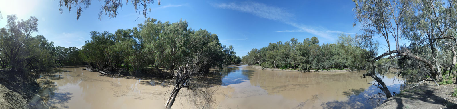
This Australian iconic river is formed by the merging of the Barwon and Culgoa Rivers.

As the river is fed by multiple basins in the upper Murray-Darling Basin, flow is more consistent than the other upstream rivers of the system. However, the river has recently run dry for months and even years at a time, making it effectively impassable by boat in many sections.

While some reports suggest that a flow as low as 20 ML/day is enough to traverse the river, a minimal flow of 100 ML/day or 200 ML/day is more realistic. Above 400 ML/day, the trip will be much more enjoyable and personally I would prefer 800 ML/day. Minor flood conditions provide a fantastic and memorable trip, but be careful as some "shortcuts" are actually distributaries!

Carefully assess the flow and speed of the water through the system before any trip. See the planning page for more details.

Riverbed without water
No flow
Riverbed with some water and weeds
Low flow, ~0 to 1 kph currents
River with high banks
Good flow, ~2 to 3 kph currents
River completely filled with water
Minor flood, ~3 to 5 kph currents

Key Waypoints

  • 1,538 km

    Darling River Head

    Wide slow flowing river lined by gum trees
    Date 21 March 2020
    Distance between locations 166 km Elevation 114 m Slope 0.07‰
    Coordinates 29° 57' 29.5" S, 146° 18' 28.4" E

    The character of the river instantly changes as you enter the Darling. It now has all of the characteristics of a major inland perennial river with broad waters and high banks.

    The Darling is most commonly started from Brewarrina (Bre for short) that is 121 km above the head of the river, a 205 km trip to Bourke.

    Walgett is the next major town upstream of Bre on the Barwon River, accessible with a 5 km paddle up the Namoi River. Walgett is 407 km above the head of the Darling, and 491 km from Bourke.

    My Personal Journey

    1st Source-to-Sea ('20)
    Date 21 Mar 2020 Flow 8.35 m 11,100 ML/day @ Warraweena
    1st Source-to-Sea ('21)
    Date 6 May 2021 Flow 11.0 m 22,000 ML/day
    Darling Double
    Date 9 Feb 2022 Flow 8.0 m 9,700 ML/day

    Great flows for all three trips with some shortcuts but still relatively high banks, especially near the start.

    2nd Source-to-Sea
    Date 27 Jun 2022 Flow 13.0 m 39,000 ML/day

    I bypassed the first section of the Darling and took the Little Bogan River instead. I can highly recommended this side trip for anyone repeating this section of the Darling in a very high flow albeit note that there are a couple low bridges to portage and one is fenced.

    Mob of 6 emus
  • 1,622 km

    Bourke

    Wharf hidden among some gum trees
    Distance between locations 84 km Elevation 108 m Slope 0.07‰
    Coordinates 29° 55' 31.8" S, 146° 41' 60.0" E
    Population 2,340 Supermarket(s) Climate
    Basin beside the toilets at the wharf
    Gauge: Bourke, BoM; WaterNSW
    Flood: minor: 9.5 m, moderate: 11.4 m, major: 12.7 m
    Flow: no flow: 3.92 m

    The old wharf is a popular spot for kids swimming in the hotter months and the grey nomads in the cooler months.

    It is only a short walk to the IGA, with a SPAR store a bit further away. Some crime issues in town.

    My Personal Journey

    1st Source-to-Sea ('20)
    Date 22 Mar 2020 Flow 5.3 m 9,400 ML/day @ Bourke
    1st Source-to-Sea ('21)
    Date 7 May 2021 Flow 9.1 m 28,400 ML/day @ Bourke

    COVID-19 halted my progress at North Bourke in 2020, and it was a relief to be able to paddle past just over a year later.

    The water was high, powerful, and fast-flowing, but fairly gentle to paddle with minimal swirls/eddies. Both weirs were washed out, and finding camping spots without having to climb the banks was fairly easy.

    kayak packed on road ready for transport
    Darling Double
    Date 10 Feb 2022 Flow 9,400 m 5.3 ML/day

    The first weir was almost washed out, and the second weir was fully submerged with a minor ripple. Muddy banks chasing the flood and the flow was slower as the water was being banked up from the flood downstream.

    2nd Source-to-Sea
    Date 28 Jun 2022 Flow 10.7 m 40,000 ML/day

    I completely bypassed the first weir on a shortcut that made me realize what this high flow would mean. I was able to take multiple shortcuts and detours, including Ryan's Lagoon, Ross Billabong, and Talowla Billabong.

    The main stem was in minor to moderate flood, so I had to search a bit harder for dry campsites, sometimes detouring slightly from the main course. The current was fast and very powerful. It did have some turbulence, but nothing too concerning.

  • 1,825 km

    Louth

    Empty street with old buildings
    Distance between locations 203 km Elevation 91 m Slope 0.08‰
    Coordinates 30° 32' 5.7" S, 145° 6' 50.8" E
    Population 43
    Untreated tank water from town hall
    Gauge: Louth, BoM; WaterNSW
    Catchment: 489,300 sq km
    Flood: minor: 8.6 m, moderate: 10 m, major: 12 m
    Flow: no flow: 1.21 m

    Shindy's Inn (02 6874 7422) is a pub that serves as a cafe and store. They stock basic supplies and you could possibly be able to organise a food run beforehand.

    My Personal Journey

    1st Source-to-Sea
    Date 9 May 2021 Flow 10.2 m 36,100 ML/day @ Louth
    Darling Double
    Date 12 Feb 2022 Flow 7.4 m 20,000 ML/day

    Great paddling conditions on or catching up to the flood peak. Less bank scrambling and less mud. All of the weirs were washed out.

    Tent in the bush
    2nd Source-to-Sea
    Date 30 Jun 2022 Flow 10.7 m 43,500 ML/day

    Similar paddling conditions on the main river as upstream. I tried exploring the western creeks but most were dry until Talyawalka Creek that I detoured down. Small fast flowing creek that slowly morphed into a large inland lake before rejoining the Darling.

  • 1,993 km

    Tilpa

    Old pub
    Distance between locations 168 km Elevation 80 m Slope 0.07‰
    Coordinates 30° 56' 12.1" S, 144° 25' 2.6" E Date Boat ramp
    Population 44 General Store
    No water
    Gauge: Tilpa, BoM; WaterNSW
    Catchment: 502,500 sq km
    Flood: minor: 9 m, moderate: 10.5 m, major: 11.5 m
    Flow: no flow: 0.18 m

    Tiny town with pub and petrol station, no supplies unless organised beforehand with the owners of the Tilpa Hotel (02 6837 3928). They do a food run about once per week.

    Bridge over river

    My Personal Journey

    1st Source-to-Sea
    Date 11 May 2021 Flow 10.7 m 32,300 ML/day @ Tilpa Weir
    Darling Double
    Date 13 Feb 2022 Flow 10.5 m 31,200 ML/day

    Great paddling conditions and easy camping.

    Multiple large birds on a tree beside the river
    2nd Source-to-Sea
    Date 2 Jul 2022 Flow 11.4 m 36,800 ML/day

    After taking a rest day on the riverbank to research and plan, I decided to attempt paddling down the eastern Talyawalka Creek. I had easy paddling and camping conditions on the main river down to the start of Talyawalka Creek.

  • 2,264 km

    Wilcannia

    Old sandstone building
    Distance between locations 271 km Elevation 66 m Slope 0.05‰
    Coordinates 31° 33' 35.6" S, 143° 22' 46.3" E
    Population 549 General Store Climate
    Taps in the council run Victory Park Caravan Park
    Gauge: Wilcannia Main Channel, BoM; WaterNSW
    Catchment: 569,800 sq km
    Flood: minor: 9 m, moderate: 9.7 m, major: 10.4 m
    Flow: no flow: -0.19 m

    An IGA in town (the Friendly Grocer 08 8091 5989). There are apparently petty crime issues so keep a watch on your gear. (RK).

    My Personal Journey

    1st Source-to-Sea
    Date 13 May 2021 Flow 9.3 m 25,700 ML/day @ Wilcannia
    Darling Double
    Date 16 Feb 2022 Flow 9.9 m 29,300 ML/day

    The flow was great and floodplains above and below the town, providing numerous shortcut opportunities.

    2nd Source-to-Sea
    Date 7 Jul 2022 Flow 2.3 m 1,160 ML/day @ Barrier Highway

    Talyawalka Creek. Wide channelled floodplains were funneled together at the highway, and from there, it was mostly a single-channel creek with waterholes until it rejoined the flooding reach of Darling. It had fairly easy paddling, camping, and navigation; however, there were a lot of fences to contend with.

    The duration and height of the flow were only just enough to allow navigation down the Talyawalka. With higher water levels, I would expect to see multiple channels that would make the navigation more interesting.

    At Wilcannia, the flow was 28,100 ML/day (9.7 m).

  • 2,569 km

    Menindee

    Maps and aerial images
    Distance between locations 305 km Elevation 58 m Slope 0.03‰
    Coordinates 32° 23' 48.8" S, 142° 24' 56.9" E Date Boat Ramp
    Population 551 General Store Climate
    Tap on fish cleaning table, and another in Burke And Wills Park if flooded
    Gauge: Menindee Town, BoM; WaterNSW
    Gauge: Menindee U/S Weir 32, BoM; WaterNSW
    Catchment: 569,600 sq km
    Flood: minor: 8.5 m, moderate: 9.1 m, major: 9.7 m
    Flow: no flow: 2.18 m

    In normal flows, water is diverted into Menindee Lakes via Lake Pamamaroo that feeds both Lake Menindee and Lake Cawndilla. A small envirnomental flow is released from Lake Menindee that feeds the lower Darling.

    The reach from Weir 32 reaches Main Weir making this section from Lake Wetherell traverable even in no flow conditions.

    Darling River Friendly Grocer (08 8091 4288) in town for supplies.

    My Personal Journey

    1st Source-to-Sea
    Date 16 May 2021 Flow 1.53 m 505 ML/day @ Weir 32

    The environmental flow was comfortable to paddle, but you are effectively paddling a small stream at the bottom of very high banks. This was higher than other trips that report more snags and weedy sections while paddling 200 ML/day.

    Darling Double
    Date 19 Feb 2022 Flow 4.3 m 10,800 ML/day

    Great paddling conditions with low banks and easy camping.

    2nd Source-to-Sea
    Date 17 Jul 2022 Flow 6.45 m 21,200 ML/day

    Exiting the Talyawalka, I paddled Tandoori Creek and Cawndilla Channel to reach the Menindee Lakes, where I rejoined the Darling at Main Weir. Paddling down, I detoured via Charles Stones Creek and exited the Darling River on Coonalhugga Creek.

    While on the main river, I had great paddling, but the large floodplains did make finding camping spots a bit harder.

  • 2,855 km

    Pooncarie

    Distance between locations 286 km Elevation 48 m Slope 0.03‰
    Coordinates 33° 23' 7.9" S, 142° 34' 1.8" E
    Population 166 General Store Climate
    Public toilets
    Gauge: Pooncarie, BoM; WaterNSW
    Catchment: 611,000 sq km
    Flood: minor: 6.8 m, moderate: 7.6 m, major: 8.7 m
    Flow: no flow: 0.63 m

    Port Pitstop Pooncarie Fuel Stop (03 5029 5267) is the only general store and fuel.

    My Personal Journey

    1st Source-to-Sea
    Date 20 May 2021 Flow 1.92 m 410 ML/day @ Pooncarie
    Darling Double
    Date 22 Feb 2022 Flow 6.0 m 13,000 ML/day
  • 3,008 km

    Ellerslie / Palinyewah

    Distance between locations 153 km Elevation 40 m Slope 0.05‰
    Coordinates 33° 50' 36.5" S, 142° 0' 45.7" E
    Gauge: Burtundy, BoM; WaterNSW

    Ellerslie is a small citrus-growing community. Likely no shops etc.

    My Personal Journey

    1st Source-to-Sea
    Date 21 May 2021 Flow 0.83 m 380 ML/day @ Burtundy
    Darling Double
    Date 22 Feb 2022 Flow 6.04 m 13,800 ML/day

    There is a fairly long reach from the weir, and the final section experienced was that of a large river with some minor flow assistance on the higher flow.

  • 3,085 km

    Wentworth

    Wide river with houseboats and a bridge
    Distance between locations 77 km Elevation 34 m Slope 0.08‰
    Coordinates 34° 6' 38.4" S, 141° 54' 12.8" E
    Population 1,248 Supermarket(s) Climate
    Tap inside public toilets
    Gauge: Murray River at Lock 10, BoM; WaterNSW
    Catchment: 906,000 sq km
    Flood: minor: 32.08 m, moderate: 32.68 m, major: 33.88 m
    Flow: no flow: 22.97 m

    Final stop before joining the waters of the Murray.

    My Personal Journey

    1st Source-to-Sea
    Date 22 May 2021 Flow 27.9 m @ Lock 10, Murray River
    Darling Double
    Date 23 Feb 2022 Flow 29.3 m
    2nd Source-to-Sea
    Date 28 Jul 2022 Flow 30.5 m 50,500 ML/day

    After leaving the Darling Anabranch, I paddled upstream against a strong current and an even stronger headwind to reach Wentworth. Ferrying across to the inside of the corners made for easier paddling on what was a decent flow down the Murray River.

    Although the weir was still operating, there was effectively no difference in water level upstream or downstream. A decent flow of around 15,000 ML/day was noted flowing down the Darling into the Murray.