Tallebudgera Creek
The Tallebudgera creek source can be found high up on McPherson Range, in Springbrook National Park between Mt Thillinman and Mt Cougal. This travels north before escaping out to the ocean on the south side of Burleigh Heads.
Calm estuary paddling can be found in the lower tidal sections, and possibly in other sections such as around the old Tallebudgera Creek Dam.
The name Tallebudgera apparently comes from the Yugambeh word "Jalubay-ngagam", which means "dingo's urine".
What to expect
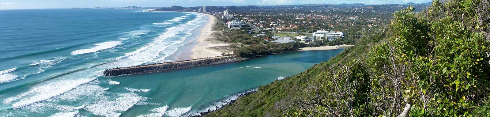
The bottom section is a wide tidal estuary with sandy beaches and is lined by parks, and it is a popular destination for families and holiday makers in summer. It quickly becomes a typical small tidal river with some mangroves around the fish habitat area. Mixed urban and parks define the upper tidal sections.
Above the tidal sections, the river becomes stepper and rockier and potentially not naviagatable. The source is found high above the beaches on the slopes of the Springbrook plateau.
Logistics
There are a few put in spots along the river operated by Gold Coast City Council.
The following are likely the better spots to put in, but there are some other locations that you can use too. Refer to the Distance Table and the Interactive Map for additional details. Parking is not an issue in general.
Boat Ramps
- 1.2 km
- Kevin Gates Park
- 1.2 km
- Murlong Crescent
- 3.6 km
- Martin Sheils Park
Kayak Carry
- 0.6 km
- Tallebudgera Creek Beach
- 3.0 km
- Tchoobey Reserve
- 5.1 km
- Schuster Park
Tides
There is likely moderate tidal influence for most trips, with some care required near the mouth (Tallebudgera Groyne) due to the current and ocean waves, and enough flow to provide a noticeable current in the lower tidal sections.
No current tide details for port: BQ108, low_offset=-4, high_offset=-3, "format=datum,days", title=Tallebudgera Creek Mouth, day-classes=col-12 col-sm-6 pb-3, container-classes=tides-block mb-3
#0: core/debug.inc, line 285, dpr()
#1: core/filters/tides.inc, line 235, print_filter_error()
#2: core/base.inc, line 299, filter_tides()
#3: core/base.inc, line 264, process_page_filters()
#4: docroot/index.php, line 41, process_request()
This could be from a parental filter such as meta
Distances
Some key locations up until Robert Neumann Park, are listed below.
| Location * | Features † | Distance (km) § | |||
|---|---|---|---|---|---|
| Leg | Total | ||||
| Tallebudgera Creek Park, Tallebudgera | 0.6 | ||||
| Tallebudgera Creek Bridge, GC Hway | 0.1 | 0.7 | |||
| L | Kevin Gates Park, Burleigh Heads | 0.5 | 1.2 | ||
| R | Murlong Crescent Boat Ramp, Palm Beach | 0.0 | 1.2 | ||
| R | Lake Awonga | 0.3 | 1.5 | ||
| L | Tchoobey Reserve, West Burleigh | 1.5 | 3.0 | ||
| L | Martin Sheils Park, West Burleigh | 0.6 | 3.6 | ||
| L | Schuster Park, Tallebudgera | 1.4 | 5.0 | ||
| R | 19 Avenue Pontoon, Elanora | 3.1 | 8.1 | ||
* Side represents either the left / port (L) or right / starboard (R) sides when facing downstream of the main river or the specified direction of travel for bays or lakes (usually anticlockwise).
† Most of the features were taken from local council pages.
§ Distances have been manually calculated from the river mouth.
Map
Explore the key locations in the map below. Most locations will have a photograph that can be seen by clicking on the icon or number in the map itself.
The map also has markers every kilometer that start at 0 at where the creek meets the ocean all the way to the source.
You may need to zoom in to see all of these kilometer markers. These do not correlate with any existing numbering system on the river.
- Lake Awonga
- Boat Ramps
- Kayak Ramp or Path
- Access Points
- Pontoon

Trip Details
Golf course
- Length
- 20.8 km
- Time
- full day
- Trip
- Return
- Technical difficulty
- Grade I
- Rating
- Type
- Tidal
- Elevation Loss
- N/A (tidal)
Quick Stats
- Length
- 32.7 km
- Navigable
- 10.4 km
- Catchment
- 97 sq km
- Elevation Loss
- Council Areas
- First Nations
- Bundjalung
© Peta Hopkins
