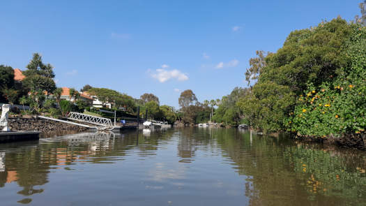
Saltwater Creek
A varied paddling experience from near virgin bush to waterfront subdivisions.
What to expect
It is a wide tidal river at the start with mangroves lining much of the northern shorelines and the southern shoreline is packed with waterfront houses. Above the anabranch / cutting you briefly follow the busy Hope Island Road, before entering mixed urban and reserve sections that include a flying fox colony at Helensvale Reserve (km marker 9.7).
A low bridge marks the end of the trip, although you could duck this and push up the riffles past the motorway bridges.
Paddling Options
The two main options are paddling the entire length of the tidal section or combining it with a trip around Hope Island.
For those wanting a slightly shorter trip, the tidal section return lengths from Jabiru Island are:
- Saltwater Cutting 13.2 km
- Rock Wall 20.5 km
Pacific Motorway
- Length
- 22.0 km
- Time
- full day
- Trip
- Return
- Technical difficulty
- Grade I
- Rating
- Type
- Tidal
- Elevation Loss
- N/A (tidal)
Hope Island
- Length
- 17.4 km
- Time
- half day
- Trip
- Circumnavigation
- Technical difficulty
- Grade I
- Rating
- Type
- Tidal
- Elevation Loss
- N/A (tidal)
Logistics
There are a couple put in spots along Coombabah Creek operated by Gold Coast City Council.
The likely best spot to put in is at the boat ramp at Jabiru Island Park. The status of River Downs Park boat ramp beside the cutting is unknown at the time of writing. Parking is not an issue usually at Jabiru Island, these are more limited at other locations.
Saltwater Creek forms an anabranch with the Coomera River, and I refer to the top cutting as the Saltwater Cutting, albeit doesn't appear to have a formal name.
The locks, canals and harbours of Monterey Keys, Oyster Cove and Lake Serenity are not open to the public.
Refer to the Distance Table and the Interactive Map for additional details.
Tides
There is likely minimal tidal influence for most trips, however a high tide will ensure easier navigation in the shallower sections.
No current tide details for port: BQ011, low_offset=116, high_offset=84, "format=datum,days", title=Saltwater Creek Entrance, key_locs_title=Tides for selected locations on Saltwater Creek for {day}, "key_locs=Saltwater Creek Cutting:141:104,Pacific Motorway:153:113", day-classes=col-12 col-sm-6 pb-3, container-classes=tides-block mb-3#0: core/debug.inc, line 285, dpr()
#1: core/filters/tides.inc, line 235, print_filter_error()
#2: core/base.inc, line 299, filter_tides()
#3: core/base.inc, line 264, process_page_filters()
#4: docroot/index.php, line 41, process_request()
This could be from a parental filter such as meta
Quick Stats
- Length
- 21 km
- Navigable
- 10.5 km
- Catchment
- 28 sq km
- Elevation Loss
- Council Areas
- First Nations
- Bundjalung
- Directions To
- Jabiru Island
River Downs Park
Distances
Saltwater Cutting is 0.6 km long.
Some key locations up until Highway bridge are listed below.
* Side represents either the left / port (L) or right / starboard (R) sides when facing downstream of the main river or the specified direction of travel for bays or lakes (usually anticlockwise).
† Most of the features were taken from local council pages.
§ Distances have been manually calculated from the river mouth.
Map
Explore the key locations in the map below. Most locations will have a photograph that can be seen by clicking on the icon or number in the map itself.
The map also has markers every 100 m for the navigable section, then every kilometer to the source, that start at 0 at where the creek meets Coombabah Creek.
You may need to zoom in to see all of these kilometer markers. These do not correlate with any existing numbering system on the river.
- Coombabah Creek
- Saltwater Creek
- Coomera River
- Jabiru Island
- Hope Island
- Saltwater Cutting
- Boat Ramps
- Bridges
- Access Point
- Pontoon
- Weir or Low Head Dams


