Pine River
Including the North and South Pine Rivers
The southern and northern branches of the Pine River begin in D’Aguilar National Park and stretch almost all of the way down to Moreton Bay, converging on the flat coastal plains to form the Pine River just west of the Bruce Highway and flowing the last 8 km as a singular river into the bay between Sandgate (Brighton) and Redcliffe (Clontarf).
Lieutenant John Oxley, the Surveyor-General of New South Wales, was the first European to see the river, giving it the name Deception River. The North Pine River was also named the Eden River at one stage, however the local common name of the Pine River was the name that stuck, referring to the Hoop Pines that were once common in the area.
There are many parks and reserves along its course although only the lower waterways are navigable.
What to expect
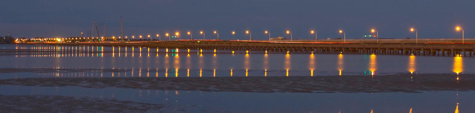
The river enters Bramble Bay, an embayment of Moreton Bay. Hays Inlet is located just to the north. This is a wide open bay with dual bridges spanning between Redcliffe and Brighton on Houghton Highway, with a fishing platform in the middle that marks about the end of the main Pine River channel into the bay. The combined span of the bridges across the lower Pine and Hays Inlet is nearly 3 km across.
There is excellent coastal paddling around both the lower Pine and Hays Inlet, with dense strands of mangroves lining the shores and is rich in various marine and bird life. Hayes Inlet is designated as a marine reserve. High nutrient loads cause water quality issues in the bay.
The Pine River forms an extensive coastal estuary and also provides excellent paddling around the Tinchi Tamba Wetlands Reserve on the banks of the Pine River. It is named after the Aboriginal words for ibis and mangroves.
The larger northern branch is known as the North Pine River. It has a tidal reach that almost extends as far as Youngs Crossing with the river decreasing in width as you head upstream. The southern South Pine River navigable section extends up to around the Gympie Rd / Railway bridges near Bald Hills.
Limited paddling upstream of both rivers other than Lake Samsonvale (North Pine Dam) and Lake Kurwongbah on Sliding Creek, a tributary of the North Pine River.
Logistics
There are a couple of boat ramps north on the bay, as well as some on the lower South and North Pine Rivers.
These are run by Moreton Bay Council or Brisbane City Council. The southern section between the South Pine River and Bramble Bay resides within the Brisbane City Council area.
Hays Inlet
South Pine
See the pages for Lake Samsonvale (North Pine Dam) and Lake Kurwongbah for logistics for accessing the lakes.
Tides
There is a tidal influence for most trips, with care required near the mouth, and enough flow to provide a small current but the extra depth is probably the biggest consideration.
No current tide details for port: BQ003, title=North Pine River Mouth, low_offset=2, high_offset=1, key_locs_title=Tides for selected locations on the North Pine River for {day}, "format=days,datum", skip-copyright, "key_locs=Bald Hills Creek:12:5,Deepwater Bend:40:12,South Pine River:44:16,Gympie Road:51:23", day-classes=col-12 col-sm-6 pb-3, container-classes=tides-block mb-3#0: core/debug.inc, line 285, dpr()
#1: core/filters/tides.inc, line 235, print_filter_error()
#2: core/base.inc, line 299, filter_tides()
#3: core/base.inc, line 264, process_page_filters()
#4: docroot/index.php, line 41, process_request()
This could be from a parental filter such as meta
Distance Table
The following distance table has some key locations. Distances are shown from Ted Smout Memorial Bridge, the river mouth.
* Side represents either the left / port (L) or right / starboard (R) sides when facing downstream of the main river or the specified direction of travel for bays or lakes (usually anticlockwise).
† Most of the features were taken from local council pages.
‡ Tide times are offset from the river mouth that are in turn offset from the Bureau of Meteorology tide tables.
§ Distances have been manually calculated from the river mouth.

Quick Stats
Pine River
- Length
- 7.8 km
- Navigable
- 7.8 km
- Catchment
- 825 sq km
South Pine River
- Length
- 42 km
- Navigable
- 4 km
- Catchment
- 241 sq km
Current Flow
- Youngs Crossing
- No Data
- Drapers Crossing
- No Data
- Dangers
- Other boats
- Council Areas
- First Nations
- Turrbal
- More Info
- QLD DAF (Caboolture Weir)
© John
Map
Explore the key locations in the map below. Most locations will have a photograph after being visited that can be seen by clicking on the icon or number in the map itself.
- Pine River
- Hays Inlet
- Saltwater Creek
- Freshwater Creek
- Bald Hills Creek
- North Pine River
- Four Mile Creek
- Yebri Creek
- Sideling Creek
- Kobble Creek
- South Pine River
- Boat Ramps
- Bridges
- Causeways
- Dam or Reservoirs
- Viewpoint
- Rapids or Rocks
- Weir or Low Head Dams
What to take
Ensure electronic devices and gear have waterproof containers / dry bags if needed.
What to wear
- Sunscreen / Chapstick *
- Sunglasses *
- Hat *
- Swimwear or shorts †
- Sun protective clothing (rashie) †
- Water shoes †
What to take
- Water
- Snacks
- Phone
- Camera
- Watch
- Sponge
- Rain jacket
- Spare clothes / Towel
Safety
- PDF (life jacket) *
- Whistle
- Paddle float ‡
- Bilge pump ‡
- Paddle lease
- Spare paddle
- Light (night paddling)
* Highly recommended (aka required)
† You should wear clothing and footwear that you can comfortably swim in.
‡ These are for self or assisted rescues where you can't easily reach the shore.
Tributaries
The major tributaries of both the South and North Pine Rivers are intermittent, needing summer run-offs to flow, although easily flooding in high rainfall events. Generally not considered navigable unless you have whitewater experience.
Major tributaries on the North Pine River include: Sideling Creek, Rush Creek, Kobble Creek, Terrors Creek, Laceys Creek and Mount Samson Creek.
Major tributaries on the South Pine River include Cedar Creek.
Hays Inlet
There are two named tributaries on Hays Inlet.
Saltwater Creek
Small creek flowing into Hays Inlet, although only the lower tidal reaches are paddable. With the tide, you should be able to reach the railway line.
The closest access point is at Pelican Park, Clontarf.
Quick Stats
- Length
- 23.5 km
- Navigable
- 8 km
- Catchment
- 52 sq km
Freshwater Creek
Small creek flowing into Hays Inlet, although only the lower tidal reaches are paddable. It has a shorter reach than Saltwater Creek, terminating at a tidal bund; an embankment to stop the tidal waters from flowing up the creek. More ambitious paddlers could try exploring upstream, however this would rely on the summer rains filling the swamp formed from the bund.
The closest access point is at Pelican Park, Clontarf.
Quick Stats
- Length
- 15.3 km
- Navigable
- 5.3 km
- Catchment
- 24 sq km
Pine River
There is a single tributary to explore on the Pine River.
Bald Hills Creek
Small creek flowing into the Pine River, although only the lower tidal reaches are paddable.
Makes for an enjoyable day trip from Deepwater boat ramp allowing you to explore the Tinchi Tamba Wetlands.
Quick Stats
- Length
- 8.5 km
- Navigable
- 3.7 km
- Catchment
- 17 sq km
South Pine River
There is a single tributary to explore on the South Pine River.
Yebri Creek
Small creek flowing into the South Pine River, although only the very lower tidal reaches are paddable.
Small detour for anyone exploring around the Pine River junction (450 m upstream).
Quick Stats
- Length
- 18.2 km
- Navigable
- 2.2 km
- Catchment
- 24 sq km
