Burpengary Creek
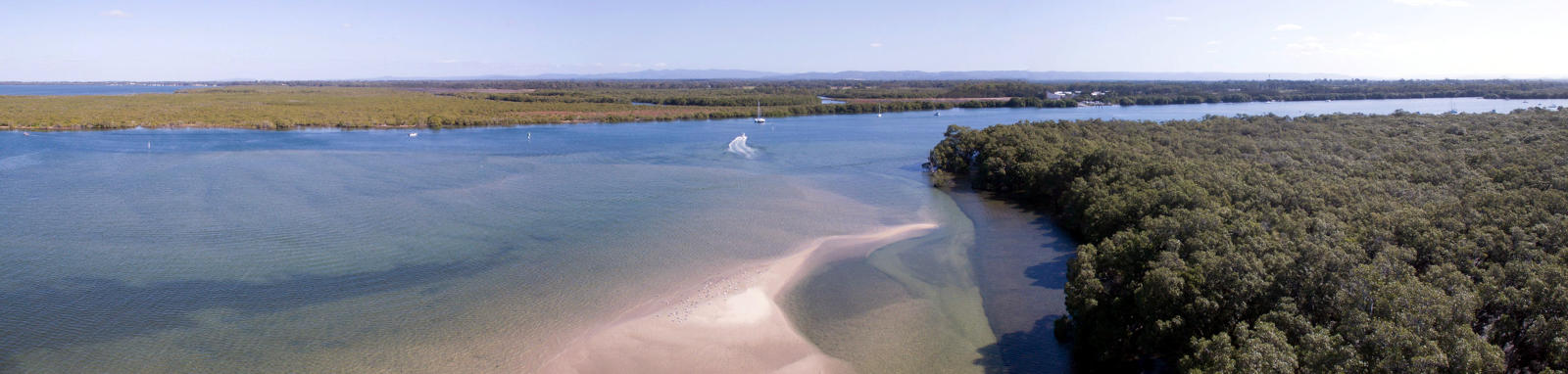
The Burpengary Creek is situated about 35 km north of Brisbane, just south of the Caboolture River. It rises in the D’Aguilar Ranges and flows in an easterly direction towards the coast, passing through Burpengary and entering Moreton Bay at Deception Bay.
What to expect
The lower Burpengary Creek is tidal and diminishes as you navigate away from the ocean, where the river becomes somewhat steeper and ephemeral D’Aguilar Ranges. While it has a small catchment, the river is prone to rapid flooding with heavy rains.
The tidal reach will create a small current that is best done with the tides to maximise the depth in the creek. The creek wonders and a number of cuttings have formed in the lower sections.
Little Burpengary Creek is about 11.3 km but only the very lower section is navigable.
Logistics
There is a single boat ramp on the creek. There are a couple other boat ramps on the bay and lower Caboolture River. These are run by Moreton Bay Council.
Tides
There is a tidal influence for most trips, with care required near the mouth, and enough flow to provide a small current but the extra depth is probably the biggest consideration.
No current tide details for port: BQ003, title=Burpengary River Mouth, low_offset=19, high_offset=6, "format=days,datum", day-classes=col-12 col-sm-6 pb-3, container-classes=tides-block mb-3
#0: core/debug.inc, line 285, dpr()
#1: core/filters/tides.inc, line 235, print_filter_error()
#2: core/base.inc, line 299, filter_tides()
#3: core/base.inc, line 264, process_page_filters()
#4: docroot/index.php, line 41, process_request()
This could be from a parental filter such as meta
Distance Table
The following distance table has some key locations. Distances are shown from the river mouth.
| Location * | Distance (km) § | |||
|---|---|---|---|---|
| Leg | Total | |||
| Burpengary Creek Mouth | 0.0 | |||
| R | Little Burpengary Creek | 2.4 | 2.4 | |
| R | O'leary Av Boat Ramp, Burpengary (Tidal) | 5.0 | 7.4 | |
* Side represents either the left / port (L) or right / starboard (R) sides when facing downstream of the main river or the specified direction of travel for bays or lakes (usually anticlockwise).
§ Distances have been manually calculated from the river mouth.
Trip Details
Lower Estuary
- Length
- 15 km
- Type
- Return
- Time
- half day
- Technical difficulty
- Open Water I
- Rating
- Elevation Loss
- N/A (tidal)
Quick Stats
- Length
- 36 km
- Navigable
- 8 km
- Catchment
- 87 sq km
Current Flow
- Dale St
- No Data
- Council Areas
- First Nations
- Turrbal
© Stephan Ridgway
Map
Explore the key locations in the map below. Most locations will have a photograph after being visited that can be seen by clicking on the icon or number in the map itself.
- Caboolture River
- Burpengary Creek
- Little Burpengary Creek
- Boat Ramps
What to take
Ensure electronic devices and gear have waterproof containers / dry bags if needed.
What to wear
- Sunscreen / Chapstick *
- Sunglasses *
- Hat *
- Swimwear or shorts †
- Sun protective clothing (rashie) †
- Water shoes †
What to take
- Water
- Snacks
- Phone
- Camera
- Watch
- Sponge
- Rain jacket
- Spare clothes / Towel
Safety
- PDF (life jacket) *
- Whistle
- Paddle float ‡
- Bilge pump ‡
- Paddle lease
- Spare paddle
- Light (night paddling)
* Highly recommended (aka required)
† You should wear clothing and footwear that you can comfortably swim in.
‡ These are for self or assisted rescues where you can't easily reach the shore.
Tributaries
Little Burpengary Creek is the only significant tributary.
