The Mallee Distance Table
Distances and times between key locations between Mildura and the Southern Ocean
A look at the blue signs along the water way
Chaos was the law of nature; Order was the law of man.

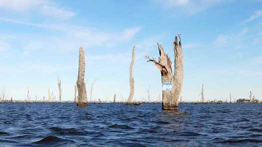
From the Hume Dam there are blue signs that were put up by the NSW and SA water authorities to mark the distance from the river mouth in kilometres.
The measured path goes around Hindmarsh Island past Goolwa and Clayton Bay before taking a fairly direct path across Lake Alexandrina and up the River Murray closely following the old path of the river from around 100 years ago. Over the years, the path of the Murray has slowly changed and many of the bends have since become islands or billabongs. A few are no longer navigable in normal flows.
The blue signs that we see today were initially put up in the 1990's by NSW Waterways Authority and Tourism SA and are currently being maintained by WaterNSW and Boating Industry Association of SA. All of the blue signs in NSW are on the NSW side of the river, while those in SA can be found on either side. I have only seen two blue marker on Victorian soil and that is near MacCabe Corner (648) and the other is on the cutting at Horseshoe Lagoon near Echuca (1720), likely placed without realising the border follows the lagoon itself.
All signs have even numbers and were originally most frequently placed around towns and less frequently in remote areas. In the early 2020s, SA had almost uniformally placed signs every 2 km along the waterway, even replacing the old marker buoys with signs on the bank. It'll be interesting to see how these faired in the 2022 floods. The only odd numbered sign seen was a fake 229 marker that is a short distance downstream of marker 230.
From Khanconam and down past Bringenbrong Bridge to Jingellic, you can find small metal markers on the banks. These have a similar function as the blue markers, but it appears that they couldn't fit on four numbers, so they dropped the two. So if you happen to see one, just add 2,000 to see how far you have to go to the mouth.
Below Wentworth there are older white signs that were put up by the Liba Liba Houseboat company in Renmark. These older signs measure the same distance to the river mouth in miles.
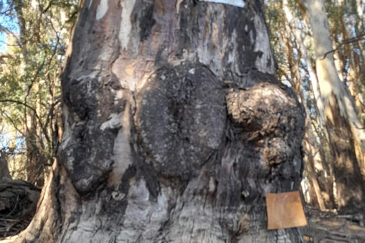
The original mile markers are much older and were carved into the red river gums downstream of Albury in the steamboat era. Very few remain today and these can be hard to find without knowing their location. These carvings were based on the first charts between Albury to Goolwa drawn by Captain Augustus (Gus) Peirce in c.1863-4 and represent the distance downstream from Albury.
I've mapped an electronic version of the blue signs on the river to use on various devices or apps. These can be downloaded in a number of formats from the links below the map. Below Hume Dam, the markers have been adjusted to match most of the blue signs found on the river with missing blue marker locations calculated and added. Many of the blue signs were significantly out in places, distances of 1.2 km to 2.8 km between the blue signs can be found.
The calculated distance was 2,190.4 km from the river mouth to the first blue sign (2224) just downstream of the Hume Dam. This was just 1.5% out and rather remarkable for the era that these were calculated. The actual distance paddled will be significantly less than 2,190.4 km as the main river course is now shorter and many paddlers will take additional shortcuts.
Above Hume Dam, a number of smaller metal triangular alpine markers have been integrated into the maps, and above the last known alpine marker, the numbering was continued using the QGIS QChainage plugin that should produce extremely consistent markers based on OpenStreetMap river track with manual corrections using various satellite images. This same track is also used to mark the river on the map below*.
Path across Lake Hume follows the original river channel as much as possible, then the state lines. This is a total of 89.6 km, while the direct path across the lake when fill is around 54.3 km.

Locations of most markers on Lake Mulwala were unknown to me but I had a rough stab at mapping these based on the single known marker 2006. The path traced from the Ovens River to the Weir is 34.5 km, but using the available shortcuts when the weir pool is filled you could cut this distance down to 18.7 km.
The track across Lake Alexandrina uses a direct line. The last marker seen was marker 72 which was fairly accurate for a direct path across and past Goolwa to the river mouth that I measured as 71.4 km. From the same point, a direct path to the river mouth via Tauwitchere Barrage (a self-operated lock) is 54.8 km and via the Ewe Island Barrage (portage and shallow if the lake is low) is 52.7 km, both will be marginally longer if done on a low tide.
Details about the how specific parts were calculated can be found on the distance details page where a summary of the main cuttings and dead arms are given with context to the actual distance to the ocean, the calcuated distance and administrative borders.
All of the markers are added to the map below. You need to zoom in to see all of these markers. A selection of these markers can be downloaded from the links below the map depending on what trip you are planning.
Download selected distance markers for your entire trip:
Download selected distance markers for various sections†:
Some approximate locations of some of the mile trees, of which I have only managed to verify the 302 mile tree at Echuca. Note that many are on the Victorian side of the river:
Footnotes
* The KML track used here has been simplified using the
Douglas-Peucker method with an ~10 m tolerance.
† Note that markers 2,437 and 2,438 (above Bringenbrong Bridge) are included in the Hume Dam to Bringenbrong section along with the markers fron Khancoban.
©2026 Alan Davison // Credit // Disclaimer