River passing through a park

Key Waypoints

Key Waypoints

  • 0 km

    Source

    River
    Elevation 668 m
    Coordinates 33° 29' 34.4" S, 149° 37' 26.4" E
    Gauge: White Rock, BoM

    The Macquarie starts at the confluence of the Fish and Campbells rivers.

    Oberon Dam provides a fairly constant water supply down the Fish River, while the Ben Chifley Dam on the Campbells River acts as a backup. When I paddled this section of the river, the Campbells River appeared more minor and to be clogged with willows.

    There is no public access at White Rock and you need to travel upstream on the Fish River for access.

    My Personal Journey

    Fish River to Bathurst

    Date 16 Jan 2023 Flow 0.82 m @ White Rock

    I was dropped off on the Fish and had a pleasant morning paddle down to Bathurst. I had a dozen or so portages due to log jams / rafts.

  • 15 km

    Bathurst

    River
    Elevation 651 m Slope 1.1‰
    Coordinates 33° 24' 42.5" S, 149° 35' 7.1" E
    Population 37,000 Supermarket(s)
    Lions Club Berry Park
    Gauge: Bathurst, BoM
    Gauge: Yarracoona, BoM; NSW WMIP
    Flood: minor: 3 m, moderate: 4.5 m, major: 5.7 m @ Bathurst
    Flow: recommended: 1 m to 1.2 m @ Yarracoona

    Australia’s oldest inland European settlement that is international famous for the motorsport on Mount Panorama.

    Most of the major supermarkets are just a short walk from Bicentennial Park.

    The gauge at Yarracoona is 76 km downstream of Bathurst and this determines the best flows for tackling the whitewater section down to Wellington.

    My Personal Journey

    Bathurst to Freemantle Bridge

    Date 16 Jan 2023 Flow 0.32 m @ Bathurst

    Nice flow but with a few log jams. Easier than upstream.

    Freemantle Bridge to Lower Mookerawa

    Date 16-19 Jan 2023 Flow 0.9 m 350 ML/day @ Yarracoona

    Flow on the low side, but pleasant kayaking in fun whitewater.

  • 188 km

    Lower Mookerawa

    lake
    Distance between locations 173 km
    Coordinates 32° 46' 7.0" S, 149° 9' 47.9" E
    General Store

    Lower Mookerawa is effectively a large caravan park with a lot of cabins that gets busy around the holidays. Two boat ramps make for easy access to / from the lake.

    My Personal Journey

    Lake Burrendong

    Date 20 Jan 2023 Flow 106% @ Burrendong Dam

    Calm flat water paddling down the reach early with a choppy finish on the more exposed sections of the lake in the afternoon.

  • 203 km

    Burrendong Dam

    River with dam wall behind it
    Distance between locations 15 km
    Coordinates 32° 40' 0.8" S, 149° 6' 31.0" E
    Gauge: Burrendong Dam, WaterNSW
    Gauge: Burrendong Dam Downstream, BoM; WaterNSW

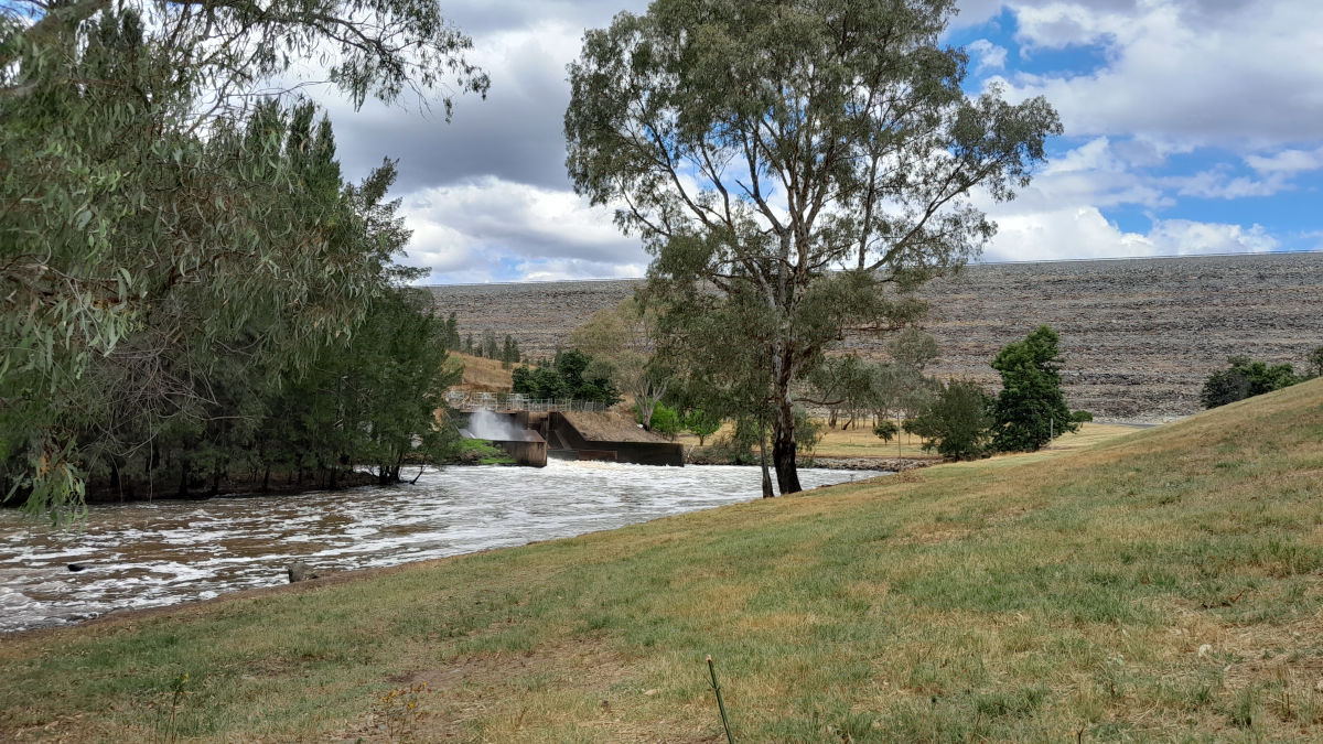
    No services at the dam other than a Water NSW run picnic area. The picnic area is locked when the park is closed.

    I was forced to portage through safe but restricted area on the very left side of the dam, dropping down a very steep bank to the foot of the dam wall and through the picnic area. I put in around 150 m downstream of the power station outlet. I had a warning of bollards in the river to reduce the release speed but I saw no evidence of these but maybe this was what I saw downstream, albeit this may have been a washed out weir or rapid. Take care as the water is fairly swift here.

    My Personal Journey

    Burrendong Dam to Wellington

    Date 20 Jan 2023 Flow 1.6 m 3,600 ML/day @ Burrendong Dam Downstream

    Around 3,600 ML/day was being released at the Dam. It made for a fast and fun trip down with minimal room for error on some of the willow-lined channels. Some short fun grade I or II rapids, most notable was going over the ford at Falls Road coming into Wellington.

  • 237 km

    Wellington

    Bridges over river
    Distance between locations 34 km Elevation 288 m
    Coordinates 32° 32' 36.2" S, 148° 56' 31.6" E
    Bus Train Population 4,000 Supermarket(s)
    Gauge: Wellington, BoM; NSW WMIP
    Flood: minor: 4 m, moderate: 9.1 m, major: 12.2 m

    There is a Woollies and Coles off Pioneer Park, 1.5 km walk from the river. Access via Bells River appears to be fenced off.

    Bus and train services to Dubbo.

    My Personal Journey

    Wellington to Dubbo

    Date 29-30 Dec 2022 Flow 1.4 m 2,600 ML/day @ Wellington

    A more sedate 2,600 ML/day was being released at the Dam when I done this leg. Still a nice level with a couple bottom scrapes on the gravel riffes.

  • 318 km

    Dubbo

    Bridge over river
    Distance between locations 81 km Elevation 255 m Slope 0.41‰
    Coordinates 32° 15' 0.7" S, 148° 35' 46.7" E
    Population 38,000 Supermarket(s)
    Tap beside picnic shelter
    Gauge: Dubbo, BoM; NSW WMIP
    Flood: minor: 5.5 m, moderate: 7.9 m, major: 11 m

    Major transport hub for northern NSW with all of the main supermarkets near the river.

    My Personal Journey

    Dubbo to Narromine

    Date 30 Dec-1 Jan 2023 Flow 1.55 m 3,850 ML/day @ Dubbo

    Great level and easy paddling, albeit a careless mistake tackling a snag in unexpectedly fast flowing water on the low farm bridge downstream of Dubbo caused my one on only capsize of the trip.

  • 391 km

    Narromine

    ramp beside river
    Distance between locations 73 km Elevation 235 m Slope 0.27‰
    Coordinates 32° 13' 33.6" S, 148° 14' 49.2" E
    Population 3,500 Supermarket(s)
    Tap beside BBQ

    Smaller town with a few services including a Coles supermarket. It could be risky to leave gear unattended at Rotary Park.

    My Personal Journey

    Narromine to Warren

    Date 2-4 Jan 2023 Flow 2.48 m 3,470 ML/day @ Gin Gin Weir

    Often skipped in lower flow conditions, I found this to be pleasant enough paddling with the only difficulties of note being a single log raft below the upper Warren Weir.

  • 526 km

    Warren

    looking up a street
    Distance between locations 135 km Elevation 201 m Slope 0.25‰
    Coordinates 31° 41' 53.2" S, 147° 50' 21.1" E
    Population 1,500 Supermarket(s)
    Caravan dump point
    Gauge: Warren, BoM; NSW WMIP
    Flood: minor: 7.5 m, moderate: 8.5 m, major: 9 m

    IGA and Spar supermarket close to the river. The last supply stop until Brewarrina, 485 km downstream that includes navigating the Macquarie Marshes.

    My Personal Journey

    Warren to Monkeygar Creek

    Date 6-9 Jan 2023 Flow 2.2 m 2,800 ML/day @ Warren
    From Warren, the flow fell to 1,750 ML/day at Marebone Weir and 1,260 ML/day at Oxley Station with water lost at both Marebone and Oxley breaks.

    Paddling became progressively more difficult as the water level fell, but the first log portages only started when the river became slightly channeled below Oxley station. Occassional low bridges can be found on this section.

    Marshes

    Skipped due to lost planning notes. No permits were being issued at the time.

    Bells Br (Carinda) to Barwon River

    Date 10-11 Jan 2023 Flow 2 m 1,260 ML/day @ Carinda (Macquarie)

    Initially channled and snaggy, the river slowly opens up and reforms into a typical Murray-Darling river with well defined banks lined by river gums and black box.

  • 882 km

    Barwon River

    looking up a river
    Distance between locations 356 km Elevation 130 m Slope 0.20‰
    Coordinates 30° 7' 46.2" S, 147° 23' 44.9" E
    Gauge: Boorooma, BoM; NSW WMIP
    Gauge: Geera, NSW WMIP

    The gauge at Boorooma is just upstream on the Barwon River, Geera is just downstream of the conflence.

    My Personal Journey

    Barron River to Brewarrina

    Date 11-13 Jan 2023 Flow 4.85 m 4,650 ML/day @ Geera

    Slower banked up water behind the flood peak downstream of Bourke. Plenty of water to paddle but with fairly high banks making camping harder. The flood mud was quickly drying in the 40 degree days and this wasn't problematic.

    My final leg although I had hoped to bypass Bre by exploring Cato Creek but I was far too late to attempt this with rapidly falling water levels.

  • 1,011 km

    Brewarrina

    weir and rapids in river
    Distance between locations 129 km Elevation 120 m Slope 0.08‰
    Coordinates 29° 57' 30.2" S, 146° 51' 26.3" E
    Population 1,100 General Store Climate
    Tap by table beside toilets near info centre
    Gauge: Brewarrina Weir, BoM; NSW WMIP
    Flood: minor: 6.4 m, moderate: 7 m, major: 9.5 m
    Flow: no flow: 1.66 m

    Known for the Brewarrina Fish Traps, Bre is the first town along the Barwon River downstream. There is a Foodworks and local general store in town.

    Free WiFi on the main street, swimming pool and camping ground if you aren't on Telstra network.

    A detour via Cato Creek will bypass Brewarrina. The Baron River needs a flow of 24-27,000 ML/day or more for the Cato to flow.

  • 1,216 km

    Bourke

    Wharf hidden among some gum trees
    Date 7 May 2021
    Distance between locations 205 km Elevation 108 m Slope 0.06‰
    Coordinates 29° 55' 31.8" S, 146° 41' 60.0" E
    Population 2,340 Supermarket(s) Climate
    Basin beside the toilets at the wharf
    Gauge: Bourke, BoM; WaterNSW
    Flood: minor: 9.5 m, moderate: 11.4 m, major: 12.7 m
    Flow: no flow: 3.92 m

    This last stop before committing to paddling the upper Darling.