")
")
")
Key Waypoints
A quick reference to many key locations along the route
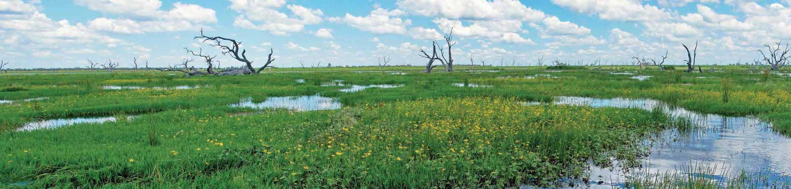

Known as “the Marshes”, this large, semi-permanent wetland filters the water of the Macquarie River in central northern New South Wales. The Macquarie Marshes Nature Reserve and State Conservation Area cover 21,927 hectares, with the area of marsh expanding up to 200,000 hectares. The Marshes contain a range of wetland types from water couch grasslands, reedbeds and river red gum forest, to less frequently filled wetlands of coolabah and black box woodland.
The Macquarie River enters its floodplain at Narromine, and from here downstream the river channel capacity declines. From here much of the water from the mainstem will be diverted into effluent creeks and streams, especially in flood where it will flow into the Bogan River.
About 50 km downstream of Warren, the Marebone Weir represents the start of the extensive River Red Gum (Eucalyptus camaldulensis) woodlands where the mainstem of the river breaks down into numerous creeks, channels. These form the wetlands known as the South Marsh. These flows eventually rejoin to reform the Macquarie River, however it is best described as a small channel, or as Sir Thomas Mitchell put it ‘a muddy ditch one might step across’. In good flows, this channel will flow into the North Marsh where the system once again expands out over the floodplains.
In the South Marsh, the main flow appears to have shifted from the Macquarie River into Monkeygar Creek through a process known as channel avulsion in a relatively short period between c. 1800 to 1960. This likely gets most of the flow. Much of the reeds of the South Marsh were reported to have gone by 1960, the likely location where Oxley had encountered impenetrable reed beds in 1818.
In the North Marsh, the Bora Channel appears to be the primary channel as the other channels seem to disappear into the reeds. The North Marsh Bypass channel that was built in 1972 allows water to get diverted around the system to ensure some water gets to residents living downstream of the Marshes.
From a paddling perspective, it is difficult to know if it is possible to navigate.
Of the trips reported in the Bremers Murray-Darling Journeys, Brown and Byrne appeared to get the closest of a successful trip through the Marshes in 1984. Others either terminated their trip here or bypassed the swamp altogether.
Brown and Byrne took Monkeygar Creek and got a lift for 3 km to Bulgeraga Creek that they managed to paddle down into the Bora Channel and then the Macquarie River again. It took them 9 days to traverse the 271 km section from Mt Harris to the Barwon River, almost half their daily rate compared to the above section below Lake Burrendong. They struggled with snags below Marebone Weir (Mt Harris), barbed wire fences around Monkeygar Creek, then more reeds and snags all the way down to the Barwon River.
Watching a high flow event in May 2022, the following flows were seen:
A major flood event will inundate 150,000 hectares or more of the Marshes. Once the floodplain is fully inundated, excess water will spill over into the Bogan River.
The recent flood events from 1973 where the water level at Oxley rose above 3.7 m.
| Flood Event | Area Inundated | Height Oxley Gauge | Days |
|---|---|---|---|
| Nov 1973 | 3.89 m | 206 | |
| Aug 1974 | 3.82 m | 161 | |
| Nov 1976 | 3.77 m | 17 | |
| Sep 1978 | 150,000 hectares | 3.78 m | 87 |
| Aug 1984 | 3.70 m | 6 | |
| Aug 1989 | 3.72 m | 65 | |
| Aug 1990 | 228,000 hectares | 3.87 m | 63 |
| Aug 1998 | 187,000 hectares | 3.74 m | 39 |
| Dec 2000 | 174,000 hectares | 3.81 m | 34 |
| Jan 2011 | 3.71 m | 37 | |
| Aug 2016 | 3.96 m | 21 |
Several threatened bird species breed in the Marshes including magpie geese, brolgas, freckled ducks, Australian painted snipes and Australasian bitterns. Cormorants, ducks, grebes, spoonbills and herons also breed in large numbers during larger river flows into the Marshes.
")
River Red Gums, Black Box and Coolibah are the dominant trees. They all require flooding for their seeds to germinate, however only the red gums can survive long periods of inundation, up to 18 months. All three species can survive long dry periods, although River Gums are most susceptible to the dry, needing access to groundwater that is not overly saline.
")
")
")
")
The following smaller plants help to keep the wetlands healthy by trapping water in the channels, but as a paddler will make progress very slow, even impassible:
")
")
")
Final footnote is that attempts to get more information have resulted in either ghosted calls or negative responses. I'm fully confident that an experienced crew would be able to do this with a flood flow feeding the system, however I now expect that the access will be blocked during these periods to protect the nesting spots of the more endangered bird species even though these species generally don't nest along the flowing channels.
An alternative from the channels across to Marthaguy may be possible but this will almost certainly be significantly harder.

©2026 Alan Davison // Credit // Disclaimer