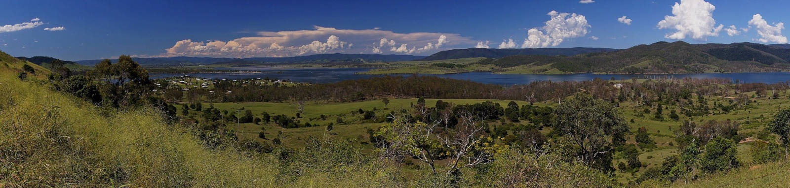
Lake Somerset
Somerset Dam
Somerset Dam is one of the region’s oldest and largest water storages in South East Queensland.
The lake is popular with fishermen and recreational activities in summer. The upper half has a 6 knot speed limit and could be a quieter spot to avoid the summer holiday crowds.
What to expect

It has a narrow profile that is never much more than 1 km wide. The lake is approximately 25 km long from the dam wall to the head of the lake at Villeneuve, yet has over 150 km of shoreline to explore, excluding the reach of the lake up various tributaries.
While it is flatwater paddling, it is a fairly large body of water so conditions can get rough in stormy or windy weather.
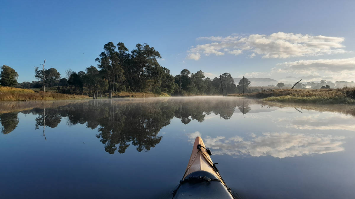
Early morning fog can also be an issue; make sure you have some form of navigation aid and a whistle in these conditions.
The dam is nestled in the forested foothills, with farmland around most of the foreshore. The main exception being the coves around Wyangy Creek that are mostly forested apart from the cleared private camping areas.
Many of the creeks and coves have wetland areas, with a high volume of aquatic weeds such as water lilies, water hyacinth, salvinia and water lettuce, to name a few. High numbers of water birds can be found in these areas, though the smaller waders prefer shorelines clear of these weeds.
Even at 80% capacity, there is a long reach up some of the creeks, particularly up Kilcoy and Sandy Creeks, but the longest is the Stanley River itself, where I was able to traverse 15.5 km up from Westvale Road, almost all the way to Stony Creek. Some of the larger tributaries are covered below.


Logistics
The dam and recreation facilities are open to the public seven days a week at the time of writing, from 5:30am to 6:30pm (September – April) and 6:00am to 5:30pm (May – August).
There are three main put-in spots around the dam. Starting from the dam wall and heading north you have the choice of three boat ramps:
At 80% fill, what appeared to be the paved section of Westvale Road Boat Ramp was high and dry, but you could still access the lake with a small gravel ramp that had a bit of a drop-off. An easy put-in for paddle craft directly from the shoreline. Both of the paved sections of the other ramps were still in the water.
When coming from the city, the Warrego (M2) or D'Aguilar (85) highways are the normal options, but you could be used with the scenic and winding road up and over Mount Glorious.
There are no public transport options.
Features and facilities
Primary point of truth for the lake should be the official SEQWater published Location maps and guides.
The following is a rough guide about different locations around the lake. Since the lake levels do fluctuate, distances could vary considerably as the water level drops. The taps are all marked as non-potable water.
| Location | Features † | Distance ‡ | ||
| The Spit | Kirkleagh | |||
| Dam Spillway | 2 km | 12.7 km | ||
| The Spit | - | 11 km | ||
| Kirkleagh | 11 km | - | ||
| Westvale Road | 21.5 km | 10.2 km | ||
| Neurum Rd Bridge, Villeneuve | 25.2 km | 13.9 km | ||
† Most of the features were taken from SEQWater published Location maps and guides.
‡ Distances are approximate only and are based on roughly staying near the shoreline while crossing most of the lakes sidearms. These
crossings may be up to 1 km wide.
Access Restrictions
Access is restricted directly above and below the dam wall.
Refer to the SEQWater Lake Somerset guide for up to date information.
Map
Explore the key locations in the map below. Most locations will have a photograph that can be seen by clicking on the icon or number in the map itself.
- Somerset Dam
- Neurum Rd Bridge
- Boat Ramps
What to take
Ensure electronic devices and gear have waterproof containers / dry bags if needed.
What to wear
- Sunscreen / Chapstick *
- Sunglasses *
- Hat *
- Swimwear or shorts †
- Sun protective clothing (rashie) †
- Water shoes †
What to take
- Water
- Snacks
- Phone
- Camera
- Watch
- Sponge
- Rain jacket
- Spare clothes / Towel
Safety
- PDF (life jacket) *
- Whistle
- Paddle float ‡
- Bilge pump ‡
- Paddle lease *
- Spare paddle
- Light (night paddling)
* Highly recommended (aka required)
† You should wear clothing and footwear that you can comfortably swim in.
‡ These are for self or assisted rescues as there are places that you can't easily swim back to the shore.
Wildlife
There is a wide variety of birdlife on the lake. Darters, Cormorant (often large flocks), Egrets, Pelicans, Coots, Ducks, Grebes and Swans are common on the water and a large array of other species can be seen along the shoreline.
You could be lucky and see some turtles before they dive into the water, as well as getting a sudden visit by the large and protected Australian Lungfish coming up for air. Native mammals are less frequent, but occasional kangaroos can be seen along the water's edge


Quick Stats
- Lake / Reservoir
- Lake Somerset
- Dam / Weir
- Somerset Dam
- Waterway
- Stanley River
- Shoreline
- 167 km
- Navigable
- 103 km
- Capacity
- 286 GL
- Flood Mitigation
- 524 GL
- Catchment
- 1,340 sq km
- Area
- 41.2 sq km
- Dangers
- Wind waves, fog
- Council Areas
- First Nations
- YuggeraWaka WakaJinibara
- Directions To
- The Spit
Kirkleagh
Westvale Road
Tributaries
Oaky Creek
Small inlet opposite Kirkleagh boat ramp. Small but nice wetland areas with a fairly short navigable section up the creek itself.
It's about a 2.5 km paddle across the lake to explore this small area.
Quick Stats
- Length
- 19 km
- Navigable
- 1 km
Kilroy Creek
The first half of Kilcoy Creek is really just a narrow arm of the lake before it contracts and passes through open farmland. As you near Kilcoy where the creek quickly narrows and banks rise. Lots of turtle sightings as well as some water dragons. I had to stop about 1 km from the township due to fallen trees but it was already getting a bit too shallow to paddle.
You could extend the 21 km paddle by exploring the short navigable sections of Oaky and Sheep Station Creeks (depending on the height of the lake).
The best access is via Kirkleagh, but a longer paddle from Westvale will make for a more challenging day (up to 33 km return or slightly shorter with shortcuts if the lake is full).

Quick Stats
- Length
- 33 km
- Navigable
- 8.5 km
Sandy Creek
The first half of Sandy Creek is a wetland area of the lake before it contracts upstream and passes through mixed woodlands and farmland.
Accessible via Kirkleagh (6.7 km) or Westvale (4.1 km). The latter is recommended for about a 20 km return trip if you push up the creek when the lake is full.
Quick Stats
- Length
- 20 km
- Navigable
- 2 km
Stanley River
Reach up the Stanley River had three distinct characteristics, starting with extensive wetlands, before traversing through farmlands with low banks. The final third of my trip had forested verges with high banks with diverse bird life.
With the lake at 80% fill, I almost got to Stony Creek, making for a 30 km return trip. It is a sign that you are nearing the limits of the navigable section once it starts to get shallow, with snags and possibly running water. I did one log portage only to be stopped 100 m further on. There are booms at Neurum Rd Bridge and another upstream to help reduce the inflow of weeds into the lake.
This was my favorite trip done on the lake, with a platypus and rakali (water rat) sighting to boot.
Running east-west, remember your sunnies if heading out early or late in the day!
Upper Stanley
From Westvale Road
- Length
- 75 km
- Navigable
- 15 km
