Caboolture River
The Caboolture River, located approximately 35 km north of Brisbane, originates in the D’Aguilar Ranges. It gracefully flows eastward toward the coast, passing through Caboolture before emptying into Moreton Bay near Deception Bay, close to the township of Beachmere.
What to expect
The lower Caboolture River is tidal up to the Caboolture Weir, a somewhat redundant tidal barrage. The weir offers excellent paddling opportunities on the weir pool.
As you venture upstream, the river becomes steeper and more ephemeral. Despite its relatively small catchment area, the Caboolture River is prone to rapid flooding during heavy rain events.
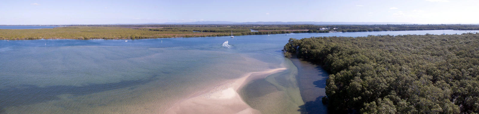
At the river mouth, the estuary can stretch up to 400 m wide. However, as you continue upstream, the width gradually reduces. Around King John Creek, it narrows to approximately 100 m, and down to 50 m at Caboolture.
The tidal reach will create a moderate current that is best paddled with the tides.
Paddling Options
If you’re looking for shorter paddling adventures, consider starting from one of the convenient put-in locations along the river.
For those seeking more extensive exploration, you can embark on longer trips along the main tidal section. Keep in mind that a full round trip from Deception Bay to the weir, covers over 40 km.
Remember to check the tides and plan your paddling accordingly.
Lower Estuary
- Length
- 8.4 km
- Type
- Return
- Time
- half day
- Technical difficulty
- Open Water I
- Rating
- Elevation Loss
- N/A (tidal)
- Notes
- Paddling down to Deception Bay adds about 3 km to the trip.
Full Lower Caboolture
- Length
- 41 km
- Type
- Return
- Time
- full day
- Technical difficulty
- Open Water I
- Rating
- Elevation Loss
- N/A (tidal)
Bin Chicken Island
- Length
- 5 km
- Type
- Return
- Time
- half day
- Technical difficulty
- Open Water I
- Rating
Caboolture Weir
- Length
- 6.2 km
- Type
- Return
- Time
- half day
- Technical difficulty
- Open Water I
- Rating
Logistics
There are a couple boat ramps near the mouth and a kayak ramp just above the weir at Caboolture, all maintained by Moreton Bay Council.
For those paddling solo trying for a longer trip, Translink provide a couple of options:
- Bus Route 652 runs between Caboolture and Beachmere.
- Bus Route 660 connects Caboolture and Deception Bay but is a fair way south and away from the bay.
Tides
There is a significant tidal influence for most trips, with care required near the mouth, and enough flow to provide a noticeable current in the tidal sections that are best paddled with the current.
Tidal flows can peak around 2-3 kph in places.
No current tide details for port: BQ003, title=Caboolture River Mouth, low_offset=18, high_offset=6, "format=days,datum", day-classes=col-12 col-sm-6 pb-3, container-classes=tides-block mb-3
#0: core/debug.inc, line 285, dpr()
#1: core/filters/tides.inc, line 235, print_filter_error()
#2: core/base.inc, line 299, filter_tides()
#3: core/base.inc, line 264, process_page_filters()
#4: docroot/index.php, line 41, process_request()
This could be from a parental filter such as meta

Quick Stats
- Length
- 49 km
- Navigable
- 27 km
- Catchment
- 350 sq km
Current Flow
- Caboolture
- No Data
- Short Street
- No Data
- Riversleigh Road
- No Data
- St Smith (mouth)
- No Data
- Dangers
- Other boats
- Council Areas
- First Nations
- Turrbal
- More Info
- QLD DAF (Caboolture Weir)
- Directions To
- St Street (Beachmere)
Uhlmann Rd (Burpengary)
Caboolture Arboretum
© Stephan Ridgway
Distance Table
The following distance table has some key locations. Distances are shown from the river mouth.
* Side represents either the left / port (L) or right / starboard (R) sides when facing downstream of the main river or the specified direction of travel for bays or lakes (usually anticlockwise).
§ Distances have been manually calculated from the river mouth.
Map
Explore the key locations in the map below. Most locations will have a photograph after being visited that can be seen by clicking on the icon or number in the map itself.
- Caboolture River
- King John Creek
- Wararba Creek
- Burpengary Creek
- Boat Ramps
- Kayak Ramp or Path
- Weir or Low Head Dams
What to take
Ensure electronic devices and gear have waterproof containers / dry bags if needed.
What to wear
- Sunscreen / Chapstick *
- Sunglasses *
- Hat *
- Swimwear or shorts †
- Sun protective clothing (rashie) †
- Water shoes †
What to take
- Water
- Snacks
- Phone
- Camera
- Watch
- Sponge
- Rain jacket
- Spare clothes / Towel
Safety
- PDF (life jacket) *
- Whistle
- Paddle float ‡
- Bilge pump ‡
- Paddle lease
- Spare paddle
- Light (night paddling)
* Highly recommended (aka required)
† You should wear clothing and footwear that you can comfortably swim in.
‡ These are for self or assisted rescues where you can't easily reach the shore.
Tributaries
Its major tributaries include Wararba, Sheep Station, King John and Lagoon Creeks.
