Bremer River

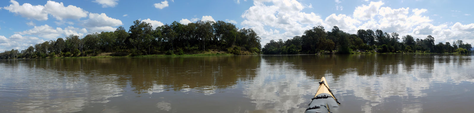
From its source in the Main Range, the Bremer River is a small, often non-flowing, stream that travels through 76 km of farmland before turning into a tidal river as it meets Ipswich. It is the last 24 km section of riverway that provides a quiet and tranquil kayaking trip for paddlers of all levels of ability.
Wildlife is common, especially Water Dragons, Egrets, Herons, Cormorants, Kingfishers, Ducks, and Moorhens. Usually you also see some turtles sun-baking on logs if you are quiet, as well as Sea-Eagles, Corellas, Cockatoos, Ravens, Spangled Drongos and many other bird species too.
What to expect

The river is up to 100 m wide and very deep in places, especially towards the confluence with the Brisbane river. Being tidal, it pays to plan ahead to catch the right flow for the most enjoyable trip, especially when doing the upper sections to avoid submerged rocks. The tidal nature of the river is also the cause of the thick sticky mud that you should try to avoid.
Tidal flows peak at around 2 to 3 kph, but if needed you can hug the inside banks to avoid some of this current. The tidal flow could cause some concern for inexperienced paddlers around the small island 2 km upstream of Ipswich central. This constricts the mid-tide currents into a narrow passage that significantly speeds up the flow. If required, traverse diagonally across the main channel from one eddy (still water zone) to the other.
There is one small rapid below Shapcott Park that changes character with the tide. During high tides this can be paddled directly across but becomes a short portage on low tide. See the photos below that were taken two hours apart below, both looking upstream. The first has a mere trickle and the latter has a strong current running upstream!
Generally the rest of the river below this point is fairly free of rocks excluding a small section of Cribb Park where there is some shallow or exposed bedrock on the right side of the river when facing downstream. Staying left along the northern side easily avoids this, although there is a narrow channel to the right of the rocks.
A small island constricts the flow forming a choke about halfway between Shapcott Park and Ipswich CBD. An increased flow around 5 kph here can be seen during mid-tides that may require you to ferry between the eddies (still waters) to get past.
Generally there are no other features of great concern.


Logistics

There are generally only three put points along the river in parks that are all run by the Ipswich Council. Park gates may be locked from 6pm - 6am.
- Shapcott Park Canoe Ramp
- This provides the best access to the upper sections above Coalfalls.
- Cribb Park Boat Ramp
Common access point in the heart of Ipswich. Take care launching from the boat ramp as this can get slippery.
The park used to have a pontoon that was part of the Ipswich Canoe Trail, however this was lost to flooding. There are plans to replace the platoon sometime, albeit there are funding issues that have so far prevented this from happening.
- Joseph Brady Park, Brisbane River
- Small boat ramp can be found slightly upstream on the Brisbane River. This can get muddy, especially with a low tide.
Hancock Bridge could provide an alternative access point to the northern side of the river in Coalfalls, however it would likely be a difficult put-in / take-out point.

Quick Stats
- Length
- 101 km
- Navigable
- 77 km
- Council Areas
- Scenic Rim sections are not navigable.
- First Nations
- Yuggera
- Directions To
- Shapcott Park
Cribb Park
Joseph Brady Park
Tides

My personal preference is to stay with the high tide waters as much as possible. For one way trips I would plan to head upstream with the incoming tide and downstream with the outgoing tide to get assistance with the current.
Tidal flows can be strong, so aim to plan your trip to paddle with the tide. It takes time for the tides to push up the valley, the high tide at Shapcott Park is 3 hours after the high tide at Brisbane River mouth! Refer to the calculated tide table below and Distance Table for tidal offsets for most locations in the lower river.
Note the slight discrepancy between the high and low tide times. An incoming tide will push up the river faster than a receding tide.
No current tide details for port: BQ138, title=Bremer River Entrance, low_offset=124, high_offset=112, key_locs_title=Tides for selected locations on the Bremer River for {day}, "key_locs=Warrego Highway:145:120,Bundamba Creek:147:122,Cribb Park Boat Ramp:153:125,Shapcott Park Canoe Ramp:158:128", container-classes=tides-block mb-3#0: core/debug.inc, line 285, dpr()
#1: core/filters/tides.inc, line 235, print_filter_error()
#2: core/base.inc, line 299, filter_tides()
#3: core/base.inc, line 264, process_page_filters()
#4: docroot/index.php, line 41, process_request()
This could be from a parental filter such as meta
As an aside, the HAT tide is 65 cm higher than the high tide where I took most of the pictures for this post! These were taken with a tide height of 2.09 m, which is slightly below the average high tide height seen on the river.
Distance Table
| Location * | Features † | Tides ‡ | Distance | Total | |||
| Low | High | ||||||
| Source | n/a | n/a | 0 km | 0 km | |||
| Don Livingstone One Mile Bridge | n/a | n/a | 77.0 km | 77.0 km | |||
| Rail Bridge | 3:18 | 2:45 | 1.9 km | 78.9 km | |||
| R | Shapcott Park Canoe Ramp | 3:15 | 2:42 | 1.2 km | 80.1 km | ||
| Hancock Bridge | 3:15 | 2:42 | 0.7 km | 80.8 km | |||
| Bradfield Bridge | 3:12 | 2:41 | 3.4 km | 84.2 km | |||
| David Trumpy Bridge | 3:12 | 2:41 | 0.3 km | 84.5 km | |||
| L | Cribb Park Boat Ramp | 3:11 | 2:40 | 1.8 km | 86.3 km | ||
| R | Bundamba Creek | 3:10 | 2:39 | 6.6 km | 92.9 km | ||
| Warrego Highway Bridge | 3:02 | 2:34 | 3.1 km | 96.0 km | |||
| Brisbane River | 2:44 | 2:29 | 5.3 km | 101.3 km | |||
| L | Joseph Brady Park | ||||||
* Side represents either the left / port (L) or right / starboard (R) sides when facing downstream.
† Most of the features were taken from Ipswich City Council pages.
‡ Tide times are offset from the Brisbane Bar (27° 22' 42.6" S, 153° 9' 45.4" E). BoM tide tables.


Map
Explore the key locations in the map below. Most locations will have a photograph that can be seen by clicking on the icon or number in the map itself.
- Source
- Don Livingstone One Mile Bridge
- Rail Bridge
- Hancock Bridge
- Bradfield Bridge
- David Trumpy Bridge
- Bundamba Creek
- Warrego Highway Bridges
- Boat Ramp
- Kayak Ramp or Paths
- Viewpoints
- Rapids or Rocks
- Water Feature
What to take
Ensure electronic devices and gear have waterproof containers / dry bags if needed.
What to wear
- Sunscreen / Chapstick *
- Sunglasses *
- Hat *
- Swimwear or shorts †
- Sun protective clothing (rashie) †
- Water shoes †
What to take
- Water
- Snacks
- Phone
- Camera
- Watch
- Sponge
- Rain jacket
- Spare clothes / Towel
Safety
- PDF (life jacket) *
- Whistle
- Paddle float ‡
- Bilge pump ‡
- Paddle lease
- Spare paddle
- Light (night paddling)
* Highly recommended (aka required)
† You should wear clothing and footwear that you can comfortably swim in.
‡ These are for self or assisted rescues where you can't easily reach the shore.
Wildlife
The Bremer River has a number of distinct habitats for wildlife along its length, but only two are accessible via the water. These are the wooden bush fringes
Birds
Birdlife is by far the most common on the river unless you are staying put fishing. The rather long list are species that often made an appearance for me while I was on the water and are likely to be only a small fraction of the birds known to frequent the area.


Reptiles
Along with the birdlife, Water Dragons were common especially in the upper freshwater sections and Brisbane Short-necked Turtles in the lower tidal sections.


Pests and Weeds
Unlike lower sections of the river that have dense mangrove linings, the upper sections do not hide the weedy plant species that are common along the river that include the following:


Tributaries
The only main tributary of any great interest is Bundamba Creek.
Bundamba Creek
On high tide, this makes for a cooling side-trip as you escape the sun into the shade of the overhanging tree canopies. I got about 2 km up before being turned around due to a fallen trip across the river. I had no issues navigating my 5.2m kayak up the creek until this point.


