Murray Darling Depression
Key flora and fauna found along the lower Murray
Daily ramblings from my time on the Murray.
I completed the upper section to Bringenbrong in a roundabout way in Dec 2020 and the rest of the river nearly 12 months later.
This break at Bringenbrong was originally only planned to be three or four days, just enough time to drive back to Queensland to switch kayaks. As fate would have it, the simple boat swap got delayed due to a fire, car accident, QLD flood and then COVID.
I wasn't even planning to kayak the lower Murray this summer. I had been avoiding this because of the border closure issues with covid and partially in case if I managed to get a chance at paddling the Darling if it rained in QLD. With a period of stability with COVID and a disappointing la Niña I started looking at some of the other smaller rivers. After finishing the Murrumbidgee River I gave up on the la Niña bringing rain to QLD and I decided I had just enough time to tackle the Murray.

Finally free to go. One last check over the gear and I'm ready to head off. I decided to go on one practice run wearing my pack with eight days worth of food and the boat to ensure things were ok to go.
F@#$%, final complete tally of the gear was 35 kg without water. I can comfortably man handle it and wear it around, but I know it is too heavy and a test walk of 500 m validates that. I've been training with a much lower weight of 25 kg I'm not going to be able to complete the trek to the source and Poplars in one trip... Time to reassess things.
Google doesn't come to my aid. I know it's about $130 for a shuttle from Jindabyne to Thredbo, that's on a short trip on a tarmac road, what would a ride into the middle of nowhere on a 4wd cost!? It's too late to start trying clubs for someone to hitch a ride with, it looks like I'm going to need two trips in. Deflated, I sit down and contemplate if things are still feasible...
I wake up with the Nike marketing moto and decide to just go with the two trips to walk the gear in and not to delay the trip any more knowing that the area dries up over summer. Quickly checking, the pack weight with the boat is 26 kg without water, I can definitely do it.
Quickly visiting my brother and sister on the way down turns into a half-day work detail volunteering to help my sister setup some semi-permanent tents for her nature conservation project. It's getting close to 5pm and I've only just crossed into NSW. This could be a long trip down. I put my trust in my navigation app and blindly head off following backroads south. Random rest area at 1am (2am AEDT) for the night.
Up with the sun rising, I continue down to Thredbo, arriving around 3:30pm (4:30pm AEDT) the following day.

Original plans were to do a single day hike around the circuit, but with all of the delays I was itching to get moving. Quickly checking with the info office about any possible crime issues (reg. car packing in random places) and policies regarding bush camping, I head off. There are apparently very limited issues with crime there, and I intentionally had allowed the car to look very dirty to make it look cheap. Backcountry camping is also permitted with some restrictions.
With a light overnight pack with a bivy & one day's food, I start the walk up at 5:10pm (all times now in AEDT). With the lifts closed, the trails are fairly deserted and the day is pleasantly cool but with an overcast sky casting a moody light. With the church bells randomly ringing in the distance, the old burn damage and the cry of distant crows it feels slightly apocalyptic, I can't help but think of the GoT episode of Targaryen and King's Landing (spoilers / nsfw). It was strangely foreboding...

The tramp up is fairly easy but steep. I can see why there are no footprints heading up the climb, just down. I pass 4 groups heading down, before getting to the plateau. I seem to have Mount Kosciuszko all to myself and take in the views of the last remaining snow caps and mountain meadows filled with the early summer flowers. The crispness in the air reminds me of home, and I can't remember the last time that I couldn't recently smell smoke after our horror fire season in QLD / Nth NSW.
Nearing the top and getting close to sunset, I see a Sydney couple camping on the main ridge towards Mueller's. They join me and another cyclist to watch the cloudy sunset. In the twilight hour, I descend down the ridge to make camp and cook a meal.

The bivy works well but not so well with the summer weight sleeping bag with the passing clouds drifting across the ridgeline. Convection heat loss was considerable and I regretted only taking a single underlayer up. I slept fully clothed. I first woke up around 2am, unsure if it was the cold, moonlight or random flash from meteors waking me. In the distance I see someone trekking around Mt Townsend (2,209 m Australia's second highest peak), and wonder why they are up and about at this time. Sunrise finally started around 5:15am and I headed for the summit. Low and behold, I find a large group of star gazers at the summit, maybe 45 people? I was glad I decided to follow the regulations and not bivy right on the summit itself! Before the sun had a chance to rise, the star gazers made their way off the summit and I again had Koscie to myself. Using an artic trick of boiling water the night before for breakfast using a thermos, I sat down and watched the sun rise with a hot cuppa and even some hot porridge.
After an hour or so, I start the journey down. I passed a pair of Swiss tourists that were a bit perplexed seeing another walker on the summit trail at 6am, and a few more as I descended down the Dead Horse Gap Trail. True to its name, there was a large mass of dead Snow Gum Trees creaking and grinning in the wind and crows squawking in the distance, but there was also a lot of life as the gums were regenerating from their base. I saw my first snake of the journey, a full grown alpine copperhead basking in the sun just off the track. True to their gentle nature, it quickly scurried off before I got close.

After arriving back at Thredbo, I made a trip down to Tom Groggin. There seems to be enough water flowing, so I take that as a greenlight and head back to the Cascade Trailhead and get ready to packhorse the kayak in. With the kayak and 7 days food, I estimate that I've got about 26 kg without water, 28 kg with. It takes a bit over 3 hours to get to the Cascade Hut which is about 10 km along the trail. I feel absolutely stuffed when I get there. I am not sure if it was the heat, poor night's sleep or simply the additional 3 or 4 kg in the pack, but I sit down and zone out for an hour to rest before setting up camp for the night. Some weekend warrior hikers and anglers that I was chatting to at the trailhead were the last humans that I've seen, and the place seems to be truly remote compared to the summit experience last night. Around the creek across the plain a family of brumbies can be seen munching away. Graceful animals, I can see why some people like them, but I'm also wondering why there is so much horse scat around.

After waking up with the sun, I decided to sleep in a bit for the long walk ahead. I finally arose at 8am before leaving at 9am. I soon see another team of wild horses, then again a couple more at Tin Mine Huts, and more on the trails. Other than the constant snorting of horses, the day was fairly uneventful, but the lack of water is starting to become apparent. I found a couple of litres was not really enough, and most of the streams are either dry or trampled into bogs. A seep going across the road before the snow gum trail was gratefully utilised. I continue on and make camp a km before the Pilot Creek Trailhead. The body is not really liking being a pack horse! I've definitely consumed too much water and realise I'll just have enough for brekky and will likely need to get to the Murray to get more. It's only 7 km as the birds fly so I'm not overly concerned.
With signs of horses everywhere and piles of scat up to a half metre high, these cute additions to the environment are not looking so cute anymore. Once you start to look closely it soon becomes apparent that these majestic animals are in fact really destroying the alpine environment. There are tracks everywhere and most of the small streams have been trampled into bogs. And the flies are terrible around the meadows with high horse numbers, especially the nasty little horse flies that suck your blood!
Please, before supporting any of the lobby groups, visit this pristine area yourself with an open mind on the topic. Do you want to conserve a very special place in Australia's ecosystem or allow these animals to convert this into a high country station for horses?

Up at dawn, I make decent time down past the Pilot CK Trailhead and continue down the ridgeline. The firetail becomes grassier and there are a lot of fallen trees over the trail. Within a couple more km, the trail terminates at a small rocky outcrop. So much for the easy trail down to the Poplars that was marked on the VIC park maps I found. The Brumby trails make the bush look fairly manageable and I start marking my way down. Plan is to stick to the main ridgeline, following the spur directly down to Limestone Ck rather than the Poplars.
At 11:30am, I stop for a rest and finish off the last of the water I was rationing from the day before. Definitely starting to get dehydrated. As I pick up my pack, my MSR stove falls to the ground. What the... the top lid of my pack has been ripped open. Panic sets in as I realise I have also lost a dry bag that contains my wallet and I drop my pack and start backtracking. The bush was extremely thick here, and I quickly realise that this was a stupid move. I turn around after maybe 25 m. However with the dehydration, I was slightly disoriented and I nearly missed my pack on the way back down. Any further and I would have lost everything 50 km from the nearest road. Definitely never leave any of your key gear when doing anything solo! I keep heading down.

After another hour or so, I leave the ridge for the valley in hopes of finding some water on the way down. It is fairly difficult steep terrain and I stumble a few times scrambling down. The stream bed is trampled flat by the horses and is dry. Some signs of moisture give me hope. It's about another 30 minutes before I find a rocky section that the horses couldn't navigate and find a tiny pool of filthy looking water. I place my trust in the water filter and get maybe 50 ml of water. I must have been really dehydrated as that gives me a significant boost of energy. Within 30 minutes I make it to the Murray and jump in to both cool off and drink. I stash the boat with the spare food I was carrying, giving myself 2 days food to get back to the car.
Original plans were to go up to the source from here, but with the lost bag I'm hoping heading up would find it again. Having hydrated and filtering 2.5 L I head back up the way I came down. It's effectively impossible to accurately reverse the trip and I resign myself to not finding the bag. As I pass what is about the 5th Red Belly Black snake today, I start to contemplate what else was in the lost bag. Wallet, new 360 camera ($250), personal hygiene things including toothbrush, toilet paper, as well as spare batteries, headlamp ($175), oh crap, the PLB ($450) and first-aid kit. With low cut boots, the only snake protection are my merino leggings and loose thin cotton pants. I feel the anxiety levels rise as I realise that I am only on day 3 of an estimated 6 to 10 day itinerary that I had told friends and family, but with only 2 days food, 1 days water left now. Only thing to do is to push on, taking additional effort to scan for any snakes. I'm also starting to notice the first signs of rubs that could turn into blisters. Spending so much time in the water and softening my feet up may be coming back to haunt me, and I have nothing to treat these with. Just to make things more fun, the smoke haze is particularly bad with very low visibility and I can't get any bearings on the 1 in 100,000 map that I was carrying, plus that this map isn't really detailed enough to navigate by the local topology. My backup GPS unit was showing low power levels so I had to use that sparingly. Luckily there was nothing tricky with my route up.
I had no luck finding my bag, but being extra vigilant I was lucky enough to see a young yellow eyed whip snake as well as a few hidden red-belly or copperheads. I had some luck finding my head net that I also lost on the way down. At least the flies wouldn't drive me crazy. I continued on back all the way to the first water seep that was crossing the Cowombat Track and camp there for the night. I arrive right on dusk. What a day... 8am to 7:40pm with only a 30 minute rest at the Murray River
Lesions learnt were:
I get up early and I'm on the track by 6am hoping to push it out all the way to the car with some time left in the day to call up the bank about my lost wallet.
Break at Tin Mine Ck for brekky and I'm lucky to find a needle with the compass. I can use it to pop two deep blisters on my soles to prevent them from growing. Nothing other than waterproof notepad paper for dressings that doesn't really work. I keep pushing to the road with periodic blister maintenance stops as the other rubs blister too. My feet were in a fine state by the time I got to the car, but I had more pressing issues. $4.35 in change, 10% battery on the phone and 350 km fuel in the tank, this could be tricky to sort replacement cards or even food if I can't get any money out!
Ringing the bank doesn't help with both the call person and their supervisor saying that I was f'ed without any ID and that I should get friends or family to drive 1,500 km down from QLD to pick me up. Having just hiked 33 km with untreated blisters I nearly lost it with them, but I just ground my teeth and insisted in getting details of the nearest branch. There really was no plan B. Knowing Albury was the destination, I headed down to Tom Groggin to camp for the night. I should make it with some fuel to spare, just.

Enforced rest day to sort things and let my feet recover a bit. Not really much to say other than I had no issues with the banks, just had to answer enough questions to prove that I was the real owner of the account. Luckily a replacement card from my personal account. I picked up a basic PLB that was on special and a cheap replacement headlamp. Special shout out for the teller at Costello Rural, Corryong VIC. You're a bloody legend!
Oh year, it was incredibly hot in the mid-40's and everything was so tinder dry. I arrived back at camp to be informed of a total 7-day fire ban, not even gas stoves were allowed. So I made some cold nachos (beans, chips, cheese & avo) that tasted so bloody good after the rationed food I was having on the trail. After chatting to the neighbours, I carefully organised everything for the next leg, from Cowombat Flat down the Murray to Tom Groggin. This was the real unknown factor in the trip.
NSW government were pre-emptively calling a state of emergency. But things were not as dry as what it was like in QLD / Nth NSW when the fires there got out of control, so I decided to risk it and stick to my plans.

Even with the late night (10pm) and a restless sleep, I'm up before 5:40am. First task is to treat my blisters and see how much they have recovered. The pain from walking for the first few dozen metres were like walking on broken glass, but focusing on other things reduces the pain, eventually. Leg 2 is on! I pack and walk out to the road to start hitching for the Cascade trailhead. Just 3 minutes later I'm picked up by my neighbours Lisa & Tim who decided to head up the Dead Horse Gap. Great start!
Once on the trail, I am instantly met with a few teams of Brumbies that are grazing on the fragile peat bog grasses. There were even a couple of rusa deer stamping their feet before running off. Definitely the first person on the track today!

I get to the top of the Bobs Ridge before stopping to do the first of multiple blister maintenance checks for the day. Using cotton wool with a dry antiseptic powder to speed to harden these up as much as possible. In 3 days I'll be in the water. The pain seems to get higher and higher with each stop / treatment, but I seem to be getting better blocking that out.
Just a short way down from the top of Bobs Ridge, I was carelessly throwing my walking poles wide and I disturbed a small copperhead onto the trail. I notice just as I'm about to stand on the poor snakes head, and manage to push down on my poles to hop up. We both look at each other in surprise for a moment before the snake rushes off the track.
The rest of the walk was relatively uneventful as I made it to Tin Mines Creek Bridge where I camp for the night. Having learnt from the previous trip, I filter 4 L of water for the next leg of the trip at the creek, just in case the seep just before the snow gums trail is dry. I am really hoping that there is water at Cowombat Flat if not before!

Arriving at camp early, I had time to contemplate things. Today was hot, maybe in the low 30's and I've probably drunk 10 L of water. Tomorrow's forecast is for more of the same. Feeling slightly dehydrated, only taking 4 L could be a bit of a risk. While the Murray was running where I dropped my kayak off, I was unsure where this water was actually coming from. All maps show that Limestone Ck is the largest of the basins in the upper Murray area, and that's 30 km away. I could not see any sign of increased smoke, albeit that would be hard to tell with the smoke haze already coming in from fires from both VIC and NSW. It has definitely dried out more in the last couple of days and I really shouldn't be walking here in these conditions. And I'm starting to contemplate trying the Murray Gorge solo as the flows are going to be too low for any commercial operators. I wonder if I have a high risk tolerance at the moment or am I just being reckless!

I am up early after the early night. I realise that I have hardly used the touch at all this trip, rather my circadian rhythm is definitely in sync with the sun. I find this slightly strange coming from the IT world where you're used to drinking strong coffees into the small hours of the morning. It is definitely a lot cooler first thing and that is some relief before the head of the day kicks in. My blisters are definitely getting better with the fastidious treatments, and these were way less painful today as I head out.
I make quick time today, only stopping once to top up my water at the seep before the Snow Gums trail. There were a few others coming down off the Pilot but I don't bother stopping for these. I'm at Cowombat Flat by 11am and get ready for a walk up to the source. Lessons learnt for the gear drop means I will be taking up basic supplies with a few days' food. The joys of solo adventure...
 of the Black-Allen Line. Notice anything .")
The Murray River effectively started from a spring right at the intersection of the tracks at the border. Within 200 m upstream, it was completely dry. The streambed is still easy to follow but shows a lot of signs of being flattened by the horses. At least the horse trails make it extremely easy to walk up to the Black-Allen line.
The scrub seems to be a lot healthier as you approach the line. With minimal interest in finding the stone cairn marking the border, I happily took this as a sign not to waste time finding a pile of rocks, rather to spend more time exploring the various dry tributaries. It was a bit boggy in places near the line, I wonder if this was where the original explorers defined this as the source? I walk around the scrub to avoid starting additional new game trails for the horses to use and miss the unofficial marker that is used to indicate the source. I only found out about this after coming back home, apparently it is here: 36° 47' 49.2" S, 148° 11' 48.3" E

The smallest (E) and longest (N) tributaries split into a number of smaller arms, but all are bone dry. It is the second longest arm (WNW) has two active seeps, but only one that is flowing enough to obtain some water from it. Maybe 100 ml per minute flow. Could this be the true source? The second seep was moist and I met up with another Red Belly snake. It watched me for a bit, then casually slithered off into the bushes. With the frequency I'm seeing these little guys, I think it's a sign that they have decided to adapt me into their family. They will be my AU totem animal.
After exploring for a bit, and a bit unsatisfied about not having found any really obvious source*, I head out directly west onto the Cowombat trail to head back to Cowombat Flats. I returned to Cowombat Flat and decided to make camp for the day even though it was still very early. I was a bit surprised to see another hiker walk up from the south around lunch time and wave out to him. He was walking the Australian Alps Walking Track solo and a bit surprised to see me too. He walks over and we have a chat.

Ant was from Sydney and like me, this was his first major solo expedition and he had just quit his job, I just walked away from my business. He's just bypassed a section of the trail due to a fire near Omeo, restarting from Limestone Ck. He also told me about a dry cold front coming over this evening. With that in mind, I decide to move camp away from the trees and into the open field near a small pond. I guess the horses do create good firebreaks by eating everything. Ant heads off exploring as I chill and rest my feet. We break bread over a meal and watch smoke haze come in, Late in the afternoon, the cool change comes through and there is no lightning & the smoke clears a bit. Thankfully with no obvious immediate fire risk, there is no need for a fire watch through the night.
* This will be true for most river systems. The Condamine River, the basin's true source, starts from an obvious spring that you can see from the road. Other systems have a clearly defined geographic feature if they don't go all the way to the end of the tributaries, such as the Mississippi River which is defined as Lake Itasca rather than from one of the peat bogs that feed the lake itself.

While Mt Kosciuszko and the exploration of the dry upper sections near the Black-Allen line were part of the overall complete trip, actually starting down the flowing Murray River makes it feel like I am finally truly starting the trip that I have been planning and preparing for the last 3 months.
I accompany Ant down the Murray along the Pilot CK Trail for about 200 m until the Pilot Ck itself meets the Murray. I farewell him and head to the confluence. The small trickle of the Murray is much boosted by the Pilot Ck. I briefly ponder about Limestone Ck which is definitely longer, but does Pilot Ck also pit the upper Murray if the climate dries out more!? Should the source be defined by an ephemeral or perennial water source? The upper sections of the Murray could easily become more ephemeric if the weather of the last decade becomes the norm.
I don't ponder for long and start down the creek along the streambank. This proves to be fairly difficult and slow going with the pack and Kayak paddles. I quickly change strategies and start wading in the Murray instead. This was way easier and I only left the creek about a dozen times on the way down. Mostly to bypass large log jams, but I was initially bypassing any ponds deeper than my waste to ensure that the gear in the pack wouldn't get wet. I did have dry bags, but the gear wasn't yet packed into these yet. After bypassing a couple of these deeper pools, I remember the Army advert with the troops holding their packs over their heads as they traversed deep rivers. So I tried and this worked a treat. I think the deepest pool just made it up to my chin, so being 183 cm (6'), this must have been about 170cm (5'5") deep. Twice I needed my rock climbing skills to traverse the cliffs beside two small waterfalls that fell into deep pools. Again, if I had packed my gear into dry bags, I could have simply done a small cliff jump off each of these. Both about 1m to 2m jumps.

Overall the upper section of the Murray made for a very pleasant day. There was a mix of streambeds with fine gravels or small boulders, cool pools and rocky parts in steeper narrower sections as it cut it's way down the cliffs. The terrain around the river is mixed scrub mainly, with fairly sparse trees. Log jams were fairly common, but there were well worn Brumby trails nearby making these easy to bypass. The highlight of the trip was my first encounter with a small Tiger snake sitting on a log jam that I wanted to hop over. It wasn't aggressive but also didn't really want to risk getting wet if it moved out of my way. It took a couple minutes to convince it to move so I could hop over the jam. This and the other Tiger snake I saw were so young that they looked very petite and similar to tree snakes. Apparently there are no other snakes with this stripping. The tiger is the fourth most venomous snake in the world and is responsible for nearly as many bites and fatalities as the Brown snakes. Maybe some additional care was needed. I also disturbed about 5 Red Bellies that were basking on the banks. One seemed to panic and made a heck of a commotion moving away. Unsighted, I stayed very still before hopping up a nearby boulder where I saw it trapped by a small bank. One tap of my walking stick and it panicked again but this time it managed to climb the bank and it disappeared deep into the push at full speed. A small Marsh snake was also seen hunting frogs and a noisy family of yellow-tailed black cockatoos chatted to me as I passed through.

I make camp beside the kayak drop point, glad it was safe from both humans and animals. I saw recent human tracks about half way down the gorge and again crossing the river a few times around the Limestone Ck confluence. Was someone else doing the trip? It was difficult to judge the age of the upper footprints (damaged vegetation), but the lower prints were definitely freshly made within the last 24 hours. I make a cold tea, having run out of gas making the morning coffee. Couscous and Tuna, cooks in 3 minutes or in 10 minutes cold. It tasted surprisingly good and slightly different to the cooked version. Most of the food I brought allowed me to go stoveless if needed. Albeit uncooked oats are not recommended! I hear a couple of muffled shouts in the distance. I guess there must be someone at the Poplars, maybe the upper prints were really old and the lower prints were from someone trying to catch themselves a meal. They would have been likely disappointed, I had only seen small trout fry in the river to date.


I wake refreshed and get ready for what should be a fun paddle down to Tom Groggin. Little did I know about the past trips down this section and I knew nothing about flows other than the last few years have been low even with record snowfalls.
I have brekky and blow up the boat. I hold my breath while checking for any holes that might have happened on the way down or by animals when it was stashed by the river. Nothing! I drag it down to the river and strap in my pack. I'm off. The first 50 m was very pleasant paddling down to the first rapid where the kayak bottoms out. Bugger. Out I get and I drag it down into the next pool which was much shallower. I don't have much hope as I hop in and it bottoms out instantly. A bit frustrating, but I started dragging it down the pool and the next rapids only to find the next pool was also too shallow to paddle too. This continues all the way down to the Poplars where I pop out to assess the situation. Maybe 1 km in just under 1 hr. I don't have my notes in front of me, but I vaguely remember it was about 45 km, or about 5 full days at this rate. Surely it wouldn't be this bad all the way down? Concerned about what could be downstream, I push on.

I'm fairly stuffed by the time I reached the Kings Plain Track, just 7 km into the journey and about 7 hrs in. Things definitely had not gotten any better, but at least they hadn't gotten any worse. It's been fairly demoralising so far and my frustration levels were super high, so I'm not sure what kept me motivated to keep going, but I decided to push on. I had some hope things would improve when the Tin Mine Ck joined. I make it a couple more km before collapsing on a small beach. About a quarter of the way down, so maybe four days. Five days' food left and six days before the family called in the search party. Four days to backtrack as I don't like the idea of trying Davies Plain track (est. 2 days) without knowing anything about it, and bush bashing up these steep hills does not look appealing.
A few log jams but I could haul my kayak over these. Single portage on a rather large log jam about 2 m high, albeit I actually just un-tied and walked my pack around before hauling the kayak up and over.

I filter some water for dinner and I get a visit from another Tiger snake (remembering I'm thinking this was a small harmless snake). It was swimming down the river and made a beeline straight for me by the shore and just watched me. Kind of cute but slightly perplexing. I use a stick to tap near it and it swims out and then turns back in to come into the shore to stare at me again. Additional taps don't even nudge it, and I have to use the stick to gently flick it across the river. The current takes it downstream and it seems to have got the point and doesn't attempt to come back.
Stupid sandals are starting to cause me rubs. Keen Clearwater Waterproof Hybrid Sandals to be specific. They are made with a fairly stiff plastic and don't soften in the water. Darn sales rep at Wild Earth talked me into them for the "toe protection" over normal Teva's. Not very happy about this at the moment, I hope tape will stop these from getting worse.
I finish tea and jump into the bivy early. That's me for the day.

10 hours dragging the kayak today, well maybe 9 hr 30 min dragging with 30 minutes paddling. Most frustrating day yet. I'm carrying the pack again as it makes it easier to drag the kayak down the shallow rapids. Finding it slightly safer using two walking sticks to avoid slipping on the boulders that seem to be getting bigger and that makes walking in the river more difficult and potentially more dangerous. These are all covered with a fine layer of silt and algae. For most of the day, I had my head down and focused on simply stepping forward while dragging the kayak.
Limited highlights were from a couple of the deeper stretches early in the morning where I spotted two platypus and one native water rat (Hydromys chrysogaster). Around lunchtime, I picked up a large yabby or other freshwater crayfish, about 20cm long. It would make a nice change from Tuna, but being so early in the day, I decided to let it go. I get a nasty pinch as I put it back into the water and nearly reconsider putting cray back on the menu for dinner. I let it go. Really not much to say other than I'm glad that I was alone in the middle of nowhere so that no-one heard my yells of frustration when the kayak got stuck for the millionth time on another boulder! Also the tape doesn't prevent the new shoe rubs from getting worse and they are fairly raw now.
Passing Tin Mines Ck saw a significant increase in water flowing, but I only went another km or so before camp. Not sure what difference it is going to make yet. Bush seems more healthy here. There are some nature trails, but these are much smaller to the Brumby trails up the top. These must be from deer.

The flow from the Tin Mines Ck was significant and I'm finding dragging the kayak much easier. Estimated that I dragged the kayak for about 80% of the day though, but even the tiny bit of paddling was a bit of a life saver for my sanity. I also make more progress, from averaging 1.3 km / hr, I'm up to 1.8 km / hr!! I made it past the Leather Barrel Ck. Frustration levels decreasing, enjoyment level increasing.
I saw another platypus early in the morning and started to enjoy the beauty of the river and terrain more. What a difference paddling is over staring directly down at boulders as you stubble your way down the river. I also saw some deer grazing along the river banks and even spooked a sambar deer (Rusa unicolor) to run out across the river in front of me.
I was absolutely oblivious to the date and I didn't realise it was Christmas day. All of my original plans had me out of the park before Christmas so I had not even considered tracking the date during my visit here.
The additional water from Cascade and Leather Barrel Creeks as well as a few that are running from Davies Plains on the VIC side are definitely helping. Averaging about 65% max speed capacity for my kayak at a massive 2 km / hr now. I also got some fun small rapids that were unexpected, even got out of the boat to scout out a couple, including a 2m wide Chute that ended with a 1 m drop down. This is more like it!

An hour or so down the river, I witnessed something straight out of an African safari. I was paddling down and a deer burst out of nowhere into the creek in front of me. I'm about 10 m away but it is completely obvious to me. Moments later I discovered why, with three dingos running out, two from the NSW side and one from the VIC side. The leader tries to bite into the doe's hind quarters, but in the deeper water, the deer seems to have the upper hand and manages to kick off the dingo and nearly runs into me. At this point all 4 animals see me and two of the dogs back off into the bush. The pack leader is not impressed and casually wonders up and stands over me from a rock on the side of the river. It either has no fear instinct of humans or its veins are still flooded with adrenaline from the hunt. The doe just stomps the water, its alarm call. After a minute, the dingo wanders off and I'm left alone with the deer. From a fight reaction with the dingos, the deer seems to have frozen after seeing me and just stands there catching its breath while periodically stomping with its front leg. It has some minor cuts to its rump and one ear is ripped, but none of the injuries appear to be too serious. After a few minutes, it gets a second wind and runs off into the bush. Not something you see every day!
 Around 1pm I turn a corner and I know I must be close. 200 meters in front of me is a 4wd parked in the river and the family are sitting in the river cooling down.
One way to keep your cool on a hot summer's day. I say hello and am fairly amused at their perplexed reaction knowing they want to ask where the heck I came from. I keep
going. Pass a few more people randomly in the last km down to the camp ground and I let my guard down and start to relax. Within minutes I turn my ankle, something that
I have been concentrating so hard for the last 5 days not to do. Like my uncle used to say, accidents are always most likely to occur with the last few minutes of your
destination. How right he was. Luckily it isn't too bad, and no action required other than a few minutes resting my ankle in the cool waters of the river. I continue
on to the camp and drag the kayak up onto the shore near where I had parked.
Around 1pm I turn a corner and I know I must be close. 200 meters in front of me is a 4wd parked in the river and the family are sitting in the river cooling down.
One way to keep your cool on a hot summer's day. I say hello and am fairly amused at their perplexed reaction knowing they want to ask where the heck I came from. I keep
going. Pass a few more people randomly in the last km down to the camp ground and I let my guard down and start to relax. Within minutes I turn my ankle, something that
I have been concentrating so hard for the last 5 days not to do. Like my uncle used to say, accidents are always most likely to occur with the last few minutes of your
destination. How right he was. Luckily it isn't too bad, and no action required other than a few minutes resting my ankle in the cool waters of the river. I continue
on to the camp and drag the kayak up onto the shore near where I had parked.

The campground has filled up since I was away. From 6 to about 100 groups. I had parked my car beside one of the choice locations and was pleasantly surprised that it was still free. I binge eat some chips and drank some Staminaid. I started to feel a sensory overload being back in civilization. It wasn't anxiety or anything, but it was a really bizarre feeling. A mild hallucinogen-like feeling mixed with some dizziness and depression or fear-like emotion that was creating a strong feeling of isolation. Maybe it was the relief of making it safely back, a carbohydrate surge, or I really don't know! Trevor and his wife who are camping beside me, pop over and start chatting. They have been here for nearly a week and were wondering about the mystery Mazda that was parked beside them. Clearly I must have also looked to be in a bit of a state and I was offered a can of Solo (a sugary lemon flavoured soft drink) that I gratefully accept. The additional sugar rush was nearly overwhelming. Maybe it was the sugar? Is this what a sugar hit is like when you're 5 years old? I managed to keep it together while talking and I set up my tent. Thankfully, my body chemistry is definitely starting to normalise again.
Once settled, I head out to Corryong to top up supplies. Still totally oblivious to the date, I'm totally perplexed that everything is closed, including the petrol stations. Only the visitor information centre, pub and IGA are open. I pop into the info centre and discover why... It's Boxing Day. I discovered that Rafting Australia still does raft the Murray Gorge and that there is also the Harrington Track that traverses the gorge. I stock up on a few supplies from the IGA and head back. I didn't really restock much as the IGA doesn't have a great range of good camping food. The petrol station that was open earlier in Khancoban was closed. Crap, only 200 km range left in the tank. Should be enough I think, as long as I don't lose my replacement bank card.
Update
Some additional research points to a combo of Corticotropin and weightless as probably factors for this reaction. Corticotropin,
specifically Corticotropin-releasing factor, is part of the body's normal stress response but is also been shown to be released by social isolation. Weightless,
I hadn't weighed myself before or after, but I had lost enough to be visually noticeable by everyone that saw me before and after the trip. While I had 8
days food supply for this leg, this was a fairly hard rationed amount and I had stupidly eaten some of the additional snacks at Limestone Ck. I had about 25 to 30%
of the energy requirement for "extremely active" activities. I'd say dragging a kayak over rocks falls into the category! A rough kJ tally of my daily food intake over
this period:
I make a supply run to Jindabyne after doing a food audit and I am slightly short. I'm going to attempt the gorge, which is 25 km and another 25 km flat water after that. Worst case scenario, 5 days but I'm expecting less. One day spare in case hitching doesn't work out and I'm forced to walk the trail back (40 km).
A dry storm rolls through with just a few raindrops and you can hear the rumble of thunder in the distance. I hope there haven't been any dry lightning strikes. Trevor's wife keeps coming over and offering me small treats like chocolate. She's so sweet. They had left Batemans Bay NSW to escape the smoke that had been affecting the town for weeks. I didn't grab any contact details, so I am really hoping that they and their house are ok after the bad fire that came through after New Year's Eve, destroying a number of houses in the town and cutting off the residents there.
I do my best to dry treat my battle weary feet. Blisters are fairly good, but the rubs are showing signs of infection. Just a couple more days. My left ankle is definitely slightly swollen from the turn yesterday. Luckily nowhere bad enough to stop the trip, but maybe worth some tape tomorrow.

Up early and find that most of the campground is still asleep. I quickly pack and head out into the river with a few butterflies in my stomach. Since I was originally considering a paid rafting trip, I haven't even read the guides for the gorge. All I knew was that it was mainly some Grade III rapids with a couple harder Grade IV rapids. Some of the longest Grade III runs in the country if I remember rightly. What could go wrong...
I find a few fun small rapids as I traverse down towards Murray Gates with mostly long deep pools. People seem to have found camping spots all the way down to Grassy Flats Rd and pop out into the Murray from the most random places. It's that time of year! I soon leave the paddocks of Tom Groggin Station and get back into fully forested areas and once past Grassy Flats Rd I am truly alone again for the third time in this trip. True solitude is hard to find nowadays.

I paddle for about 13 km wondering when I'll hit the more serious sections of the gorge. With every small rapid I went through, I wonder if I was already in it but didn't notice because of the low water flow. As the river swings westwards, I finally get to what I believe is the Murray Gates, fairly mellow in the low flow, but the next 4 km down to Hermit Ck definitely have a lot more life in them, before these start to mellow as the river slowly levels out through the remainder of the gorge.
With the low flow I could mostly read and run the river and only had to scout out a couple of drops. Wrapped the kayak once above the gorge and once just below Hermit Creek (second of the harder rapids). The occasional broach and swam once after flipping the kayak. Both the long Grade III sections were like a maze of small boulders to navigate, and I had to zig-zag my way down what were likely Grade II rapids. Both would have had a fun pour over drops to exit, but in the low flow the only path through was a 10cm sieve between large boulders and I had to drag the kayak over those. Only one true portage on the way down to bypass a log jam. There was really no choice for what path to take down most of the time, you either paddled or dragged, but I did find and sneak past one narrow gate that seemed to have a possible nasty hole that could have pinned me if I got caught. Generally the inflatable was less responsive than I desired, but it happily bounced off rocks / boulders and pointed itself back down the right path with minimal effort. At times I felt a bit like being in a pin-ball as I bounced my way down some sections.

It is fairly obvious why it is not recommended for solo trips like mine, especially with zero experience, as the river would be much harder with a higher flow and it would be much more dangerous. The 5 km section between the gates and Hermit Ck would be extremely difficult to traverse along the banks, it is fairly steep country and fairly healthy with thick bush. No Brumby trails down here. By the time you get to Hermit Ck as the river swings north, there is one more short and hard rapid, before significantly easing off. At that point it would be easy to get onto the Harrington track, but unless you lost your boat and swam down the gorge, there would be no reason to leave the river at this point.
I made camp just before the Bunroy Ck takeout spot. I wonder to myself if that is the end of the rapids now as I make camp and allow myself to unwind after the last four or five hours of intense concentration needed to navigate the gorge safely. Overall this was one of the most fun days on the trip, maybe 99.9% paddling and just 0.1% dragging. I had ditched tape dressing on my blisters / rubs for thick socks. This must have looked really strange with sandals but really worked a treat. I wish I had considered that at the Poplars, no actually I wish I hadn't brought the Keens in the first place! I'd been better off just wearing my hiking boots from Cowombat Flat.

The cicadas must have been confused with the smoke haze and the moon as they start screeching at 5am. I find it impossible to go back to sleep as they continue their chorus through to dawn. I get going by about 7:05am.
There is one more significant rapid at the take out, but these slowly mellow out completely. The bush starts to lose its vibrancy and the flies / horse flies start to become common again as you near the end of the gorge. I am guessing that there is either a dairy farm or wild horses just around the corner! I only see a couple of deer and a single wallaby in this final section, definitely nowhere as healthy as the more remote gorge.

Farmland, people and cows, lots of cows. Definitely time for the head net again. I pity the poor cows that have about 500 flies feeding off their tear glands. Before long I start to find cow jams in the water. It seems like there is absolutely no fencing to keep the animals from the water and the cows, particularly those that are being milked, are walking into the river to cool off while they chew their cud. Definitely no environmental protection here as the Murray changes from crystal clear waters into an opaque greeny brown muck around these sections. If you needed read between the lines, the cows spend half the day shitting directly into the water, and must inject enough manure to cause even Adelaide issues which is 2,500 km away.
This change in the water quality appears to trigger an almost instant change in the river's fauna. From one or two healthy Brown Trout per pool, you now get a half dozen Carp per pool. Most of the carp seem to feed in the shallows. And the streambeds are lined with Willows and Poplars that grow into the river making for living sieves along the banks and even fully across the river in places. Definitely something to watch downstream when the current increases, these sieves can be fairly dangerous. And the drone of water pumps irrigating the fields becomes a constant background noise.

Besides the negatives, the country looks a lot like the NZ high country. Golden brown hillsides with willow and poplars everywhere. Born and raised in Central Otago in my early years, it makes me a bit homesick. I continue on and follow the river as it snakes its way across the landscape. Around every 5th corner I seem to find a caravan or tent with holidaymakers enjoying their short holiday break. I do wonder if they know of the 1,000 cows upstream that are polluting the water. I am finding that I am having to drag the kayak a fair bit, but nowhere as much as the upper section. I make it to the Swampy Plains River confluence at 6:20pm and the Murray River instantly changes from a high country creek to a real flowing river. Shortly afterwards, I made it to the Bringenbrong Bridge right at 7pm. Just under 12 hrs on the river today. Too late to consider hitching, I unpack and organise what to take with me while hitching and what to stash. And it gives me a chance to dry a few things out. I can actually carry almost everything, which is great as if I can't get a ride, I will seriously consider the Harrington track to get back to Tom Groggin Campground!
I have the rest area to myself. I cooked tea and rinsed my dishes in the river before setting up the bivy for the night.
I get up early and make breakfast. Already packed from the day before, I start hitchhiking early, around 7:20. With the road heading due east, this idea wasn't planned out that well. Before 9am, the sun is directly in the driver’s eyes and they will struggle to see me. And the roads are not particularly busy, maybe 10 cars per hour and mostly locals heading to work. I think aiming for around midday to catch the tourist traffic would have been better. I get a ride with a local to Khancoban (15 km), shout out to Gary for this! This gets me to a store and the parks office to talk about plan B, the Harrington track. They confirm that there are no transport options, and to even consider walking that track, I would have to cut across back over the ridge towards Biggara, maybe an additional 10 km added to the track distance from here. Looks like I will have to hitch from here. Daniel and his mum Marianne pulled up opposite to where I was hitching in Khancoban. Little did I know at the time, but they were driving out to ring up their insurance company about a car warranty issue and this was where they first got mobile coverage. They eventually sort it and offer me a ride to Geehi Flats campground, which I gratefully accept. Only 22 km away now, and I'm right next to the Bicentennial National Trail as a fall back. Within just a few minutes, a couple avid fishers pop out of Geehi and pick me up. They are headed for Tom Groggin to check out the river there. Maybe this is why you never see hitchhikers, you seem to get a ride incredibly fast!
 and Dunns Road (top) fires 4 Jan 2020.")
Arriving back at the campground, I quickly pack up and get ready to head north. I really wanted to get back since the first leg had taken a week longer than originally planned; 4 days manually pack hauling the kayak in; 2 days dragging the kayak in low flow; as well as the day to Albury to replace lost gear. I was a bit concerned with the knowledge that we were about to be hit another few high fire danger days. Warnings were for a slightly lower fire danger rating than those I naively ignored from the week before when I did the main push to complete the source to Tom Groggin leg. My plans were to drive to about dusk, and finish off the trip home the following day.
It's bloody hot and windy once I leave the park. The car thermometer tells me it was in the mid 40's. My navigation app again sends me along back roads again, but I'm heading north, so that is a good sign. I can see large storm clouds in the distance. I double take after seeing some Firies on active duty in full kit preparing their units. It's a large fire out Norwest! Still seems to be a long way off and I cross my fingers that my route doesn't take me any further west. Luckily it doesn't, but I get directed onto smaller and smaller backroads as the sky becomes darker. A slightly nervous 20 min period driving before I hit blue skies again. I wasn't fully sure about where I was, but I believe this smoke was from the Dunns Road fire.
Soon I start to cross major roads again and make good time north. I think my careless decision to wash my dishes directly in the Murray River yesterday has come back to bite me, and I'm fighting a bad case of the trots by about 3pm. I decide to continue on rather than car camping, at least till my gut settles down a bit. By the time I arrive at Moree, I feel a bit better but also still fairly awake, and I decide to push on home.
Home was only 4 hrs away of what should be easy night driving. Little did I know that there were a million mobs of Roos between Goondiwindi and Warwick, and unlike most, they were still easily spooked and actively running onto the road. Eventually I made it through without incident, and got into a more forested hilly country. Then a large male runs out of nowhere from the left and I have no time to react before hitting him. Both front airbags pop and I'm forced off the road. Assessing the damage, the impact killed the Roo instantly and has made a seemingly minor impact to the front grill and bonnet. Radiator appears to have been slightly pushed in, but there are no leaks and the fan seems to be running smoothly. Being in the middle of absolutely nowhere, no wallet nor ID other than a single bank card, I decide to continue on and thankfully make it back without further incidents. Reflecting back at my decisions, the last 50 / 50 call was the decision to wash my plate in the river rather than wiping down / boiling water to clean these. If I had simply wiped these down, I would have followed the exact same path all the way to about Orange where I would have stayed from the night.
But I'm home safely and all I can do now is to sort out my car and get ready for the next leg. While much longer, I have a feeling it will be a lot less eventful than the first few legs!
Update (14 Jan)
It was a fairly painless no fault insurance claim. It will take another week or two for the claim to pay out, but I may just get a cheap bomb now
rather than waiting. I still desperately need to train and in reality, the next car only needs to do a small handful of short trips and two long trips to Adelaide and
back.
It has delayed all training and I'm also behind a number of vital jobs around the house that I need to complete before I head off on leg two.
Update (10 Feb)
I was finally ready to return back and continue my trip down the Murray when there was a really decent rain event in QLD, big enough to cause flooding
in the Condamine River. This was too good of an opportunity to skip! On average there is only one rain event per year that allows the Condamine to flow, and this
was more like a one in eight year flood event that would fill up the Culgoa floodplains too. Within days I was paddling down the
Condamine.
After finishing the upper Murray River, the Corryong (Green Valley) Fire seriously affected the Murray River down to Albury, so plans are on hold until these are fully controlled and all roads reopen. These plans were deferred after a rare rain event in the Darling allowed me to kayak down the Cambanoora Gorge, as well as the Balonne and Culgoa rivers.
Sadly, just as I prepared to have three months of autumn paddling to finish the Darling and Murray river trips, COVID-19 lockdowns came into place and I was forced to abandon my Darling trip mid-paddle and return home after making it to Bourke.
I was back nearly one year on, just after completing 1,600 km on the Murrumbidgee River. Together these two sections have a combined length of 4,000 km which will really test my endurance!
In the age of state border closures it was fun criss-crossing the border as I picked up my boat from Robinvale and made my way up the river to Corryong.

Arriving in Corryong late in the afternoon, I popped into the visitors centre to enquire about transport and car storage. After hatching different plans for nearly an hour, the best plan seemed to be for me to wing it and hope for the best. With luck, someone in Towong or the towns downstream would be able to store the car!?
So I dropped my kayak off at the bridge and drove down to Towong where I intended to camp for the night. From there I walked back up the valley and had a leisurely Sunday afternoon paddle back to Towong with an empty yak. Seeing an Echidna at the bridge seemed like a great omen for starting the trip.

An unexpected meeting of two fellow paddlers, Nick and Luke. Luke had started from Bringenbrong earlier in the day and Nick was starting his trip from Towong. There were probably only three paddlers crazy enough to tackle the river mid-summer and we just happened to meet up on the same day! As luck would have it I met up with one of the locals that offered me a place to store my car for free as I paddled down the river!
Started with a low flow of 1,168 ML/day / 1.01 m, but I managed to paddle down without having to get out to drag the kayak. One grounding where I pushed through with my hands and a couple light scrapes / rudder taps.

The flow had increased overnight and this made navigation through the shallow sections much easier than the day before.
Snowy Scheme were increasing their water release. On the 14th we had a flow of 1,900 ML/day (1.17 m) and that increased to 3,000 ML/day (1.38 m) on the 15th. We were close enough to get the increases overnight at Towong and some of the increase at the 45 km mark (i.e. from Bringenbrong). The river height increased about ~15 cm overnight that really shows the importance of pulling your kayak up and/ or mooring it to something solid every night!
Causal days padding down the river with the guys past Tintaldra to a small island reserve where we camped for the night.

Being the only one in the group with a timetable to finish, I parted ways with the guys in the morning and started down the river solo past Jingellic.
It was a fun and fast paddle down the river section with a few interesting sections on the way. I generally had decent lines through most of the small rapids and riffles but I did get one decent knock on a rock on one of the final rapids encountered. That would have left a decent scratch on the gel coat if I was in my glass boat!
The valley slowly closed in and soon I was paddling through a more remote section with steep hills on either side. After a while the valley reopens up and this marks the start of Lake Hume or farmland depending on how full the dam is.

With the dam at 85% capacity, the lake stretched most of the way up the valley. The difference in distance was probably minimal compared to that of a full lake. I skipped a nice campsite at the head of the lake and foolishly moved on from an OK site near an old shed to find something better. Little did I know, but most of the shoreline of upper Lake Hume was in some farmers' direct line of sight. I had to push on for another full hour to find the next campsite. The site was best described as marginal, it was literally a rubbish filled drainage ditch. However after a very long day I didn't complain as I set up camp next to a broken toilet bowl. I crossed my fingers as I went to sleep hoping that there wouldn't be any rain overnight.

Up early and I was glad we had no more than just a few spots of rain overnight that would have flooded me out if it had rained hard.
Onto the lake before the sun rose up from behind the hills and a slight tail wind made for a pleasant paddle down the centre of the lake. Onto the final arm and the wind stopped and I had mirror like conditions all the way to the bridge until distant boat wakes rippled up the surface. Unlike the southern arm that seemed to have dozens of watercraft, I only encountered three boats on this leg.

I paddled down to the dam and I was hoping I could sneak a way across on the VIC side down that would have halved the distance of the portage, but the southern wall was clearly marked as no access and there was work being done on the dam at the time. So I paddled back around the point to the boat ramp before the caravan park.
Note that the boat ramp beside the dam itself leads into private property and a padlocked fence. I actually used this to get some water and it was only on the way back down I saw the Keep Out signs.
The Hume Dam portage is the longest of the trip. It is about a 750 m climb up the hill and another 1,250 m down the other side along a narrow road. A swim in the river below the dam makes a rather fast way to cool off if you do this portage on a hot summer's day!
I picked up some supplies from the stores in Nth Albury and made camp at the mouth of the Kiewa River.

Having camped at the mouth of the Kiewa River, I was up early and paddling down as the local members of the Mitta Mitta Canoe Club flew past me in their K1s heading upstream. On the way back I chatted to a couple of the guys. I was definitely a bit envious of the ease the K1 kayaks cut through the water being in an overloaded plastic tub!
I stayed with the main river though most of the side branches should be OK shortcuts saving a few kms. Recent rains were flushing many of the small side creeks around Albury and the river quickly lost the deep dark green-blue colour for the more characteristic brown that stayed to some degree for the rest of the trip.
Fairly uneventful day paddling down through the river gums with a stop at Howlong for some fresh food to supplement my dried food.

I pushed down with the aim of camping near the head of Lake Malwa.
The river was slowly becoming more busy with campers and powerboats. None of the powerboats even tried to show any consideration of the boating rules above the lake though most at least moved to the opposite side of the river so that wasn't too bad.
Getting to the lake proper late in the day, I struggled finding a decent campsite and paddled back towards the Ovens River before finding a spot on the NSW side.

This morning I got bad news about a death in the family while starting the lake crossing. Mooring myself to a dead tree in the lake, I spent maybe an hour or so talking to most of the family. Added to the stress were issues with the newly issued Victoria border passes that didn't seem to register correctly online. After three failed attempts applying for the permit I got out and talked to an officer that was at the checkpoint on the first bridge at Yarrawonga. Apparently almost no one was able to register and he just waved me through. The road across the weir didn't have any checkpoints in place.
I portaged around the weir and continued on looking for somewhere to make camp. About 250 m downstream of the weir I found somewhere to pull up and I stop for the day.

I head towards Tocumwal, likely the only spot downstream with good mobile reception for the planned virtual funeral. I definitely have lost a lot of wind from my sails as I seem to have to push hard to complete what are relatively small paddling days to cover the required distance.
Not many memories of this section other than noting a build up of campers on both sides of the border and a repeat visit from a swamp wallaby overnight that kept waking me up. I must have camped on one of the few remaining easy spots to get down to the river away from the car based campers.
I stayed at the Beach Camping Ground hoping for a shower, but they were out of commission due to an upgrade of the toilet block. At least I got a seat on the portaloo, definitely value for money.

Thankfully the grey skies held off until the end of the virtual funeral service that started at midday. Finishing up at 2, I push on down the river as the skies open up and the wind picks up. I spend the next 4.5 hrs battling rather strong headwinds and choppy waters with very heavy showers at times.

It was very pleasant paddling down through the choke, with few campers and just the occasional fisherman for company. As well as wallabies and roos, wild horses can be seen, particularly on the Victorian side.
Unlike the wider sections upstream and downstream, you definitely do notice when there is a reduced flow down this section. Compared to the flow of 12,000 ML/day two weeks earlier, 8,000 ML/day encountered today felt much slower.

There was a buildup of powerboats again above Echuca, albeit they seemed a bit better behaved or maybe the river is a bit wider? In saying that, I was buzzed twice and nearly got clipped by a water skier.
Stopped in Echuca for some fresh food for Christmas. About a dozen cops manning the checkpoint on the bridge with dozens more floating around nearby. I didn't even get a second glance pulling up just upstream of the bridge. No luck sourcing water and it was only after chatting to the guy that hires the kayaks that I found out about the taps near the info centre. It felt like a bit of a slog paddling back upstream to fill up my drom bag, could have been easier to filter some. I camped directly opposite the 1700 blue sign, apparently only a few clicks from Nick's place.
Chilled day eating, drinking and resting in the shade of the Red Gums.
I'm feeling a bit of a tweak in my shoulder, uncertain if I slept funny or if it is the distance starting to catch up on me. My first raid of my first aid kit for some voltaren gel to rub onto it.

River was packed with more and more campers and boaters as I neared the weir.
Arriving at the weir I stop and notice a lock. That was a bit of a surprise as I thought that this was going to be a portage. I pulled over to the side well before the lock so I missed the signs with the number. Patiently waiting for a family to board one of the powerboats, the skipper asks if I needed to get through and he calls the on duty lockmaster. He was apparently the normal lock master for the weir, but was rostered off for Boxing day.
Unlike the full lock procedures, I got ushered in while the gates were opening and had to duck a low bridge. I was also given the OK to exit early when I was comfitable to slip through. This probably cuts nearly 5 minutes off the time taken.
Right at the 80 km mark for the day I find a camp for the night and call it a day. The tweak in my shoulder seems to have settled a bit today.

When I was first on the river in early December, I didn't know about the Crown water frontage reserves and I was rather baffled by the large number of empty caravans and lack of people. Well there was a lack of people in the nice spots with a few campers scattered around the edges of the beaches and along the high banks. Apparently along the Victorian side many people park up weeks in advance to "reserve" the best spots. And today, the people finally returned. These were mostly fishermen and families.
It was perplexing the number of people that did insist on cooking or standing around open wood campfires on such a hot windy day. There must have been two dozen attended campfires and at least two unattended campfires. Well versed in people's stupidity either Parks VIC or NSW had a plane flying along the river with a message stating that it was a total fire ban today. I'm unsure if it helped.

I was lucky enough to have another life or death show on the water today, albeit not as dramatic as a dingo pack hunting a deer. This time it was a Whistling Kite against a Wood Duck and her ducklings. I'm not sure why the ducklings didn't dive down under water and just stay there like most, rather these guys just stuck close to their mum. Every time the kite swooped the mother duck would lunge at it using the only weapon she had, her bill. After a couple of minutes I had to interrupt the hunt and paddle by. That likely gave the mum a few minutes respite, though I heard the battle restart as I paddled away.

Popped into the Barham IGA for some fresh fruit. Unknowingly to me at the time, this was going to cause me issues downstream. Even though I had a valid SA border pass and I would have been allowed to enter SA today after visiting the supermarket here, they reset the rules a few days later and declared all of NSW a hotspot with a 14 day period for everyone that wasn't already in SA. This was the last official NSW landing of the trip.
Big days paddling clocking 93.5 km, though I was fairly close to Swan Hill by the time I made camp and I think I was on private property. Strangely I got better current assist after the NSW Little Murray branched off, the main river was slightly narrower though maybe there is a slightly greater elevation change in this section.

The Murray seemed to open up into the classic wide river that most Australians know around Swan Hill, albeit it does have a bit of an identity crisis switching between wide open sections with low angled banks and more closed in sections with steeper banks with exposed river gum roots down till the Wakool confluence.
I stopped at The Steps at Swan Hill for some water and I think I inspired at least a couple of others to attempt the trip down.
Double gear failure today with my $5 sunnies breaking and a yet unknown fault in the solar bank charging system.

I picked up my last food drop today. I had about ten weeks worth of food for the Lachlan and Murrumbidgee rivers. Looking at past trips most people took around 30 days for that distance so this seemed like a good amount to take. Four weeks and a spare for unexpected delays.
After taking just over two weeks for the Murrumbidgee, I foolishly decided to try and use all of the leftovers on the Murray. I started with nearly a full month's supply of dried foods, picking up two more weeks at the Barmah Choke and two more weeks worth today. I still had well over two weeks' worth of food as I arrived at the ocean.

In hindsight I should probably have never carried more than a weeks food and aimed for supplies at Yarrawonga (6 days), Echuca (5 days), Swan Hill (4 days plus 1 rest day), Mildura (7 days), Renmark (6 days plus 1 rest day) and Murray Bridge (6 days) to get me to the ocean (3 more days).
Late in the day I find out about the borders. VIC has had three COVID cases and has declared NSW as a hotspot as has SA. While I half expected VIC to close, the SA closure was the most irritating as it flew totally against all of their previous policies.
First things was to try and work out the Murray River classification. The high level mark on the southern river banks defines the border between the states, unlike most places in the world where the border runs down the middle. So paddling on the river is fine, and technically so is camping on the VIC beaches and low the banks below the high water mark. Though that would be a difficult argument if questioned by the police and likely you would have to take it to court after you were fined and thrown into quarantine.Landing on the NSW side would definitely result in being locked out.

Ringing the VIC COVID hotline proved pointless. You were directed through multiple menu choices and disclaimer statements that took a couple of minutes and only to get a message the operators were busy and then they hung up. Over the next couple of days (when I had power in my phone) spending hours trying unsuccessfully to ring. Their website wasn't much better with no mention of the river even though every person fishing, boating and swimming from the VIC side was breaking the hard border closure that was locking other Victorians out from coming home. I eventually tried the police and they were just as much in the dark and suggested I paddle down to Robinvale to see them at the station.
I passed the halfway point of the entire river based on the water distance markers. Tomorrow I should be past the halfway point of the start point from Bringenbrong Bridge.

Sorry, just a bad pun about passing Boundary Bend for the second time!
Even with the slower current and heavier boat, I still made great progress down the river and my speed must have been close to the first time around where I had 50% higher flow. While the paddling was rather uneventful, I think the section up above and around Boundary Bend is one of the nicest sections of the river. It helped that I had blue skies and no winds, but the river is wide, open and still flowing with minimal houses and rather quiet overall. I think this is the river I had mentally visualised albeit with a flow that was a bit slower than I was expecting.
While I had given up on actively trying to spot wildlife due to the size of the river, I did see a lot of Kangaroos and Wallabies today.
Phone is nearly out of power and I couldn't even charge directly from the solar panels, so I'm expecting that the fault is in the cable. As such I'm completely in the dark about the closures. I must have been a bit close to Robinvale and have a few houseboats blasting music during the night as they slowly drift past. I can definitely see why property owners don't like having these massive jukeboxes parked on their places.

There was no one up in the camps as I passed early, though after a few hours the odd person came out with fairly hungover looks. By mid-morning either the coffee or hair of the dog chasers have kicked in and everyone is a bit friendlier than normal. I spent about a quarter of the day chatting to people as I headed down to Robinvale.
The first time I passed Robinvale was in early Dec as I finished the Murrumbigee. Then the river was quiet and the camping ground was deserted. Today there was not enough room to swing a cat in the camping ground and boats lined every inch of the foreshore. Luckily I passed late in the day with a storm that meant that most water skiers and wakeboarders had retired for the day. It would have been chaos if all of the boats were out on the river!
I get out at the boat ramp and head towards the supermarket / police station only to find that the travel permit system will not be finalised until tomorrow. I get some supplies and most importantly a new cable. Thankfully that was the issue and by tonight I should have my phone fully charged if the storms hold off! Many of the people are not following any of the updated COVID restrictions, maybe 50% mask wearing? I keep mine on just in case SA blacklists VIC too. With nowhere to even consider camping for the night to discover what the news is tomorrow, I keep going.

Arriving at Euston Weir outside of their operating hours, I was recommended to try a portage on the left. Bad idea, a goat track to a steep narrow ladder down to the river. Luckily I was able to portage around the lock buildings on the right, albeit I did have a fairly steep clay bank to descend to get back onto the river. I magically hovered down so not to touch NSW soil.
A long deserted beach welcomed me just around the corner and I made camp for the night.

Storms were rolling over all morning and after a relatively close lightning strike I decided it was best to shelter under the trees rather than to wave my lightning rod around in the air (carbon fiber paddle). I spent maybe an hour waiting for the storms to pass. The stormy skies from yesterday afternoon and today are not helping my power situation and I'm starting to consider giving up on VIC and just to do either a border run to SA or finish up at Wentworth if SA don't allow me in. At least the river isn't being patrolled albeit that wouldn't be an option for the VIC police due to the border position. I was feeling a bit like a criminal on the run even though I was legally in VIC when the border closed and I wasn't stepping foot on the NSW side of the river.
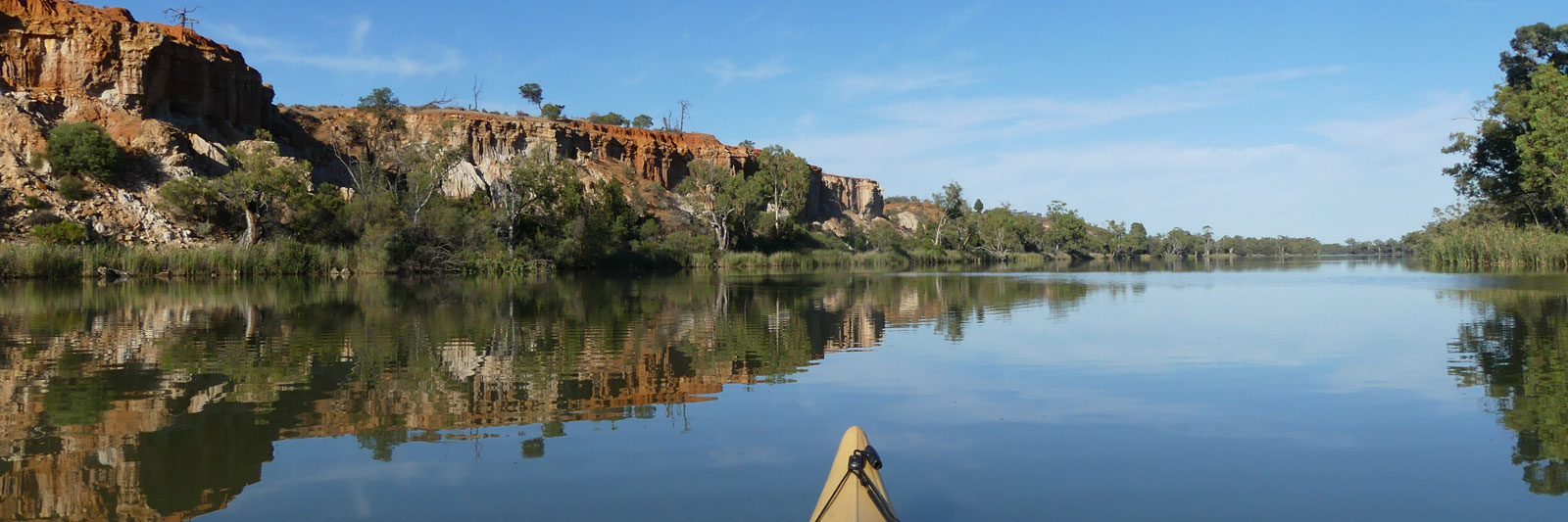
There were a number of really nice red clay banks along the river today, albeit most had multiple irrigation lines that cut down through them. I don't think I noticed a single untouched cliff today.
There were very few campers early on, but they were slowly building up as I paddled down the river and by the evening it was a struggle to find a camp away from people to ensure maximum social distancing with the covid thingie.

Campers were thinning out again, difficult to say if it was the weather or the covid restrictions. The mood is definitely starting to get more sombre on the people I talk to from the VIC side over the last day. I have a brief chat with the only person that I've seen for nearly a dozen nice camping spots and I discover why there isn't anyone about. The recent rain made many of the tracks impassable, even with 4WDs.
Downstream I come across a large family group canoe camping down from Robinvale to Nangiloc. Three or four generations from 2 to 80 in a half dozen Canadian Canoes. We talked for close to an hour before I headed off again.
Being Sunday and often poor reception I didn't do any chasing about the border closures.

I was still uncertain if I was going to get into SA or get stopped at Wentworth.
Even though it was a deferred public holiday, I tried my luck one last time with VIC and also SA for the first time. The SA hotline was simpler and I got into a queue that took maybe 15 to 20 minutes before I was talking to an operator. The lady I was talking too was definitely well versed in the actual health orders and she quickly went through the options. SA had an exception for people travelling on the Murray as long as they didn't disembark onto NSW soil. Also, if I had worn a mask at the Barham IGA, I would have been able to enter directly into SA today with a border pass as my trip would have fallen under the terms for travelling though NSW. Being maskless, that broke the conditions of this clause so that set the clock for the 14 day wait to be allowed in.
Finally got through to the VIC hotline. They finally added a queue so I had the chance to wait rather than rolling the dice by ringing back. After an hour on hold I managed to talk to the operator one full week after the announcement. Sadly they couldn't answer if the Murray was exempt. If they had read the health order this should have been clear and even if they hadn't they only needed to scan this briefly to see the exclusion. She put me on hold again to talk to her supervisor and even that person didn't know the rules and the "escalated" my case and told me they would call me back.
Having wasted half the day I camped a few hours paddling upstream of Mildura. There was definitely minimal current below Nangiloc.

My last supply point was in Mildura as I couldn't disembark onto the NSW shoreline at Wentworth without resetting my 14 day countdown to enter SA.
Based on the flow rate from above Nangiloc, I was expecting to have two rest days and a few easy paddling days waiting for the clock to tick over to enter SA. I decided to stock up on fresh food and wine to chill out while winding down the clock. While I noticed the flow reduction at Nangiloc, today with a heavily laden kayak I felt a bit like a beached whale.
Without a callback from the VIC officials, I turned to social media and got a response within minutes from a very helpful Victorian (not affiliated with any VIC government departments) with a link to the actual orders. There was an exception for the Murray in the orders as they were first released over a week ago. These were inline with those from SA.

The next day I waddled past Wentworth and had a missed call from VIC health on a private number telling me to call them back without leaving a number to call. Due to poor mobile reception I missed another call the following day, this time the message stated they would close the ticket if I didn't call. With my psychic powers not being strong enough and having passed the last VIC town, I just had to laugh and paddle on.
I only saw a couple of powerboats, half dozen fishermen and three houseboats between Mildura and Wentworth. What was meant to be one of the busiest sections was completely dead this year. Campers quickly thinned out below Wentworth. From a dozen caravans per beach to just one or two. It was still a very rare sight to see an empty beach.
Sick of my heavy load I find a below par campsite and take a rest day to consume as much of my load as possible!
Chilled down eating and drinking. A deferred New Years celebration. I made a good wack into the food and wine supply. It should make for some easier paddling tomorrow! As long as I don't have a hangover that is.

Fairly quiet day on the river today. I put my headphones and listen to some music as I paddle down. While the river gums still dominate the banks, you do start seeing more of the malle in places.

Usually shy birds, today I was lucky enough to have about six separate encounters throughout the day. Most were usually in pairs, but there was a small mob of six or more males at one spot. The highlight was a pair that came down to the water to drink within 10m of me. Without any hesitation, they continued into the river and quickly swum 100 m to the other side.
Today was the first time I actually got a nice VIC beach to camp on by myself.

After multiple emu sightings yesterday, I was seeing a large number of Kangaroos today. Dozens of Roos lined the banks at times. There are a number of nice cliffs along this section down to the border. A prelude to the showy cliffs in SA.
The borders are clearly marked with bright orange signs so these would be hard to miss. There was a slow small buildup in people as I neared the borders so I decided to make camp near the border rather than looking for something closer to the weir. I set up on the inside of the first bend as you enter SA, directly opposite a rather stunning cliff.

Well, technically I entered yesterday but I don't know if a remote bush camp counts.
After all of the mucking around organising the permits and getting information, all I got at the border was a single check at lock 6 where I was simply asked if I had a permit from the lock master. Apparently, SA did position a police officer there during the first lockdown, but with only about 5 boats per week they decided it wasn't worth an officer there for the second lockdown!
Below the lock marked the start of the houseboats again. These were most common around the towns as they only go 10 kph, sometimes less than that particularly if there was a headwind. I near Renmark late in the day and decide to stop early rather than pushing down to the lock that would be shut by the time I get there.

Up early and down to the lock 10 minutes early and I got let down by the lock master that hadn't even had his morning coffee yet.
It was quiet on the water below the lock and no other boats were seen all day. I get to Bookpurnong Weir / Lock 4 fairly early in the afternoon and become a temporary attraction for some sightseers visiting the weir.
I take a look at Katarapko Creek. There was a slight flow over the stone weir and I decided to take a detour down the small anabranch. There was just enough water to push the kayak down over the rocks. There were a few campers along the way and a lot of Kangaroos. I make camp at one of the many marked campsites along the river.

I still have the river mostly to myself, there were only two tinnies on the river above Moorook. Fairly overcast day with the odd shower, with the wind picking up all day. After multiple days with headwinds on the river already, this is an unwelcome return. The last ten clicks were extremely difficult and I'm glad to make it to a campsite for the night. On a positive note, it was a fantastic spot directly opposite one of the stunning sandstone cliffs.
This is about the start of the long straights and bends that seem to go on forever when you are paddling into a headwind.

The constant headwinds definitely became an issue in SA, the only question was how soon would they start and how hard would they blow. I don't know if I was unlucky with the weather or if the winds were being channeled up the Murray but even the locals were talking about how unusual these were on my trip down. Talking to one of the other paddlers who is also a sailer, he reckoned that these were up to 20 knots (37 kph), significantly faster than the observed 25 kph wind gusts by BoM.
The days blurred together heading down the final stretch. Get up, have nice window of enjoyable paddling from between 30 minutes and 2 hours, a moderate headwind by lunch and wickly nasty headwind by early afternoon. The strongest late afternoon winds seemed to always coincide with one of the small towns that had houses all along the river banks for miles downstream that forced you to keep paddling to find a spot for the night. I was thankful for my headphones that allowed me to keep pushing as well as helping me to keep my sanity. It would have been good to have had slightly less wind to allow me to enjoy this section of the river more.

While the cliffs are slowly fading away, the winds definitely aren't stopping. While there are sections of willow upstream, these get bad around Mannum and seem to choke out almost everything else along the banks as you head down to Lake Alexandrina.
The slow buildup of willows is causing a reduction in the number of possible campsites. Nearing Mannum, I decide to stop early and it takes forever to find something. Any cleared spot either seems to have houses, houseboats or No trespassing signs. I ended up with one of the worst campsites where I was literally camping in a swamp. I cleared just enough of some long elephant grass for my bivy and I was forced to cook on a tree stump that was sticking out of the water. I had to laugh at myself after paddling past Mannum in the morning where I noticed a lot of possible campsites.
Dairy farming becomes much more common towards the mouth with long narrow paddocks filled with cows. I ended up camping next to a large herd of cows on one of the levies.

I wake early before dawn just moments before the pump shed beside me starts up for the morning milking. I cruise down past Tailem Bend and Wellington before the wind started, but it was fairly strong as I reached Lake Alexandrina.
Any hope of a direct crossing today was gone but I hadn't given up on a shoreline traverse yet, so I paddled down the left hand side, trying to tuck in behind the willows for some respite from the strengthening headwinds. I was greeted with a howling southerly wind when I arrived at what I thought was Low Point. Without a spray deck I was starting to collect an increasing amount of water in the kayak and I took that as a sign it was time to stop. So around midday I set up camp on a beach just before Low Point.

Up well before dawn, I packed up my sleeping gear and headed out onto the lake.
The lake was as smooth as glass close to the shore with only a minor ripple once I
was fully out onto the lake. I must have done close to an hour's worth of paddling before the
sun finally peaked up from beyond the horizon. A slight cross wind from the east
started that was a bit peculiar after the constant southerlies. This seemed
to swing to the NE as I tracked SW towards the Narrows, and from the north as I
headed south to the barrages giving me a constant tailwind all day and even a
following sea lake at times.
The track taken was roughly Low Point to Poltalloch Station (7 km) before following the shoreline around to Loveday Bay where I cut across to the eastern end of Towatchery Barrage (two crossing at about 2.0 km and 1.6 km). As an aside, the lock was on the western side. It was a choppy paddle across to the lock as waves bounced off the barrage gate.
The left hand Tauwitchere Barrage didn't have a contact number to call and I had to portage over the barrage wall. at the time I didn't know the lock was self-operated, but that wouldn't have helped being by myself!

After stopping at the mouth, I sat and watched the ocean for a while. Any thoughts of potentially paddling back to Victoria quickly left as I watched the strong southerly winds churn up the ocean. I headed back to Goolwa but I was too late getting to the lock and I was forced to do a long 2 km portage. Paddled past before continuing around Goolwa to the camping ground on Hindmarsh Island to camp for the night.
I caught a bus to the train that got me into Adelaide. The next day I had a red-eye morning bus to Bendigo and another onto Wangaratta, and had some luck getting a ride directly to Corryong the following day instead of yet another train and bus trip.
Just after getting my car in Corryong, I noticed a very faint cold like symptoms that got slightly worse as I started driving back for the kayak. With a COVID test in Wodonga I got the self isolation message with the OK to continue with stops for drive through and petrol only. So I had a rather boring 33 hour drive to pick up my kayak and return home to Queensland with just two stops for some fast food and a couple more for petrol. The restrictions at the time stated that anyone with recent cold like symptoms must first pass a test before entering Queensland. Thankfully the results came through just hours before the border allowing me to cross in.
It felt like a rather ironic way to finish the trip after having to deal with all of the border restrictions along the river!

©2024 Alan Davison // Credit // Disclaimer